


Click here for Saturday's Updates: KNP Complex Wildfires in Sequoia National Park Saturday, October 2, 2021 Updates
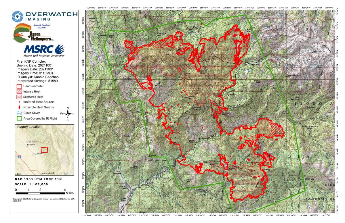
Friday's Infrared Map
Note: Map is 1,200 pixels wide.
Click here for Saturday's Updates: KNP Complex Wildfires in Sequoia National Park Saturday, October 2, 2021 Updates
Update 12:10 P.M.
Sheriff Boudreaux has issued EVACUATION ORDERS for the communities of Big Meadows, Weston Meadows, and Quail Flat in the Giant Sequoia National Monument. Please use Highway 180 westbound to evacuate the area.
The temporary evacuation point, where you may find information and assistance is at the Woodlake Community Center at 145 N. Magnolia. If you need assistance with evacuation, please call 9-1-1.
An evacuation order means an immediate threat to life, safety, and property and all residents and visitors must leave now before the fire reaches the community.
Update 10:00 A.M.
EVACUATION ORDER: Sequoia and Kings Canyon National Parks Issue Mandatory Evacuation for Grant Grove, Wilsonia and Cedar Grove Communities
National Park Service residents should meet at the Bear Mountain Library at 1500. The library is at 30733 East Kings Canyon Road Squaw Valley, CA 93675. Specific information regarding lodging arrangements for displaced residents will be available at the library. Speak with your supervisor for work assignments. Call park Dispatch at 559-565-3195 for urgent concerns or questions.
Sequoia & Kings Canyon NPS YouTube Channel
(View the recordings of the latest community meetings and daily operational updates here)
Southwest Area Type 1 Incident Management Team 2
Dave Bales – Incident Commander
Acres: 51,596 acres (based on infrared flight)
Containment: 20%
Start Date: September 10, 2021
Cause: Lightning
Jurisdiction: Sequoia and Kings Canyon National Park
Resources: 1,494 personnel including: 26 crews, 61 engines, 40 water tenders, 21 dozers and 12 helicopters
Yesterday, firefighters on the northwest corner saw an increase in fire behavior as weather conditions became hotter and drier throughout the day. The fire continued to back down towards North Fork Kaweah River until mid-afternoon when the fire spotted across the river. This prompted Evacuation Orders for the communities of Eshom and Hartland Camp. Evacuation Warnings were also issued for the community of Badger in Tulare County and the Miramonte and Pinehurst areas in Fresno County. Air tankers and helicopters worked the spot fire into the evening hours with retardant and water drops in an effort to slow the spread. Fire managers shifted available resources to the threatened communities to reinforce structure protection efforts. More resources continue to be ordered to support the incident.
Firefighters on the eastern flank were able to extend containment lines north from the Lodgepole campground area. Crews continued securing containment lines by extinguishing hotspots along the fireline and within the Giant Forest Grove. Unmanned Aircraft Systems (UAS) were utilized to gather information along the eastern perimeter near Middle Fork and south towards Mineral King Rd. Along the southern perimeter, additional fire crews continued improving the Mineral King Rd. as a holding feature, while also scouting for opportunities to engage the fire perimeter directly.
Today, resources will continue with structure protection in Eshom and Hartland as they work to gain direct access to the spot fire. Should the fire continue to spread north, firefighters may conduct tactical firing operations along the Generals Highway and within the Redwood Mountain Grove if conditions are favorable. Crews working on the northern flank of the fire, east of the Generals Highway, will be improving established containment lines while they progress east. On the southwestern flank, firefighters will continue to extinguish isolated sources of heat and maintain a presence in the communities of Three Rivers and Ash Mountain. Today, weather conditions will be similar to yesterday and an increase in fire activity can be expected. Aircraft will continue to support firefighters on the ground as visibility permits.
Evacuation Orders were reduced to a Warning for some residences in the Mineral King and Three Rivers areas yesterday afternoon and increased for Eshom and Hartland Camp. Evacuation Warnings were issued for Badger and the Miramonte and Pinehurst areas. Detailed evacuation information for Tulare County can be found at: https://tularecounty.ca.gov/emergencies/ and for Fresno County at: https://www.facebook.com/FresnoSheriff.
Basic Information
| Current as of | 10/1/2021, 7:02:32 AM |
| Incident Type | Wildfire |
| Cause | Lightning |
| Date of Origin | Friday September 10th, 2021 approx. 07:00 AM |
| Location | Sequoia National Park |
| Incident Commander | David Bales |
| Incident Description | Complex |
| Coordinates | 36.567 latitude, -118.811 longitude |
Current Situation
| Total Personnel | 1,494 |
| Size | 51,596 Acres |
| Percent of Perimeter Contained | 20% |
| Fuels Involved |
Timber (Litter and Understory) Chaparral (6 feet) Short Grass (1 foot) |
| Significant Events |
Observed Fire Behavior: Extreme Uphill Runs Running Group Torching Fire behavior increased with the decrease in humidity. Very active fire behavior around much of the fire. |
Outlook
| Planned Actions |
Utilize direct and indirect tactics including both hand crews and heavy equipment to continue line construction along Cal Fire protection areas and outside the western park boundary to provide for structure protection and minimize impacts to values at risk in Three Rivers, Silver City, Hartland, Eshom and surrounding communities. Planned initiation of backfiring operations along Redwood Mountain Grove to minimize fire severity within the giant sequoia stand. Utilize direct tactics where feasible and with a high prob-ability of success to limit further fire spread. Improve structure protection and mitigation efforts for National Park infrastructure. Continue to monitor high-value infra-structure within the National Park to include the Park Headquarters, Museum, and employee housing. Continued protection and mitigation measures for all sequoia groves within the fire area, including the Giant Forest Sequoia Grove. When attributes of fire behavior are favorable to the landscape, allow fire spread to aid in fuels reduction in and adjacent to the groves. Utilize strategic firing when needed to help meet the objectives identified for this fire. |
| Projected Incident Activity |
12 hours: Fire behavior will continue to be active into the night with the lower humidity. 24 hours: Very active to extreme fire behavior with the lower humidity. Expect movement to the south backing to the Mineral King road and north across the North Fork. 48 hours: With the increase in temperature and lower humidity expect to see very active to extreme fire behavior. Continue to see growth north and south. 72 hours: Low humidity will provide for the fire behavior to stay at very active to extreme. Smoke will help moderate some areas of the fire. Anticipated after 72 hours: Smoke and slightly higher humidity will help moderate the fire behavior. Expect to see active to very active fire behavior. |
Current Weather
| Weather Concerns |
High pressure continues to keep winds light around the fire line. Dense smoke in the morning began to mix in the early afternoon, leading to clearer visibility. Widespread RH below 25% in the afternoon. High pressure will keep these conditions persistent through the weekend. |
October 1, 2021 - KNP Complex Fire in Sequoia National Park updates for Friday: 51,589 Acres.
Overnight Infrared Flight Notes: Interpreted Size: 51,589 Interpreted Acres - Growth since last flight: 2,240 Acres
Observed perimeter growth on the SE and Northern side of the perimeter.
System Techs: Clear sky from the ground up to our altitude. LWIR was fine.
Click here for: KNP Complex Wildfires in Sequoia National Park Thursday, September 30, 2021 Updates
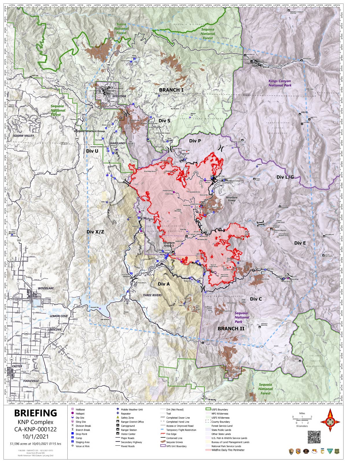
Friday's Briefing Map
Briefing Map Shows Divisions, Uncontrolled Fire Edge, Completed Dozer Lines.
Note: Map is 1,200 pixels wide.
Yesterday: Tulare County Sheriff's Office
Sheriff Issues NEW Evacuation Orders, Warnings for the KNP Complex Fire
Sheriff Boudreaux has issued EVACUATION ORDERS for the communities of Eshom and Hartland Camp, including Eshom Valley Drive, from Fresno County Line, South to Tarbell Pocket on Eshom Valley Drive, and North Mountain Road, 468 North to the County line. The evacuation order includes all structures, side roads, associated roads, and forest service roads, due to the KNP Complex Fire.
To evacuate, please use Eshom Valley to Stage Coach, to Highway 245 or Dry Creek.
An evacuation order means an immediate threat to life, safety, and property and all residents and visitors must leave now before the fire reaches the community. If you need assistance with evacuation, please call 9-1-1.
A road closure is in effect at Eshom Valley Road and Stage Coach.
An EVACUATION WARNING has been issued for the community of Badger to the North Tulare County Boundary, including Whittaker Forest Road, Hogback Road, CA 245, Dry Creek, Sierra Glenn, all the way to Wild Hog Canyon. Then South to Deep trail, Shadley Jeep Trail. Then East to Eshom Valley Road and North to the Tulare County Boundary. Including all structures, side roads, associated roads, and forest service roads.
Evacuation warnings are voluntary. Community members are strongly encouraged to prepare to evacuate if it becomes necessary. If individuals feel they need more time, please consider leaving the area now.
The temporary evacuation point, where you may find information and assistance is at the Woodlake Community Center at 145 N. Magnolia. Individuals with RVs/Trailers may find information about where they can park at the College, or you may go to the International Agri-Center 4500 W. Laspina in Tulare, Gate D, where you may dry camp.
When preparing to evacuate, please consider bringing important documents, necessary medication, changes of clothing, and hygiene items. If you are able to evacuate your domestic animals, remember to pack food, leashes, and other items. If you are not able to plan to evacuate your domestic animals or livestock, please make arrangements with Tulare County Animal Services prior to transporting your animals to an available shelter location by completing the Fire Assistance Evacuation Form located on the Tulare County Animal Services website at: https://tcanimalservices.org/.../animal-evacuation-form/....
All evacuation orders and warnings remain in effect for the KNP Complex Fire.
Please refer to https://tularecounty.ca.gov/emergencies/ for the Windy Fire Evacuation Warning Area Map. Call 2-1-1 for more information. Log on to https://inciweb.nwcg.gov/incident/7841/ for incident information.
