Click here for Sunday's Updates: KNP Complex Wildfires in Sequoia National Park Sunday, October 3, 2021 Updates
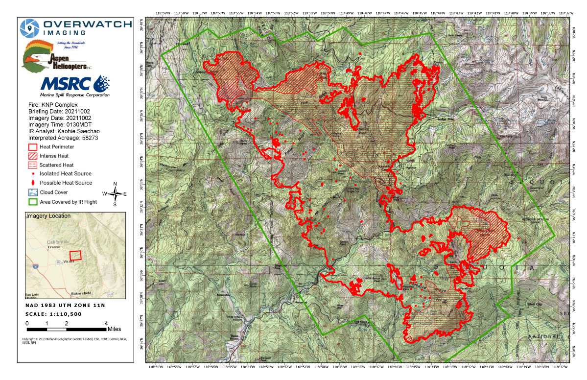
Saturday's Infrared Map
Note: Map is 1,200 pixels wide.
Click here for Sunday's Updates: KNP Complex Wildfires in Sequoia National Park Sunday, October 3, 2021 Updates
Update: 11:25 A.M.
EVACUATION WARNING: Sequoia Lake, Cedarbrook, Etheda Springs and Pinehurst per Fresno County Sheriff. The specific zones are K88 and K89. An evacuation warning means potential threat to life/property. Folks who need extra time and those with animals should leave now
Update: Southwest Area Type 1 Incident Management Team 2
Dave Bales – Incident Commander
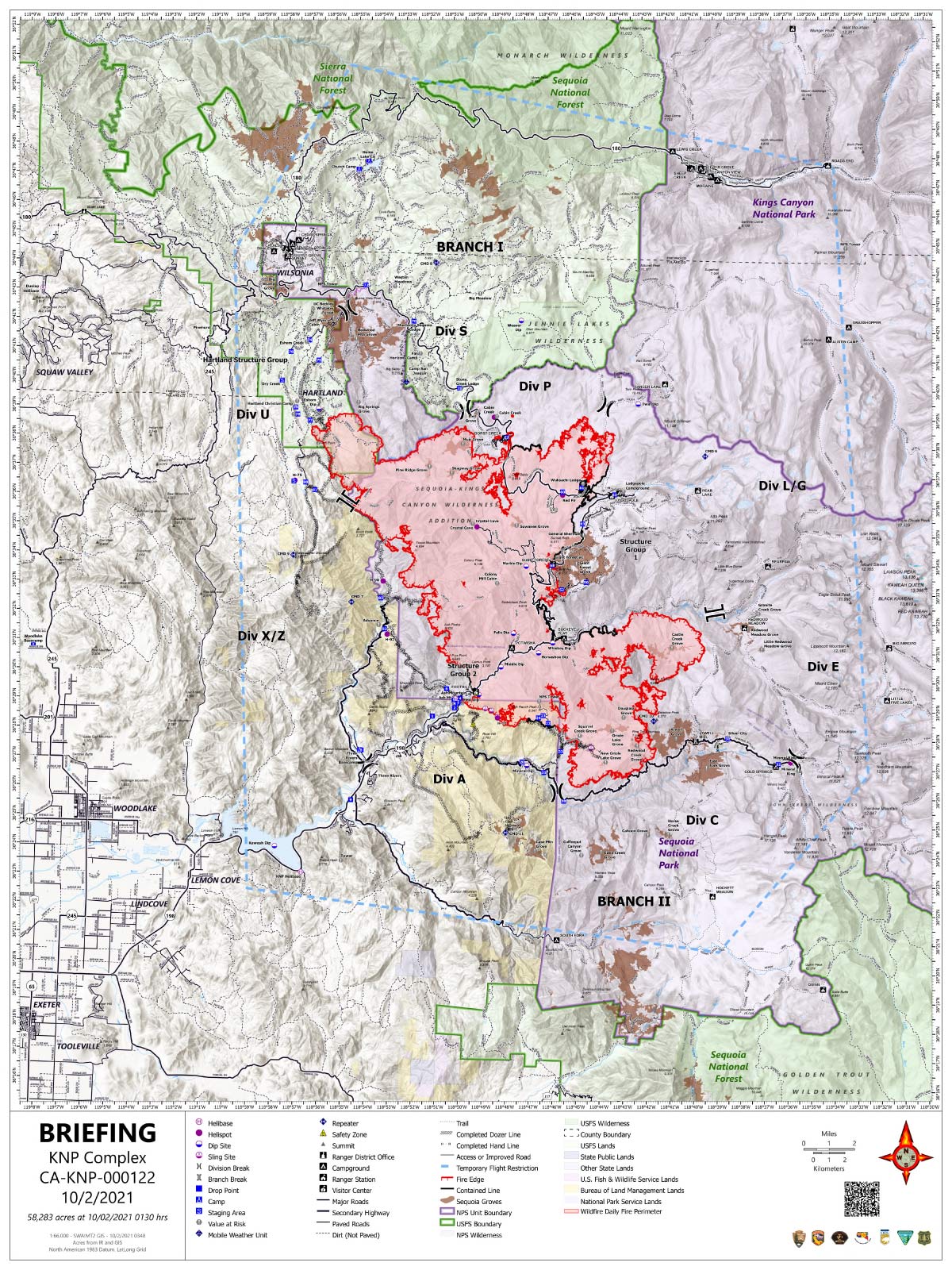
Acres: 58,283 acres (based on infrared flight)
Containment: 20%
Start Date: September 10, 2021
Cause: Lightning
Jurisdiction: Sequoia and Kings Canyon National Parks
Resources: 1,345 personnel including: 26 crews, 61 engines, 40 water tenders, 21 dozers and 12 helicopters
Virtual Meeting Today at 7:00 PM streamed on Facebook Live https://www.facebook.com/SequoiaKingsNPS/live_videos
Yesterday, the northwest flank where the fire crossed the North Fork Kaweah River and the eastern perimeter near Castle Creek Grove experienced the most active fire behavior and new growth. Resources on the northern perimeter initiated successful tactical firing operations in the Redwood Mountain Grove, along the Generals Highway towards Dorst Campground and south of Eshom Point along northwest contingency lines as conditions were favorable. Throughout the night firefighters continued strategic firing operations to secure contingency lines. The fire has burned onto both Kings Canyon National Park and Sequoia National Forest.
Today, low-intensity tactical firing operations will progress within the Redwood Mountain Grove, along the Generals Highway and along northwest contingency lines south of Eshom Point if conditions are favorable. Resources will continue structure protection efforts in the communities of Eshom and Hartland by removing debris away from structures, setting up sprinklers and installing hose lays. Crews east of the Generals Highway along the northern perimeter will work to improve established containment lines working to the east. Firefighters on the eastern flank will continue securing the Giant Forest Grove while also supporting strategic firing operations to the north as needed. As additional resources arrive to the southern perimeter, they will continue with indirect suppression tactics along Mineral King Rd and scout for opportunities to safely engage the fire perimeter directly. The fire is expected to progress further south, down slope towards the road today. Firefighters remain in the communities of Three Rivers and Ash Mountain as an increase in fire behavior was observed yesterday. Along the western perimeter, an Unmanned Aircraft System (UAS) will be utilized to gather information which will be used to inform operational plans. Aircraft will support ground resources as air quality permits.
Humidity recovery was poor overnight and relative humidity levels are expected to remain low today. A ridge of high pressure remains over the fire bringing hot and dry conditions. Winds will be primarily terrain driven and are not expected to surface over the fire until mid-afternoon. Active fire behavior is expected again today.
Evacuation warnings and orders are still active. Areas currently under an evacuation warning are urged to be ready to mobilize and leave should the warning escalate to an evacuation order. Detailed evacuation information for Tulare County can be found at: https://tularecounty.ca.gov/emergencies/ and for Fresno County at: https://www.facebook.com/FresnoSheriff.
Sequoia and Kings Canyon National Parks are closed west of the Pacific Crest Trail and south of the ridgeline which lies north of Ionian Basin. In addition, the BLM Case Mountain Extensive Recreation Management Area and major portions of the Sequoia National Forest are also closed.
Communities surrounding the park and in the nearby region are being affected by smoke and the resulting poor air quality. Track your local air quality at https://www.wildlandfiresmoke.net/outlooks/FresnoCA.
Update 7:50 A.M. 58,283 Acres with 20% Containment
Basic Information
| Current as of | 10/2/2021, 6:58:55 AM |
| Incident Type | Wildfire |
| Cause | Lightning |
| Date of Origin | Friday September 10th, 2021 approx. 07:00 AM |
| Location | Sequoia National Park |
| Incident Commander | David Bales |
| Incident Description | Complex |
| Coordinates | 36.567 latitude, -118.811 longitude |
Current Situation
| Total Personnel | 1,345 |
| Size | 58,283 Acres |
| Percent of Perimeter Contained | 20% |
| Fuels Involved |
Timber (Litter and Understory) Chaparral (6 feet) Short Grass (1 foot) |
| Significant Events |
Observed Fire Behavior: Extreme Uphill Runs Running Group Torching Fire behavior continues to increase with poor overnight recovery and low humidity. Very active to extreme fire behavior on the northwest end and the southeast portion of the fire, south of the Middle Fork. |
Outlook
| Planned Actions |
Utilize direct and indirect tactics including both hand crews and heavy equipment to continue line construction along Cal Fire protection areas and outside the western park boundary to provide for structure protection and minimize impacts to values at risk in Three Rivers, Silver City, Hartland, Eshom and surrounding communities. Planned initiation of backfiring operations along Redwood Mountain Grove to minimize fire severity within the giant sequoia stand. Utilize direct tactics where feasible and with a high prob-ability of success to limit further fire spread. Improve structure protection and mitigation efforts for National Park infrastructure. Continue to monitor high-value infra-structure within the National Park to include the Park Headquarters, Museum, and employee housing. Continued protection and mit-igation measures for all sequoia groves within the fire area, including the Giant Forest Sequoia Grove. When attributes of fire behavior are favorable to the landscape, allow fire spread to aid in fuels reduction in and adjacent to the groves. Utilize strategic firing when needed to help meet the obj-ectives identified for this fire. |
| Projected Incident Activity |
12 hours: Fire behavior will continue to be active to very active into the night with the lower humidity. 24 hours: Very active to extreme fire behavior with the lower humidity. Fire will continue to move north into the Redwood drainage and into the Pierce Creek drainage. Eastward movement on the east side south of the Middle Fork and continued backing towards the Mineral King road. 48 hours: Not much change in the fire weather so expect the continuation of the active to very active fire behavior with some extreme fire behavior in isolated areas. 72 hours: Temperatures increase along with the low humidity expect to see more very active fire behavior and north and south movement. Anticipated after 72 hours: Humidity begins to climb allowing for less fire behavior, however it is still low enough to fuel active fire behavior. |
Current Weather
| Weather Concerns |
Smoke remained persistent across the fire Friday. Winds aloft became light and variable, keeping smoke from mixing out around the fire. Humidity fell below 15 percent. Inversion will hold smoke in place overnight, with more persistent smoke on Saturday. |
October 2, 2021 - KNP Complex Fire in Sequoia National Park updates for Saturday: 58,273 Acres.
Overnight Infrared Flight Notes: Interpreted Size: 58,273 Interpreted Acres - Growth since last flight: 6,684 Acres
Observed perimeter growth on the SE and NW side of the perimeter.
System Techs: Can smell smoke as we approach the fire at 14,500ft. smoke over the fire. Can see glow visually. Good LWIR look. Definitely smokier and hazier than previous nights
Click here for: KNP Complex Wildfires in Sequoia National Park Friday, October 1, 2021 Updates
Saturday's Briefing Map
Briefing Map Shows Divisions, Uncontrolled Fire Edge, Completed Dozer Lines.
Note: Map is 1,200 pixels wide.