Click here for Monday's Updates: KNP Complex Wildfires in Sequoia National Park Monday, October 4, 2021 Updates
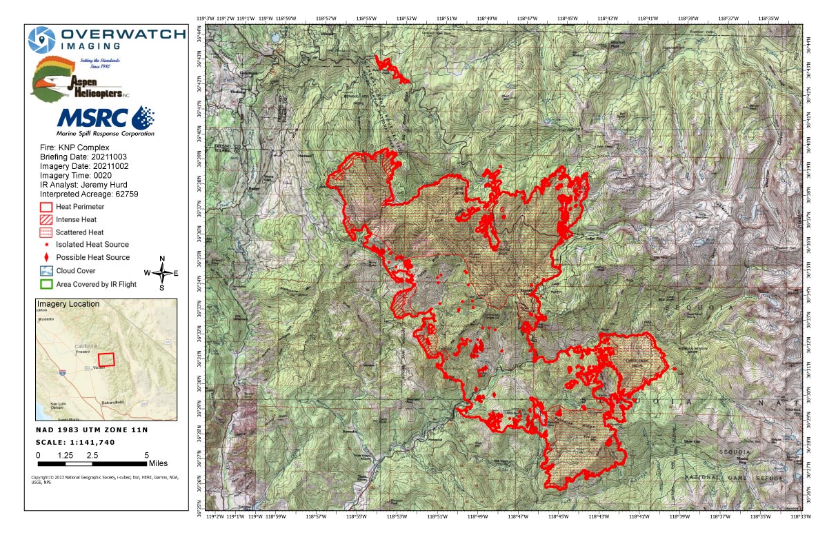
Sunday's Infrared Map
KNP Complex Wildfires in Sequoia National Park Monday, October 4, 2021 Updates
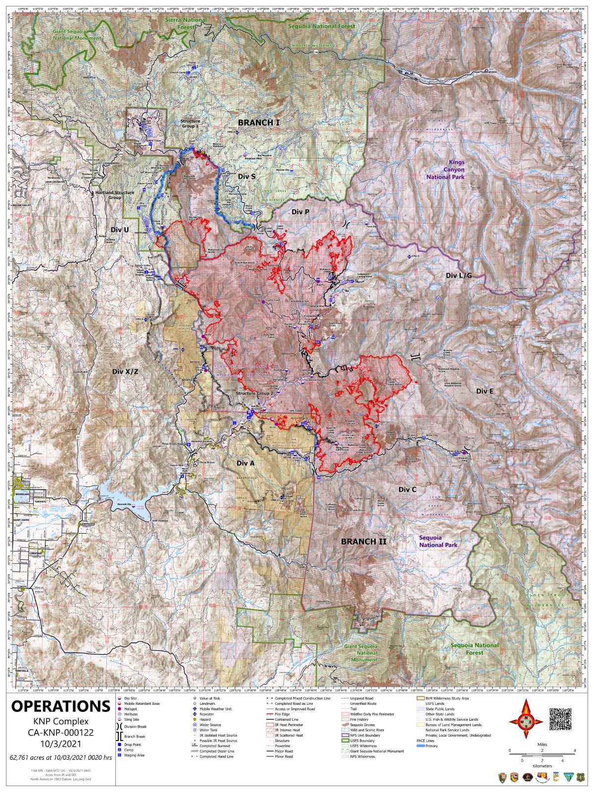
Note: Map is 1,200 pixels wide.
Click here for Monday's Updates: KNP Complex Wildfires in Sequoia National Park Monday, October 4, 2021 Updates
Update 11:00 A.M.
Southwest Area Type 1 Incident Management Team 2
Dave Bales – Incident Commander
Acres: 62,761 acres (based on infrared flight) Containment: 20%
Start Date: September 10, 2021 Cause: Lightning
Jurisdiction: Sequoia and Kings Canyon National Parks, and Sequoia National Forest
Resources: 1,357 personnel including: 26 crews, 61 engines, 40 water tenders, 21 dozers and 12 helicopters
Firefighters had another successful day because the smoke inversion kept fire activity from becoming extreme. Tactical firing operations continued along the northwest perimeter. Structure protection efforts are on-going for the communities of Eshom and Hartland. Crews on the northern flank progressed through Redwood Mountain Grove conducting firing operations to secure lines and minimize potential future fire impacts. Resources along Generals Highway progressed north to Cabin Creek with successful tactical firing operations as well.
Today, firefighters anticipate similar conditions depending on how weather and smoke lift out later in the day. Structure protection and tactical firing operations continue on the northwest corner of the fire. As conditions permit, crews will progress with tactical firing operations within the Redwood Mountain Grove and north of Cabin Creek along Generals Highway. Firefighters on the eastern flank continue securing the Giant Forest Grove while also supporting strategic firing operations to the north. On the southern perimeter, firefighters continue indirect suppression tactics improving Mineral King Rd. Resources are being shifted to the community of Silver City and the Mineral King area for structure protection as the fire continues to move south and east. Firefighters on the southwest edge remain in the communities of Three Rivers and Ash Mountain. Additional federal, state, and local resources are arriving, supporting firefighting efforts and being placed where needed. Aviation assets are available to support ground personnel as smoke and visibility permits.
Active fire behavior is expected as a ridge of high pressure remains over the fire bringing continued hot, dry, and smoky conditions. Humidity levels are expected to remain low while winds will continue to be light and terrain driven.
Evacuation orders and warnings remain in effect. Detailed KNP Complex evacuation information can be found at https://tularecounty.ca.gov/emergencies/ and https://www.facebook.com/FresnoSheriff.. Information about how to prepare for evacuations can be found at https://www.readyforwildfire.org/.
Sequoia and Kings Canyon National Parks are closed west of the Pacific Crest Trail and south of the ridgeline which lies north of Ionian Basin. In addition, the BLM Case Mountain Extensive Recreation Management Area and major portions of the Sequoia National Forest are also closed.
Communities surrounding the park and in the nearby region are being affected by smoke and poor air quality. Track your local air quality at https://www.wildlandfiresmoke.net/outlooks/FresnoCA.
Update 9:00 A.M. Smoke/Air Quality Outlook for the KNP Complex Wildfires in Sequoia National Park for Sunday, October 3, 2021
Update 8:45 A.M. 67,761 acres with 20% containment
Basic Information
| Current as of | 10/3/2021, 8:34:09 AM |
| Incident Type | Wildfire |
| Cause | Lightning |
| Date of Origin | Friday September 10th, 2021 approx. 07:00 AM |
| Location | Sequoia National Park |
| Incident Commander | David Bales |
| Incident Description | Complex |
| Coordinates | 36.567 latitude, -118.811 longitude |
Current Situation
| Total Personnel | 1,357 |
| Size | 67,761 Acres |
| Percent of Perimeter Contained | 20% |
| Fuels Involved |
Timber (Litter and Understory) Chaparral (6 feet) Short Grass (1 foot) |
| Significant Events |
Observed Fire Behavior: Extreme Uphill Runs Running Short-range Spotting Narrative: Poor overnight recovery allowed for an early start to the burn day. Very active to extreme fire behavior was observed around the fire. Movement to the north, east and south. |
Outlook
| Planned Actions |
Utilize direct and indirect tactics including both hand crews and heavy equipment to continue line construction along Cal Fire protection areas and outside the western park boundary to provide for structure protection and minimize impacts to values at risk in Three Rivers, Silver City, Hartland, Eshom and surrounding communities. Continue firing operations in the areas of Eshom Point, Dorst Campground, along General's Highway, and along Redwood Mountain Grove to minimize fire severity within the giant sequoia stand. Utilize direct tactics where feasible and with a high probability of success to limit further fire spread. Improve structure protection and mitigation efforts for National Park infrastructure. Continue to monitor high-value infrastructure within the National Park to include the Park Headquarters, Museum, and employee housing. Continued protection and mitigation measures for all sequoia groves within the fire area, including the Giant Forest Sequoia Grove. When attributes of fire behavior are favorable to the landscape, allow fire spread to aid in fuels reduction in and adjacent to the groves. Utilize strategic firing when needed to help meet the objectives identified for this fire. |
| Projected Incident Activity |
12 hours: Fire behavior will continue to be active to very active into the night with the lower humidity. 24 hours: Very active to extreme fire behavior with the lower humidity and poor overnight recovery. Fire will continue to move north up the Redwood drainage and into the Pierce Creek drainage. Eastward movement on the east side south of the Middle Fork and continued backing towards the Mineral King road. 48 hours: Another dry day with poor recovery. Active to very active fire behavior with some extreme fire behavior in isolated areas. 72 hours: Humidity levels begin to climb allowing the fine dead fuels to moisten. Fire behavior will moderate with the moist fuels. Expect to see active to very active fire behavior. Anticipated after 72 hours: Higher humidity will continue to moisten fuels and lowering the fire behavior. |
Current Weather
| Weather Concerns |
High pressure continues to hold smoke in place across the fire. Winds remain light and terrain-driven, while winds aloft have minimal push on the smoke. Humidity levels remain very low, below 15% during the day and below 25% at night. These conditions will continue Sunday and Monday. |
October 3, 2021 - KNP Complex Fire in Sequoia National Park updates for Sunday: 62,759 Acres.
Overnight Infrared Flight Notes: Interpreted Size: 62,759 Interpreted Acres - Growth since last flight: About 4,486 Acres
No flight notes for today.
Click here for: KNP Complex Wildfires in Sequoia National Park Saturday, October 2, 2021 Updates
Sunday's Operations Map
Operations Map Shows Divisions, Uncontrolled Fire Edge, Completed Dozer Lines.
Note: Map is 1,200 pixels wide.