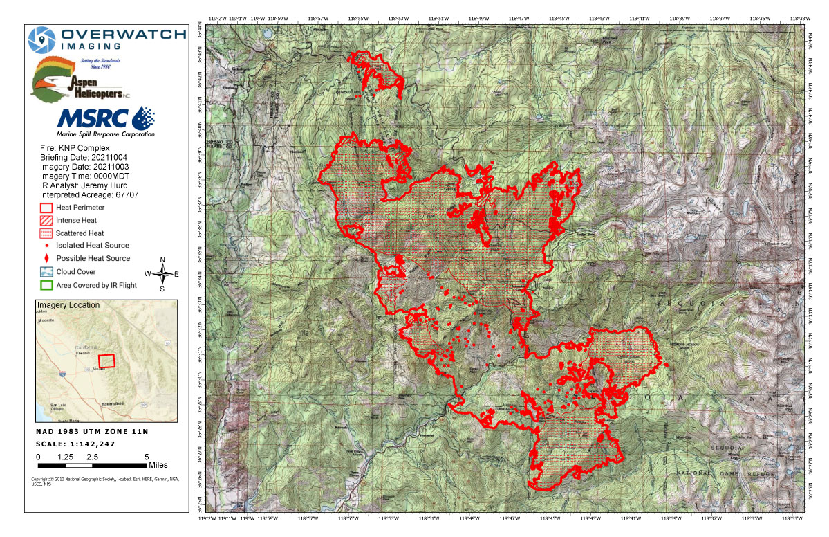
Monday's Infrared Map
Note: Map is 1,200 pixels wide.
Update: Smoke/Air Quality Outlook for the KNP Complex Wildfires in Sequoia National Park for Monday, October 4, 2021
Update 6:30 A.M.
HAPPENING NOW: New Evacuation Orders Underway For KNP Complex Fire Tulare County Sheriff's Facebook Page
Sheriff Boudreaux has issued an evacuation order for the following residences in the Mineral King area, Gateway, to the Park Entrance including Sycamore Dr.
The area will include Mineral King Rd from Highway 198 to the Oak Grove Bridge, including Crest, Sierra King, Hammond, and Oak Grove. There will be a road closure at Highway 198 at Mineral King Rd.
The Evacuation Order will include: Mineral King Dr up to the Sequoia National Park Boundary, including associated structures along both sides of HWY 198 to the Park Boundary. Including, Oak Grove Bridge down to HWY 198, including Sierra King Dr, Crest Lane, Hammond Dr, Oak Grove Dr. Not including Dinely Dr.
Evacuation WARNINGS still remain in place for all structures from Old Three Rivers Rd and Blossom Dr to South Fork Dr, including South Fork Dr up HWY 198 to Mineral King Dr, including North Fork Dr, also including all side roads along HWY 198 to Mineral King Dr.
Please refer to https://tularecounty.ca.gov/emergencies/ KNP Complex Evacuation Area Map for more information.
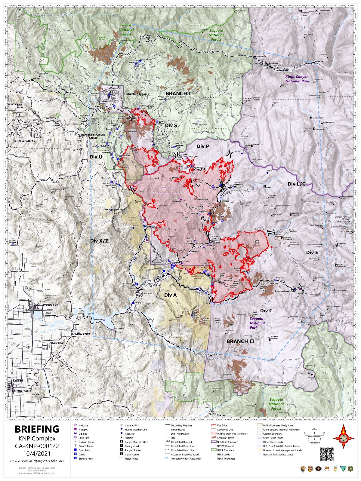
Basic Information 67,708 Acres with 20% Containment
| Current as of | 10/4/2021, 7:11:21 AM |
| Incident Type | Wildfire |
| Cause | Lightning |
| Date of Origin | Friday September 10th, 2021 approx. 07:00 AM |
| Location | Sequoia National Park |
| Incident Commander | David Bales |
| Incident Description | Complex |
| Coordinates | 36.567 latitude, -118.811 longitude |
Current Situation
| Total Personnel | 1,531 |
| Size | 67,708 Acres |
| Percent of Perimeter Contained | 20% |
| Fuels Involved |
Timber (Litter and Understory) Chaparral (6 feet) Short Grass (1 foot) |
| Significant Events |
Observed Fire Behavior: Extreme Uphill Runs Running Short-range Spotting Low humidity will continued to drive the moisture out of the fuels allowing for very active to extreme fire behavior. |
Outlook
| Planned Actions |
Utilize direct and indirect tactics including both hand crews and heavy equipment to continue line construction along Cal Fire protection areas and outside the western park boundary to provide for structure protection and minimize impacts to values at risk in Three Rivers, Silver City, Hartland, Eshom and surrounding communities. Continue firing operations in the areas of Eshom Point, Dorst Campground, along General's Highway, and along Redwood Mountain Grove to minimize fire severity within the giant sequoia stand. Utilize direct tactics where feasible and with a high probability of success to limit further fire spread. Improve structure protection and mitigation efforts for National Park infrastructure. Continue to monitor high-value infrastructure within the National Park to include the Park Headquarters, Museum, and employee housing. Continued protection and mitigation measures for all sequoia groves within the fire area, including the Giant Forest Sequoia Grove. When attributes of fire behavior are favorable to the landscape, allow fire spread to aid in fuels reduction in and adjacent to the groves. Utilize strategic firing when needed to help meet the objectives identified for this fire. |
| Projected Incident Activity |
12 hours: Fire behavior will continue to be active to very active into the night with the lower humidity. 24 hours: Active to extreme fire behavior with the humidity and poor overnight recovery. The addition of the solar radiation will help keep the fire behavior elevated. Fire will continue to move north up the Redwood drainage and into the Pierce Creek drainage. Eastward movement on the east side south of the Middle Fork and continued backing towards the Mineral King road. 48 hours: As the humidity increases the fire behavior will begin to decrease. Expect to see moderate to very active fire behavior. 72 hours: Moderate fire behavior can be expected with minimal growth. Anticipated after 72 hours: Higher humidity will continue to moisten fuels and lowering the fire behavior. |
Current Weather
| Weather Concerns |
High pressure continues to hold smoke in place due to light winds. Humidity remains very low, and will recover very little overnight. The ridge will break down during the next couple days, bringing increased humidity and allowing some smoke mixing each afternoon. |
October 4, 2021 - KNP Complex Fire in Sequoia National Park updates for Monday: 67,707Acres.
Overnight Infrared Flight Notes: Interpreted Size: 67,707 Interpreted Acres - Growth since last flight: About 4,948 Acres
No flight notes for today.
Click here for: KNP Complex Wildfires in Sequoia National Park Sunday, October 3, 2021 Updates
Monday's Briefing Map
Briefing Map Shows Divisions, Uncontrolled Fire Edge, Completed Dozer Lines.
Note: Map is 1,200 pixels wide.