Click here for Tuesday's Update: KNP Complex Wildfires in Sequoia National Park Tuesday, October 12, 2021 Updates
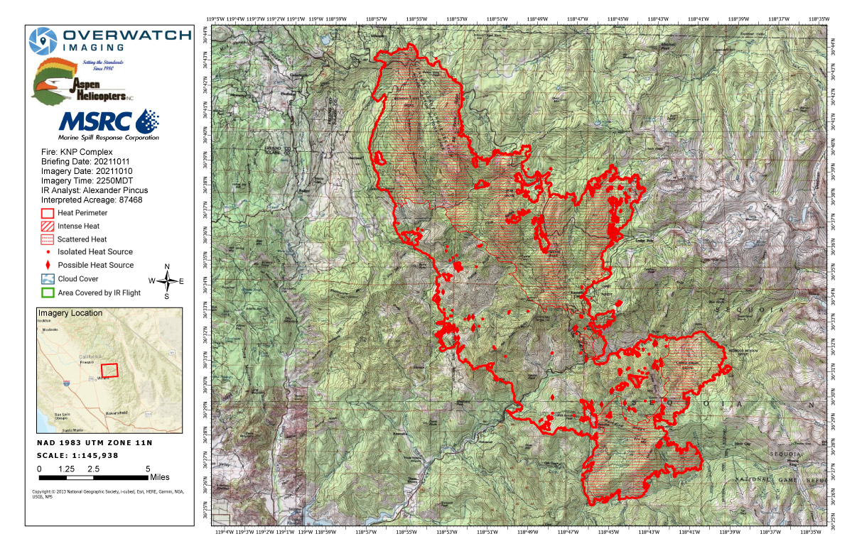
Monday's Infrared Map
Note: Map is 1,200 pixels wide.
Click here for Tuesday's Update: KNP Complex Wildfires in Sequoia National Park Tuesday, October 12, 2021 Updates
Update 1:25 P.M.
We are aware that an accident involving rolling material occurred at approximately 11:15 am in the vicinity of Atwell Grove area. Agency personnel are responding. Additional information will be released as it becomes available.
Update 10:00 A.M.
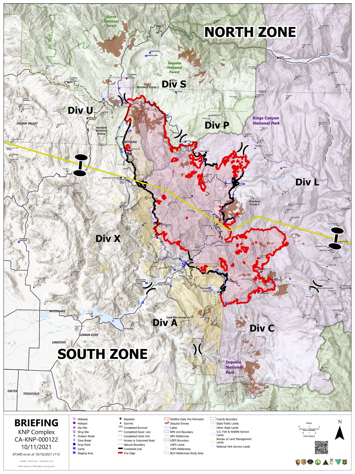
Acres: 87,468 acres
Containment: 30%
Start Date: September 10, 2021
Cause: Lightning
Jurisdiction: Sequoia and Kings Canyon National Parks; Sequoia National Forest
Resources: 2,118 personnel including: 45 crews, 130 engines, 40 water tenders, 21 dozers and 14 helicopters
North Zone: Favorable weather has provided crews a welcome reprieve from aggressive fire behavior, and little to no forward progression is expected over the next operational period. Mop up and removal of suppression equipment has commenced as line completion has progressed in the northwest. Direct line is now in place from the Eshom Valley around the north end of the fire to Stony Creek on the east. Firefighters will reinforce these lines over the next several days. On the eastern flank near Giant Forest Grove, crews will search for and extinguish hot spots and work on contingency lines around the grove. Aircraft is available to fly if conditions are favorable. Fire managers will be paying particular attention to forecasted high winds and gusty conditions over the next 24 hours and are prepared to respond accordingly should the fire move beyond its current footprint.
South Zone: Yesterday, aircraft was utilized to place retardant around the Redwood Meadow Grove and Case Mountain Grove, providing protection in the event of any additional spread. Additionally, blackline was added in the southern zone north of Ash Mountain up towards the zone break. A hotshot crew was strategically inserted on the southwestern edge of the fire perimeter and the East Fork of the Kaweah River. The crew has completed approximately 1 mile of handline, working to the east. This work will continue over the next few days. Firefighters are focusing on work to be done for the west and south portions of the fire. Backhaul operations continue on the western portion of the fire to remove hose lays, pumps, and other excessive equipment that is no longer needed to support suppression efforts. Firefighters continue laborious work in Atwell grove where they are constructing handline in dead plant material such as leaves, bark, and twigs that is up to 3 feet deep. This work will ensure both the trees are protected and they are able to extinguish any residual heat near the fire's perimeter. The constructed line will continue north and connect to a scree field, or natural holding feature.
A virtual public meeting was held last night and is viewable here: https://youtube.com/channel/UCe2YK0AO0yGBpcYosb3cguA
Weather: A cold front is moving rapidly through the area and will bring much lower temperatures, higher humidity and some precipitation. Unseasonably low temperatures will remain once the cold front passes, but dryer air will move in.
Safety: Please continue to respect closures and reduce speeds when traveling in and around the fire area.
Evacuations: Evacuation ORDERS and WARNINGS are in place. For the most up-to-date information, visit: https://nifc.maps.arcgis.com/apps/webappviewer/index.html?id=4b2ac27b5c8943ed92c0e77aa94daca0. Learn to prepare for an evacuation by visiting https://www.readyforwildfire.org/.
Closures: Sequoia and Kings Canyon National Parks are closed west of the Pacific Crest Trail and south of the ridgeline which lies north of Ionian Basin. In addition, the BLM Case Mountain Extensive Recreation Management Area and major portions of the Sequoia National Forest are also closed. View closures at https://inciweb.nwcg.gov/incident/closures/7838/
Smoke Impacts: Current air quality updates can be found at https://www.wildlandfiresmoke.net/outlooks/FresnoCA.
Update 8:00 A.M. 87,468 acres with 30% containment.
Basic Information
| Current as of | 10/11/2021, 7:41:02 AM |
| Incident Type | Wildfire |
| Cause | Lightning |
| Date of Origin | Friday September 10th, 2021 approx. 07:00 AM |
| Location | Sequoia National Park |
| Incident Commander | Jerry McGowan CAIIMT1 and Michael Minton CAIIMT2 |
| Incident Description | Complex |
| Coordinates | 36.567 latitude, -118.811 longitude |
Current Situation
| Total Personnel | 2,118 |
| Size | 87,468 Acres |
| Percent of Perimeter Contained | 30% |
| Fuels Involved |
Timber (Litter and Understory) Chaparral (6 feet) Short Grass (1 foot) |
| Significant Events |
Fire behavior observed Overnight: Minimal fire behavior Minimal Creeping Smoldering Narrative: NORTH ZONE: No forward progression. Mainly smoldering and creeping, with problematic rollout. Main chances for forward progression will be from rollout. Expect mainly smoldering and creeping fire behavior. However, pockets of heavier fuel will continue to burn along with surface fuels under tight canopies. Minimal chances of spot fires from torching trees. SOUTH ZONE: Minimal fire activity today across the South Zone of fire area. Isolated pockets of heat and smoke. Fuel moistures are lower than yesterday after moderate to poor nighttime humidity recovery, coupled with today's clear skies, warmer temperatures, and lower humidity there has been an increase in fire activity in existing heats within the fire perimeter. Majority of type of fire activity is smoldering, creeping, and stuff heat becoming more active in heavy fuels. Hold-over heat from precipitation a few days ago is waking up after drying out, this has been in stump holes, Candles, some cat-faces in standing trees and a few logs holding heat. More duff creep and smolder will begin as it dries out and with clear skies. |
Outlook
| Planned Actions |
NORTH ZONE: Utilize direct tactics with ground resources and heavy equipment. Holding and securing direct line. Structure protection and perimeter control measures will be taken around structures within threatened communities. Continued protection and mitigation measures for all sequoia groves within the fire area. When attributes of fire behavior are favorable to the landscape, allow fire to spread to aid in fuels reduction in around the groves. Repopulation is in progress, and continues. SOUTH ZONE: Continue to patrol, monitor and mop up DIV X, A and C. Scout for opportunities to create contingency lines in the Case Mountain area, including prep of infrastructure and mastication in Giant Sequoia Groves. Implement structure and infrastructure protection in the Three Rivers area, coordinate and communicate with CalFire on operations that take place in Silver City and Mineral King. Coordinate with READS to implement protection measures in the Atwell Grove, East Fork Grove, Case Mountain Grove as priorities are delivered to Operations. |
| Projected Incident Activity |
12 hours: Minimal fire activity. Moderate to good nighttime humidity recovery coupled with decreased number of hotspots and smokes due to available fuels be consumed, suppression action or humidity recovery great enough to put the heat out. Some heat has remained and primarily lies dormant/passive in stump holes, logs, snags, edges of interior pockets of unburned fuels and uncontained fireline and riparian areas. After gradually drying out again, fine dead fuels will become available again, heavies and other large diameter fuels will not be affected by the little precipitation and moisture, retaining seasonally low fuel moistures until a multi-day wetting event occurs. 24 hours: Minimal to moderate fire activity as fuels continue to dry out from the recent precipitation. Grass, broad-and needle-leaf litter fuel beds will support surface fire on the south aspects. Potential for some torching trees will increase the chances of short-range spotting. 48 hours: Precipitation over the area with Saturday's frontal passage will have disappeared and fine dead fuel moistures are readily available for ignition and fire spread. Minimal to moderate fire activity as fuels dry out and some increase where fuels are available. 72 hours: Minimal to moderate fire activity. Grass, broad- and needle-leaf litter fuel beds will support surface fire but low intensity in areas that underburned. Potential for some torching trees will increase the chances of short-range spotting. Anticipated after 72 hours: Minimal to moderate fire activity expected. Any areas where pockets of unburned fuels, uncontained Fireline and fire activity exists expect an increase in activity as fuel moistures lower and dry out. |
Current Weather
| Weather Concerns |
Weak high pressure over the fire area will help skies clear tonight and Sunday. Temperatures will trend warmer and relative humidity lower on Sunday. A strong low pressure system will move into the Great Basin on Monday bringing a brief chance of light rain or high elevation snow Monday afternoon and some gustier winds to the crest areas east of the fire, however the main affect will be much colder temperatures which will persist into Tuesday. |
October 11, 2021 - KNP Complex Fire in Sequoia National Park updates for Monday: 87,468 Acres with 30% Containment.
Overnight Infrared Flight Notes: Interpreted Size: 87,468 Interpreted Acres - Growth since last flight: About 1 Acre
-At southern perimeter where it has slopped over Mineral King Rd. There is an island outside the perimeter south of the road and north of the East Fork Kaweah River showing multiple heat sources. I don’t see it being connected to the existing perimeter.
-Fire grew 1 acre according to my script.
Click here for: KNP Complex Wildfires in Sequoia National Park Sunday, October 10, 2021 Updates
Monday's Briefing Map
Briefing Map Shows Divisions, Uncontrolled Fire Edge, Completed Dozer Lines.
Note: Map is 1,200 pixels wide.