Click here for Wednesday's Updates: KNP Complex Wildfires in Sequoia National Park Wednesday, October 13, 2021 Updates
Update 10:30 A.M.
Tulare County Sheriff to Downgrade Evacuation Orders for Some Areas Impacted by KNP Complex Fire
Sheriff Boudreaux will downgrade the Evacuation Order to Evacuation Warning for the mountain communities of Big Meadows, Weston Meadows, and Quail Flat.
At this time, only permitted cabin owners are allowed into these communities. Sequoia and Kings Canyon National Parks will remain closed and only fire personnel are allowed inside the park.
Due to the current closure of the Generals Highway, please access these areas via Burton Pass. US Forest Service will be Patrolling these areas.
Residents living in these areas may return to their homes after showing proof of residence to law enforcement officers. Proper documentation must include the person’s name and address within the impacted area. Examples include a driver’s license, utility bill or address documentation from the U.S. Post Office for people who use a post office box.
Evacuation warnings are voluntary. Community members are strongly encouraged to prepare to evacuate if it becomes necessary. If individuals feel they need more time, please consider leaving the area now.
If you have any questions, please contact the USFS Office 559-338-2251 or refer to https://tularecounty.ca.gov/emergencies/ KNP Complex Evacuation Area Map for more information.
Update 9:15 A.M.
Acres: 87,467 acres
Containment: 30%
Start Date: September 10, 2021
Cause: Lightning
Jurisdiction: Sequoia and Kings Canyon National Parks; Sequoia National Forest
Resources: 2,083 personnel including: 42 crews, 130 engines, 41 water tenders, 11 dozers and 17 helicopters
North Zone: Decreased visibility hampered suppression and aircraft response yesterday. Light snow fell at higher elevations and temperatures dropped to 15 degrees in some areas. In anticipation of falling temperatures, the instability of trees and weakened limbs, crews moved to lower, warmer elevations for the night. Full connection of containment line in the northeast section between Montecito Lodge and Stony Creek is expected to be complete in the coming days. No forward progression beyond the current fire footprint is expected, and crews will focus on mop-up and scouting activities. Fire managers expect that calmer winds and clearer conditions will allow for unmanned aircraft system patrols over areas which remain inaccessible to crews due to extreme overhead hazards from broken and burned tree limbs. Drone operations will give a clearer picture of the fire’s impact on larger sequoia groves. Night crews have been released to assist with daytime operations.
South Zone: Yesterday, most of the fire area received some amount of precipitation as either rain or snow. Early in the morning, before the wind began, aircraft was utilized to provide protection in anticipation of any additional spread. More blackline was added in the southern zone connecting the area east of the Sheep Ridge Wilderness south along the perimeter to where it tied back into black, south of Fry’s Point. The hotshot crew strategically inserted on the southwestern edge of the fire perimeter and the East Fork of the Kaweah River continue to complete direct line working to the east. This work will continue over the next few days. Backhaul operations continue on the western portion of the fire to remove hose lays, pumps, and other excessive equipment that is no longer needed to support suppression efforts. The difficult work through the duff in Atwell Grove continues with hand line construction north towards the natural features. This work will ensure both the trees are protected and they are able to extinguish any residual heat near the fire's perimeter.
Weather: Dryer weather is expected today, bringing warmer temperatures which will last through the end of the week.
Safety: Please continue to respect closures and reduce speeds when traveling in and around the fire area. Be advised that road conditions may have deteriorated overnight due to precipitation at higher elevations.
Evacuations: Evacuation ORDERS and WARNINGS are in place. For the most up-to-date information, visit: https://nifc.maps.arcgis.com/apps/webappviewer/index.html?id=4b2ac27b5c8943ed92c0e77aa94daca0. Learn to prepare for an evacuation by visiting https://www.readyforwildfire.org/.
Closures: Sequoia and Kings Canyon National Parks are closed west of the Pacific Crest Trail and south of the ridgeline which lies north of Ionian Basin. In addition, the BLM Case Mountain Extensive Recreation Management Area and major portions of the Sequoia National Forest are also closed. View closures at https://inciweb.nwcg.gov/incident/closures/7838/
Smoke Impacts: Current air quality updates can be found at https://www.wildlandfiresmoke.net/outlooks/FresnoCA.
Basic Information 87,467 acres with 30% Containment
| Current as of | 10/12/2021, 7:50:03 AM |
| Incident Type | Wildfire |
| Cause | Lightning |
| Date of Origin | Friday September 10th, 2021 approx. 07:00 AM |
| Location | Sequoia National Park |
| Incident Commander | Jerry McGowan CAIIMT1 and Michael Minton CAIIMT2 |
| Incident Description | Complex |
| Coordinates | 36.567 latitude, -118.811 longitude |
Current Situation
| Total Personnel | 2,083 |
| Size | 87,467 Acres |
| Percent of Perimeter Contained | 30% |
| Fuels Involved |
Timber (Litter and Understory) Chaparral (6 feet) Short Grass (1 foot) |
| Significant Events |
Fire behavior observed Minimal Flanking Creeping Smoldering Narrative: Minimal fire activity today across the North and South Zone of fire area. Isolated pockets of heat and smoke, primarily heavy dead and down or stumps. Fuel moistures are higher than yesterday after moderate to great nighttime humidity recovery, coupled with today's cold front passage cloud cover, cooler temperatures, and higher humidity there has been little change in fire activity in existing heats within the fire perimeter. This is partly due to increased wind speeds today over fire area. Majority of type of fire activity is smoldering, creeping, and some heat becoming more active in heavy fuels. Hold-over heat from precipitation a few days ago is waking up after drying out, this has been in stump holes, candles, some cat-faces in standing trees and a few logs holding heat. More duff creep and smolder will begin as it dries out and with clear skies. |
Outlook
| Planned Actions |
NORTH ZONE: Utilize direct tactics with ground resources and heavy equipment. Holding and securing direct line. Structure protection and perimeter control measures will be taken around structures within threatened communities. Continued protection and mitigation measures for all sequoia groves within the fire area. When attributes of fire behavior are favorable to the landscape, allow fire to spread to aid in fuels reduction in around the groves. Repopulation is in progress, and continues. SOUTH ZONE: Continue to patrol, monitor and mop up DIV X, A and C. Scout for opportunities to create contingency lines in the Case Mountain area, including prep of infrastructure and mastication in Giant Sequoia Groves. Implement structure and infrastructure protection in the Three Rivers area, coordinate and communicate with Cal Fire on operations that take place in Silver City and Mineral King. Coordinate with READS to implement protection measures in the Atwell Grove, East Fork Grove, Case Mountain Grove as priorities are delivered to Operations. |
| Projected Incident Activity |
12 hours: Minimal fire activity. Moderate to good nighttime humidity recovery coupled with decreased number of hotspots and smokes due to available fuels be consumed, suppression action or humidity recovery great enough to put the heat out. Some heat has remained and primarily lies dormant/passive in stump holes, logs, snags, edges of interior pockets of unburned fuels and uncontained fire line and riparian areas. After gradually drying out again, fine dead fuels will become available again, heavies and other large diameter fuels will not be affected by the little precipitation and moisture, retaining seasonally low fuel moistures until a multi-day wetting event occurs. 24 hours: Minimal to moderate fire activity as fuels continue to dry out from the recent precipitation. Grass, broad-and needle-leaf litter fuel beds will support surface fire on the south aspects. Potential for some torching trees will increase the chances of short-range spotting. 48 hours: Precipitation over the area with Saturday's frontal passage will have disappeared and fine dead fuel moistures are readily available for ignition and fire spread. Minimal to moderate fire activity as fuels dry out and some increase where fuels are available. 72 hours: Minimal to moderate fire activity. Grass, broad- and needle-leaf litter fuel beds will support surface fire but low intensity in areas that underburned. Potential for some torching trees will increase the chances of short-range spotting. Anticipated after 72 hours: Minimal to moderate fire activity expected. Any areas where pockets of unburned fuels uncontained fire line and fire activity exists expect an increase in activity as fuel moistures lower and dry out. |
Current Weather
| Weather Concerns |
A cold weather system moved across the fire area bringing strong winds to lower foothills and snow to the fire above 5000 feet. Winds will continue over some ridges and the north zone tonight as colder air moves into the region. Tuesday will start out cold but drying conditions will prevail. High pressure will return beginning Tuesday with a warming and drying trend lasting through the week. |
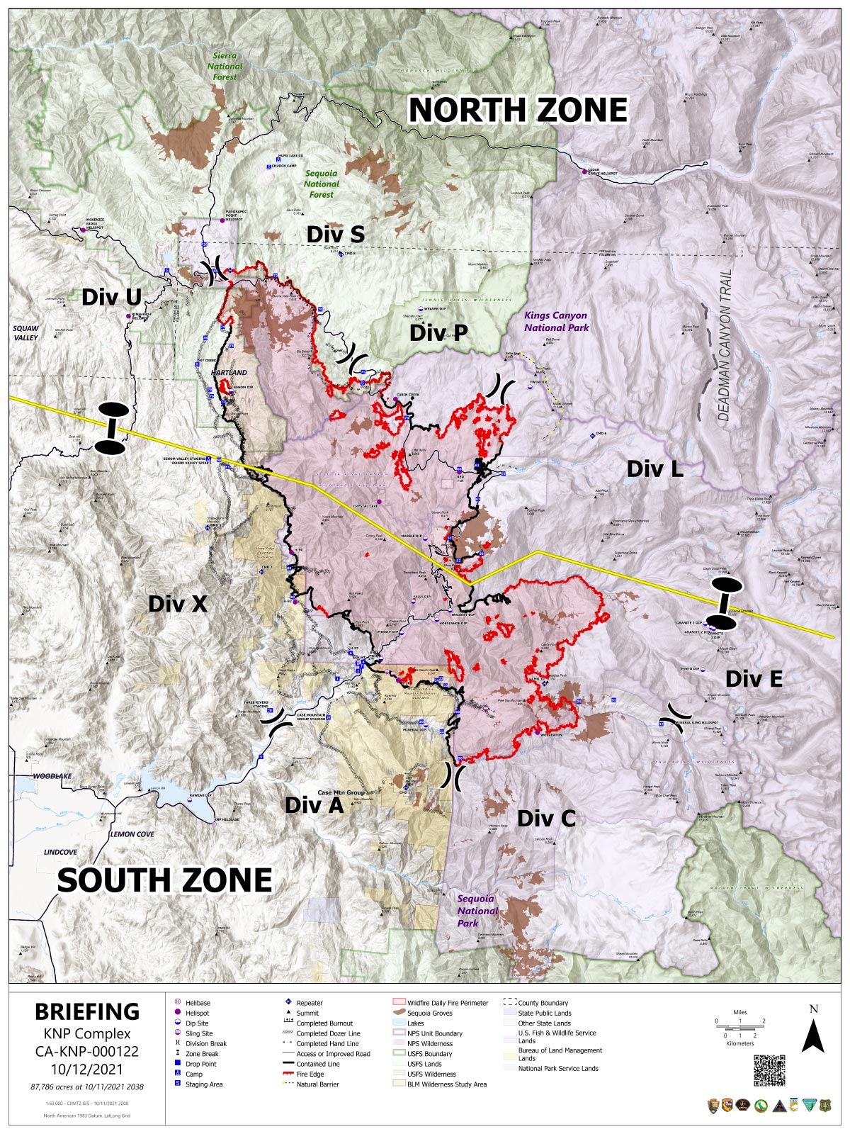
October 12, 2021 - KNP Complex Fire in Sequoia National Park updates for Tuesday: 87,786 Acres with 30% Containment.
Accident Update: On Monday, October 11, 2021, a hand crew member working in the Atwell Grove area was struck and injured by a rolling rock. The crew member was examined by medics on the incident and flown out to the hospital in Visalia for further care. The patient has made contact with their family members and is currently in stable condition.
Overnight Infrared Flight Notes: No flight last night.
Click here for: KNP Complex Wildfires in Sequoia National Park Monday, October 11, 2021 Updates
Tuesday's Briefing Map
Briefing Map Shows Divisions, Uncontrolled Fire Edge, Completed Dozer Lines.
Note: Map is 1,200 pixels wide.