


Includes Mariposa, Oakhurst and Yosemite National Park
Note: Updated Tuesday Morning;
Winter Storm Warning Issued for the Sierra Nevada and Adjacent Foothills Beginning Today Through Early Saturday Morning – Possible 2 Feet of Snowfall from 1,000 to 3,000 Feet – Includes Mariposa, Oakhurst and Up to 3 Feet in Yosemite Valley
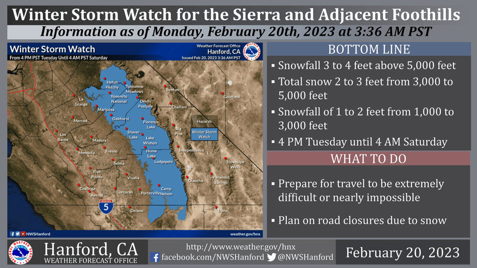
February 20, 2023 - The National Weather Service Hanford Office reports a Winter Storm Watch is in effect for the Sierra Nevada and adjacent foothills from 4:00 P.M. Tuesday afternoon until 4:00 A.M. early Saturday morning.
A Winter Storm Watch means there is potential for significant snow accumulations that may impact travel.
The majority of this snow will fall Wednesday afternoon through Thursday night.
Winds may gust as high as 70 mph on exposed ridgetops and near the crest.
Travel could be extremely difficult or impossible. If you plan to travel, consider alternate strategies. If you must travel, remember to carry tire chains, plenty of food, a good deal of water, warm clothing, and a flashlight in your vehicle.
Winter Storm Watch
URGENT - WINTER WEATHER MESSAGE
National Weather Service Hanford CA
1202 AM PST Mon Feb 20 2023

CAZ318-320-322>331-201700-
/O.NEW.KHNX.WS.A.0005.230222T0000Z-230225T1200Z/
Mariposa-Madera Lower Sierra-Fresno-Tulare Lower Sierra-
South End of the Lower Sierra-Yosemite NP outside of the valley-
Yosemite Valley-San Joaquin River Canyon-Upper San Joaquin River-
Kaiser to Rodgers Ridge-Kings Canyon NP-Grant Grove Area-
Sequoia NP-South End of the Upper Sierra-
Including the cities of Bass Lake, Coarsegold, Fish Camp,
Oakhurst, North Fork, Auberry, Camp Nelson, Tuolumne Meadows,
Wawona, Yosemite Valley, Devils Postpile, Florence Lake,
Lake Thomas Edison, Lake Wishon, Huntington Lake, Shaver Lake,
Cedar Grove, Grant Grove, Hume Lake, Giant Forest, Lodgepole,
and Johnsondale
1202 AM PST Mon Feb 20 2023

...WINTER STORM WATCH IN EFFECT FROM TUESDAY AFTERNOON THROUGH
LATE FRIDAY NIGHT...

* WHAT...Heavy snow possible. 1 to 2 feet of snow accumulation
  from 1,000 to 3,000 feet, 2 to 3 feet of snow accumulation from
  3,000 to 5,000 feet, and 3 to 4 feet of snow accumulation above
  5,000 feet. Winds could gust as high as 70 mph.

* WHERE...The Sierra Nevada and the Foothills.

* WHEN...From Tuesday afternoon through late Friday night.

* IMPACTS...Travel could be very difficult to impossible. Very
  strong winds could cause extensive tree damage. The cold wind
  chills as low as 30 below zero could cause frostbite on exposed
  skin in as little as 30 minutes.

PRECAUTIONARY/PREPAREDNESS ACTIONS...

Monitor the latest forecasts for updates on this situation.
Source: NWS
