


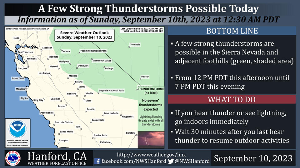
Possible Thunderstorms in the Sierra Nevada and the Foothills of Mariposa, Madera and Fresno Counties Including Yosemite National Park
September 10, 2023 - National Weather Service Hanford Office officials report a few strong thunderstorms are possible in the Sierra Nevada and adjacent foothills from 12:00 P.M. this afternoon until 7:00 P.M. this evening.
Wind gusts near 45 miles per hour and small hail are a couple of hazards associated with strong thunderstorms.
In addition to dangerous cloud to ground lightning strikes, any thunderstorm can produce intense rainfall rates, leading to localized flooding.
Area Forecast Discussion
National Weather Service Hanford CA
200 AM PDT Sun Sep 10 2023
.SYNOPSIS...
The moisture from Tropical Storm Jova that are causing the
showers this morning are expected to linger into the early
afternoon with slight chances for a few thunderstorms across the
Sierra Nevada. These storms will move out of our area completely
by early Monday morning. Dry conditions are expected from Monday
through most of the week. Temperatures are expected to remain
slightly above normal through the weekend before dropping to just
below normal early next week, where they will remain consistent
through the next weekend.
&&
.DISCUSSION...
The influence of Hurricane Jova is still being felt across the
Central California Interior. Showers and thunderstorms continue to
surge across the region. Doppler radar is showing an area of
wide-spread showers currently offshore and heading for Central
California before daybreak. Based on the latest High-Res regional
model, will expected the passage of the wide-spread mainly over
Kern, Kings and Tulare Counties before exiting later this morning.
While thunderstorms will travel across the San Joaquin Valley
today, the higher probability of thunder exist over the higher
terrain of the Tehachapi and Sierra Nevada. Therefore, will
continue to mention a chance of thunderstorms today as moisture
from Jova pushes toward Central California. Ensemble upper-air
analysis has a shift in the steering current early this week to
begin a cooling and drying trend.
Ensemble upper-air analysis still show Hurricane Jova slowly
drifting west by northwest. While the track will shift more
westerly, some moisture will continue to feed into the westerlies
and toward California as seen on water vapor satellite imagery.
Even with the moisture pushing into the region, ensemble surface
temperature analysis shows minimal change toward cooling. NBM
probability of exceedance of reaching 95 degrees still goes above
60 percent this Sunday afternoon. Therefore, will feel warm and
humid going into the early part of the week. Instability and other
convective parameters favor the southern portion of the Central
California Interior along with the Sierra Nevada and Tehachapi
range. Ensemble mean convective parameters trend downward from
today into Monday as a weak piece of energy moves through Northern
California on Monday.
Ensembles upper-air analysis shows higher confidence is having a
disturbance turn the steering current to a more westerly direction
as lower the instability potential. At that point, we begin to
lose the moisture and instability tap as the region begins to dry
out. In addition, the change in the flow from southwesterly to a
more northwesterly direction will allow for a cool down. By
Tuesday, NBM probability of exceedance of reaching 95 degrees
drops to below 30 percent across the San Joaquin Valley. This
trend continues through mid-week.
Longer range ensemble Cluster Analysis still shows a strong signal
toward the building of a ridge pattern over CONUS. Ensemble
Cluster Analysis continues to show minimal error in the timing of
the ridge development but does show some deviation in the
amplitude and position of the ridge. Therefore, some variability
exist on the strength of the ridge pattern and how hot
temperatures can become during the week after the cool down. At
the moment, will keep the longer range period (outside of the
desert) below triple digit readings.
&&
.AVIATION...
A chance of showers and a slight chance of thunderstorms over the
San Joaquin Valley. a chance of thunderstorms over the Sierra
Nevada and Tehachapi range through 03Z Monday. Otherwise, VFR
conditions will prevail across the Central CA interior through the
next 24 hours.
&&
.AIR QUALITY ISSUES...
None.
&&
.CERTAINTY...
The level of certainty for days 1 and 2 is high.
The level of certainty for days 3 through 7 is medium.
Certainty levels include low...medium...and high. Please visit
www.weather.gov/hnx/certainty.html for additional information
and/or to provide feedback.
&&
.HNX WATCHES/WARNINGS/ADVISORIES...
None.
Source: NWS
