


August 20, 2024 - National Weather Service Hanford Office officials report by this weekend, much cooler temperatures arrive.
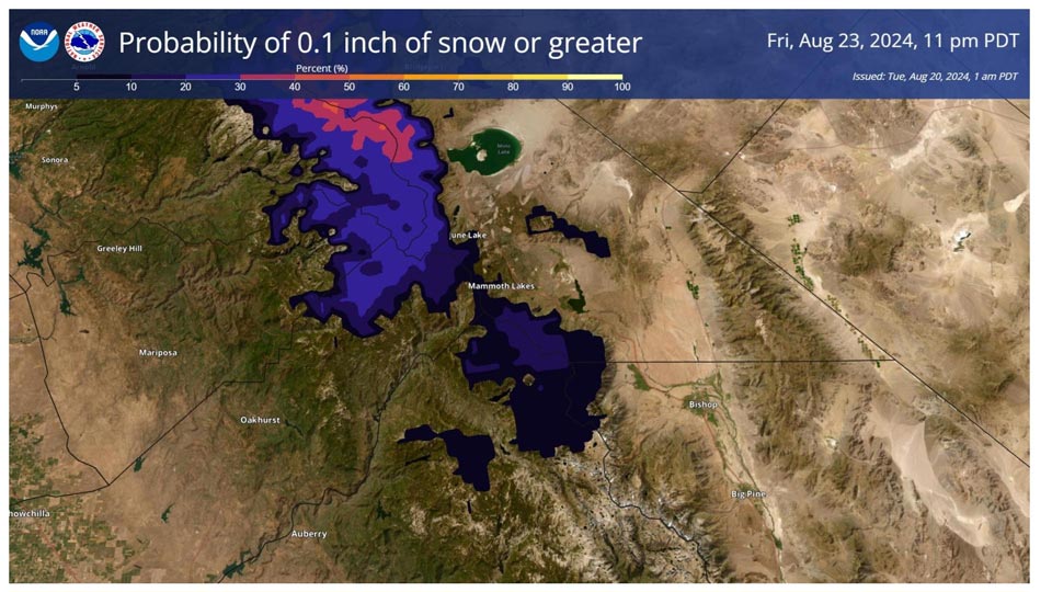
Snow is a possibility in the highest elevations of the Sierra Nevada, mainly towards Yosemite NP, on Friday evening into Saturday.
The latest probabilities shown in the image are around 10 to 30 percent for the highest elevations of the Sierra Nevada from Yosemite to Fresno County.
Snow levels are around 8,000 feet.
Area Forecast Discussion
National Weather Service Hanford CA
251 AM PDT Tue Aug 20 2024
&&
.KEY MESSAGES...
1. Confidence remains high for temperatures to return to near
normal today and Wednesday, with a 50-80% chance for highs of 95
degrees or higher today.
2. The risk of grass fires continues with breezy afternoon
winds. The risk is highest in eastern Kern County due to
elevated winds and relative humidity less than 10 percent.
3. A cooling trend is forecast late in the week with
temperatures lowering to 10-15 degrees below normal on Friday
and Saturday. There is a 40-50% probability of a dusting of snow
on Saturday morning above 8000 feet on the Sierra Nevada crest.
4. Temperatures are expected to quickly rebound to near normal
Sunday with above normal temperatures anticipated for the
following week.
&&
.DISCUSSION...
A ridge centered over New Mexico will continue to have influence
over Central California today, but as we move into Wednesday, it
will be pushed east by a weak trough centered over the west
coast. With this ridge, there is a 50-80% chance for
temperatures to be 95 degrees or higher today, and as it is
pushed out by the trough, these chances dip to 30-50%. A
stronger trough is expected to follow up beginning on Friday,
resulting in temperatures dropping to 10-15 degrees below normal
that day and Saturday. Stronger winds are also expected
throughout the region as the trough passes through.
This trough is also bringing the possibility of a dusting of
late season snow to the Sierra Nevada crest at elevations above
8000 feet. Tioga Pass and Tuolumne Meadows currently seeing a
43% and 34% chance of 0.1 inches of snow respectively from
Friday night through Saturday morning, right as the lowest
portion of the trough goes over the Sierra Nevada crest. The
higher elevations have a 40-50% chance for a dusting of snow as
well.
The trough is expected to exit the area by Sunday, with a ridge
quickly building into it's place. This will cause temperatures
to rise back up to around normal Sunday afternoon. They are
expected to increase further into the above normal territory as
the ridge gains further influence over Central California.
Chances for triple digits return next week, with many locations
in the valley seeing probabilities of 60-80% for highs of 100
degrees or higher.
&&
.AVIATION...
Areas of MVFR and local IFR visibilities will continue in and
around wildfires. Otherwise, VFR conditions will prevail across
the central CA interior over the next 24 hours.
&&
.AIR QUALITY ISSUES...
ISSUED: 08/19/2024 14:46
EXPIRES: 08/20/2024 23:59
None.
&&
.CERTAINTY...
The level of certainty for days 1 and 2 is medium.
The level of certainty for days 3 through 7 is medium.
Certainty levels include low...medium...and high. Please visit
www.weather.gov/hnx/certainty.html for additional information
and/or to provide feedback.
&&
.HNX WATCHES/WARNINGS/ADVISORIES...
None.
Source: NPS

