


California and National Drought Summary for August 27, 2024
Summary
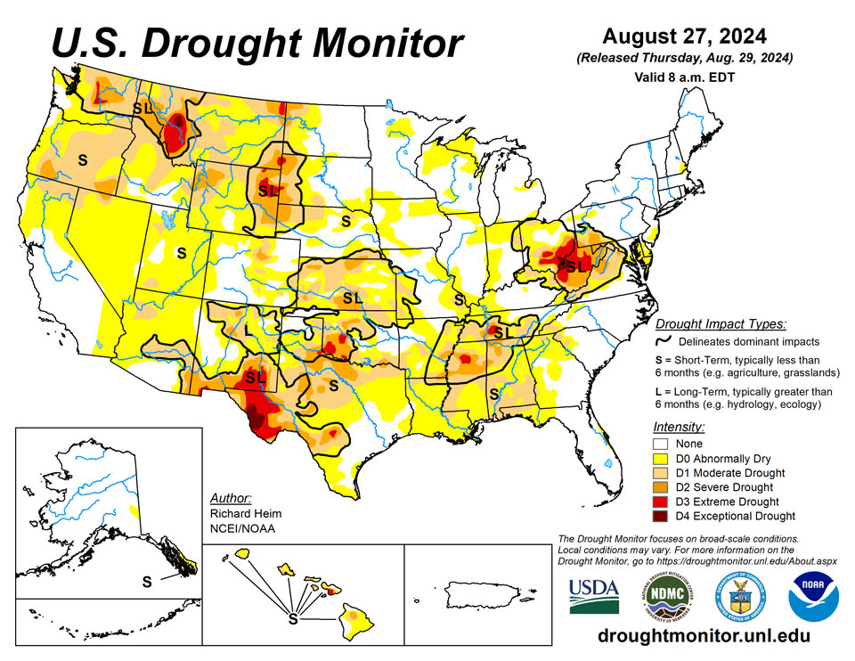
August 29, 2024 - A strong ridge of high pressure maintained its grip across the central part of the contiguous U.S. (CONUS) during this U.S. Drought Monitor (USDM) week (August 21-27). It was responsible for warmer-than-normal temperatures that stretched across the Plains and into the Upper Midwest. Upper-level troughs of low pressure dominated the West and East coasts, keeping weekly temperatures cooler than normal on both ends of the country. Pacific weather systems spread above-normal precipitation over northern California to the Pacific Northwest as they moved through the western trough, then triggered bands of thunderstorms over the Rockies and central to northern Plains as they bumped up against the ridge. In between the West Coast and Rockies rain areas, the West was dry from southern California to northern Montana. Rain developed along a stationary front that was draped across Florida. But for most of the CONUS east of the Rockies, the week was drier than normal with little to no rain falling from western Texas to the Mid-Atlantic Coast. The ridge migrated eastward as the week ended, so warmer-than-normal temperatures spread into the Midwest and Southeast. Abnormal dryness and drought expanded and intensified across the southern Plains and Tennessee and Lower Mississippi Valleys in a rapidly developing flash drought situation, as well as parts of the Southeast, Mid-Atlantic, Midwest, northern Plains, and Far West. Exceptional drought (D4) developed in parts of Ohio and West Virginia for the first time in the 25-year USDM history. Hurricane Hone’s rains brought improvement to most of the main Hawaiian Islands.
Northeast
Northern parts of the Northeast received half an inch or more of rain this week while the rest of the region received little to no rain. Weekly temperatures averaged near normal in Maine to 5 to 8 degrees cooler than normal in West Virginia and Delaware. The spot of abnormal dryness in New Hampshire shrank due to rains from the last 2 weeks, while abnormal dryness expanded in Delaware and eastern Maryland and severe to extreme drought expanded in West Virginia where exceptional drought (D4) was added -- the first time D4 has appeared in West Virginia in the USDM’s history. According to the U.S. Department of Agriculture (USDA), 100% of West Virginia’s topsoil and subsoil moisture was rated short or very short (dry or very dry), and 92% of the pastures and rangeland were in poor to very poor condition. This is a record high percentage of topsoil moisture short or very short in the 22-year record for West Virginia, and a record low statewide pasture and range condition index. Reports have been received of widespread crop loss and water hauling for livestock and irrigation, pastures/meadows not regenerating, low streamflow, and dry soils.
Southeast
Florida and extreme southeast Georgia were peppered with numerous showers and thunderstorms that dropped 2 to 3 inches of rain in many areas, with locally over 5 inches occurring. There were a couple areas of half an inch of rain in other states, but most of the Southeast region received no precipitation this week. Temperatures averaged cooler than normal across much of the region, ranging from 6 to 8 degrees below normal in Virginia and the Carolinas to near to slightly above normal in Florida. Abnormal dryness expanded and moderate drought developed in the western Carolinas, where streams were low and the last 30 days were very dry, and in Florida and Georgia; moderate drought expanded in Virginia; and abnormal dryness and moderate drought expanded and severe drought developed in Alabama. According to the USDA, half or more of the topsoil moisture and subsoil moisture was short or very short in Georgia and Alabama.
South
Hot and dry conditions continued for the South region this week. Western parts of Texas and Oklahoma were the epicenter of the heat, with weekly temperatures averaging 6 to 10 degrees above average, with local areas even warmer. In the east, Arkansas, Mississippi, and Tennessee averaged 2 to 4 degrees cooler than normal. Parts of coastal Texas to the state’s interior received half of an inch to locally 2 inches of rain, but this mostly fell on drought-free areas. Most of the South region had no rain this week. Abnormal dryness and moderate to severe drought expanded in all of the states, while extreme drought expanded in Texas and developed in Oklahoma, Mississippi, and Tennessee. The heat and dryness of this August have resulted in flash drought conditions. Summer last year was a period of record and near-record heat and dryness. These extreme conditions of these two periods have combined to overwhelm the wet conditions that happened during the intervening months. More than half of the topsoil and subsoil moisture was short or very short across all states, with Texas leading at 72% of the subsoil and 81% of the topsoil so rated. More than 70% of the topsoil was short or very short in Louisiana (77%) and Mississippi (72%), and more than 60% so rated in Arkansas (63%) and Tennessee (64%). In Texas, 41% of the cotton crop and 58% of the pasture and rangeland was in poor to very poor condition. Drought impact reports in Oklahoma included desiccated fields, dry ponds, and a high risk of wildfires, as well as low reservoir levels in the southwestern part of the state. In Tennessee, drought impacts include pastures providing little to no feed, drying or dried up ponds, creek levels very low, complete or near crop failure. In Mississippi, 4 counties have burn bans, pastures in the northern half of the state are no longer producing grass for cattle, and soils are so dry they no longer can support vegetation.
Midwest
Average weekly temperatures ranged from 6 to 8 degrees warmer than normal in northwestern parts of the region to 4 to 6 degrees cooler than normal in southeastern parts. Half of an inch to an inch of rain fell over western and northern parts of the Midwest, with locally 2 inches or more in Minnesota, northern Wisconsin, and Upper Michigan. The heaviest rain fell over drought-free areas. But states to the south and east, especially those in the Ohio Valley, received no rain. Abnormal dryness and moderate to extreme drought expanded in Ohio, with exceptional drought being added for the first time in the state’s USDM history. Abnormal dryness expanded in Iowa, Minnesota, and Illinois; abnormal dryness and moderate drought expanded in Missouri; abnormal dryness expanded and moderate drought developed in Indiana; and abnormal dryness and moderate to severe drought expanded in Kentucky. According to USGS data, the Hocking River at Enterprise, Ohio, measured the fifth lowest river level on record, and the lowest measurement ever (since 1997) at Hocking River at Athens. Other drought impact reports include pasture conditions rated poor to very poor with yields dropping to 36%, springs and private wells are running dry, creeks are dry with low ponds, soybeans are not filling pods, there is extensive tip-back in corn, and some farmers are chopping corn plants for feed or selling their cows. USDA statistics indicated that over 70% of the topsoil (75%) and subsoil (71%) was short or very short of moisture in Ohio, and over 40% was so rated in Indiana and Kentucky.
High Plains
Weekly temperatures were warmer than normal across most of the High Plains region, ranging from near to 2 degrees below normal in western Colorado to 6 to 10 degrees above normal in parts of Nebraska and the Dakotas. Thunderstorm complexes moved across parts of the region, dropping locally 2 to 3 inches of rain. In many cases, the storms were localized with one part of a county receiving rain and another part getting nothing – this was the case in other parts of the country as well. Drought or abnormal dryness contracted in a few areas of Colorado, Kansas, Nebraska, and South Dakota, but expanded or intensified in parts of all of the High Plains states. USDA statistics indicate half or more of the topsoil is short or very short in Wyoming (73%), Colorado (52%), and Kansas (52%), and half or more of the subsoil is short or very short in Wyoming (81%) and Kansas (57%).
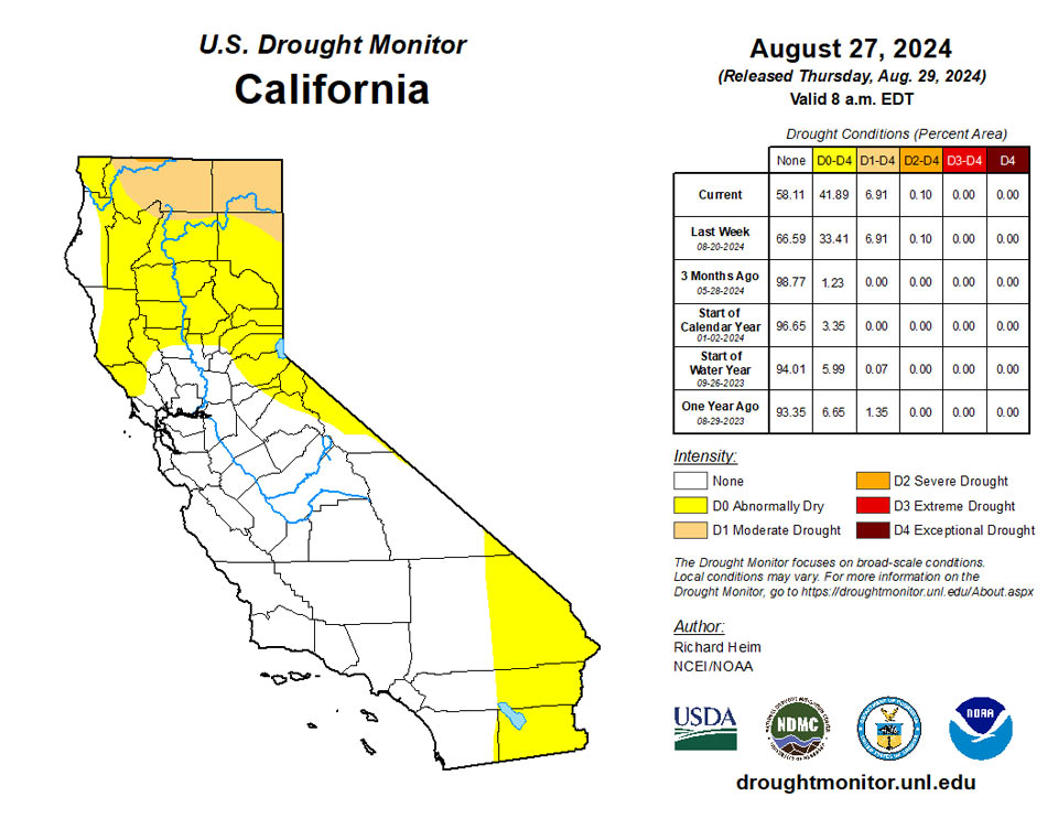
West
Most of the West region was cooler than normal, with temperatures more than 10 degrees below normal across interior portions, especially in Nevada; eastern areas were warmer than normal, up to 6 or more degrees above normal in eastern Montana and eastern New Mexico. More than 2 inches of rain fell over coastal parts of northern California, southern Oregon, and northern Washington, with 0.5 to 2 inches over large parts of the Four Corners states. The rain that fell was not enough to make up for deficits that have accumulated over several months to more than a year, so no improvement to the depiction was made. Abnormal dryness expanded in Nevada and southern California, where little to no rain fell this week, and moderate to extreme drought expanded in Montana. According to USDA statistics, half or more of the topsoil moisture was short or very short in Montana (82%), Oregon (77%), Idaho (68%), Washington (64%), New Mexico (62%), and Nevada (55%), and half or more of the subsoil moisture was short or very short in Montana (82%), Oregon (72%), Nevada (70%), Idaho (64%), Washington (63%), and New Mexico (63%). Half or more of the pasture and rangeland was rated in poor or very poor condition in Oregon (64%), Washington (60%), and Arizona (52%).
Caribbean
Puerto Rico was warmer and mostly drier than normal this week. But last week was wet, so no change was made to the island which remains free of drought and abnormal dryness.
Given heavy rains from Ernesto last week, conditions remained free of drought or abnormal dryness this week in the U.S. Virgin Islands. Well levels at U.S. Geological Survey monitoring sites on each island have remained elevated since last week, though depth-to-water has fallen slightly at the measuring site on St. Thomas. Windswept Beach on St. John received 1.2 inches of rain this week, while a CoCoRaHs observation site east of Cruz Bay received 0.89 inches. On St. Thomas, rainfall amounts from CoCoRaHs observations ranged from 0.41 to 0.71 inches. Rainfall amounts on St. Croix ranged from 0.55 to 1.11 inches.
Pacific
Alaska was mostly cooler than normal and had a mixed precipitation anomaly pattern this week. No change was made to the depiction, so moderate drought continues in southern parts of Alaska’s panhandle.
Hurricane Hone spread heavy rains across parts of Hawaii this week. Rainfall totals of 4+ inches were widespread on the windward side of the Big Island with over a foot of rain reported in favored upslope areas. Hone’s rains reached as far west as Oahu. The Big Island experienced a 1-category improvement in drought conditions and abnormal dryness and drought contracted on Maui, Molokai, and Oahu.
The pattern of drier weather at Pago Pago compared to Siufaga and Toa Ridges continued this week, though rainfall at the two ridge measuring sites has been sufficient the last few weeks to avoid the development of abnormal dryness, despite drier weather this week. Pago Pago recorded 0.57 inches of rain, while Siufaga and Toa Ridges received 0.84 and 0.73 inches.
By the end of the week, Koror had received 1.03 inches. Conditions have been a bit drier recently, but no drought or abnormal dryness has developed.
The Mariana Islands were free of abnormal dryness of drought this week. Saipan Airport reported over 3 inches of rain at the beginning of the reporting period, marking a second consecutive wet week and the end of abnormal dryness. Rainfall on Guam ranged from 0.77 to 2.49 inches this week. Rainfall on Rota totaled 2.29 inches this week.
In Yap, heavier rains fell this week, with 3.45 inches reported. However, the preceding weeks were quite dry, which along with long-term dryness were causing multiple impacts. Thus, Yap was depicted this week as having short- and long-term abnormal dryness. Ulithi reported 0.62 inches of rain this week after a mostly dry last couple of weeks, and short- and long-term abnormal dryness developed. Mostly dry weather occurred in Woleai this week, with only 0.06 inches of rain being reported. However, with recent wet weeks before this, no abnormal dryness has developed. No data were available for Fananu this week, so no Drought Monitor depiction was made there. In Chuuk, 6.99 inches of rain were reported this week. In Lukunor, over 3 inches of rain fell this week, helping to partly refill reservoirs, though short-term abnormal dryness continued. In Nukuoro, only 0.56 inches of rain fell this week, marking the third out of the last four weeks with less than 2 inches of rainfall. Given 3 inches of rain last week, abnormal dryness has not yet developed. In Kapingamarangi, abnormal dryness intensified into short-term moderate drought after only 0.12 inches of rain fell this week. In Pohnpei, 3.1 inches of rain fell, which likely helped to improve conditions. However, given how far below normal August rainfall has been, short-term abnormal dryness continued. In Pingelap, only 0.19 inches of rain fell this week, though with over 4 last week, conditions remained free of abnormal dryness or drought. In Kosrae, 1.76 inches of rain fell, marking the third consecutive week with less than 2 inches of rain. However, given wet conditions in July, abnormal dryness has not yet developed.
In Kwajalein, 1.2 inches of rain were reported this week after 3.56 inches occurred last week, and it remained free of abnormal dryness or drought. In Ailinglapalap, 2.55 inches of rain were reported this week after the previous two weeks saw less than 2 inches of rain, and conditions remained free of drought or abnormal dryness. In Jaluit, only 0.4 inches of rain were reported after 2.87 inches fell last week. While abnormal dryness has not yet developed, conditions have been drying recently there. Wotje received 1 inch of rain this week after 3.08 inches last week, and conditions remained free of abnormal dryness or drought. In Majuro, 0.68 inches of rain fell this week; however, given that over 2 inches fell last week, abnormal dryness has not yet developed. In Utirik and Mili, no data were reported, so no Drought Monitor depiction was made in either location.
Looking Ahead
In the two days since the Tuesday valid time of this USDM, scattered showers and thunderstorms brought areas of rain to a few parts of the Southwest, northern Rockies, northern and southern Plains, Midwest, and Florida, but the rest of the CONUS was mostly dry. For August 29-September 3, an upper-level ridge will build over the West, bringing warmer- and drier-than-normal weather, while a weather system moves across the eastern CONUS and a weather disturbance lingers over the western Gulf of Mexico Coast. An inch or more of rain, with locally over 2 inches, is forecast for the southern Plains to Lower Mississippi Valley, Upper Mississippi Valley, and Carolinas to New York. Four or more inches could fall over parts of the southern Plains, New Mexico, and western Gulf Coast. The rain will help to improve drought conditions in the Deep South and central Appalachians, but won’t be enough to end the drought. The Rockies to West Coast, and western High Plains, are forecast to receive no precipitation during this period.
For much of the next 2 weeks, a ridge will remain anchored over the West with a trough along the East Coast, while a couple weather systems try to move through this upper-level blockade. The Climate Prediction Center’s (CPC) 6-10 Day Outlook (valid September 3-7) and 8-14 Day Outlook (valid September 5-11) favor warmer-than-normal temperatures across the West, central and northern Plains, along the Gulf of Mexico Coast, and over the eastern half of Alaska, with near to cooler-than-normal temperatures expected over parts of the southern Plains and from the Ohio Valley to East Coast. Odds favor below-normal precipitation across most of the West, the northern tier states, the Midwest, the northern and central Plains, and Hawaii. Odds favor above-normal precipitation across the Gulf of Mexico Coast to the Carolinas, and over eastern Alaska.
Author(s):
Richard Heim, NOAA/NCEI
Curtis Riganti, National Drought Mitigation Center
Dryness Categories
D0 Abnormally Dry—used for areas showing dryness but not yet in drought, or for areas recovering from drought.
Drought Intensity Categories
D1 Moderate Drought
D2 Severe Drought
D3 Extreme Drought
D4 Exceptional Drought
Drought or Dryness Types
S Short-term, typically less than 6 months (agriculture, grasslands)
L Long-term, typically more than 6 months (hydrology, ecology)
SL Area contains both short- and long-term impacts
Source: National Drought Mitigation Center

