


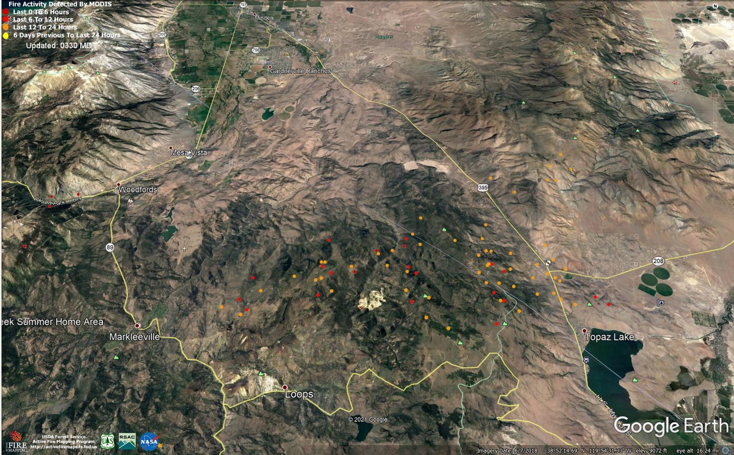
MODIS map of the Tamarack Fire in Alpine County on Saturday at 2:30 A.M PST
Note: 1,500 Pixels Wide
MODIS Active Fire Mapping Program Frequently Asked Questions
Note: California Governor Gavin Newsom Proclaims State of Emergency in Plumas, Butte, Lassen and Alpine Counties Due to Fires - Dixie Fire, Fly Fire and Tamarack Fire
And
Congressman Tom McClintock’s Letter to Chief of the U.S. Forest Service Requesting Answers as to Why There Was a Lack of Suppression Action to Combat the Tamarack Fire in Alpine County
And
Congressman Tom McClintock Requests California Governor Gavin Newsom Declare a State of Emergency for the Tamarack Fire in Alpine County
Click Here for Sunday Information
Evening Update: The Tamarack Fire is now at 66,744 Acres with 4% Containment.
Basic Information
| Current as of | 7/24/2021, 6:15:19 PM |
| Incident Type | Wildfire |
| Cause | Lightning |
| Date of Origin | Sunday July 04th, 2021 approx. 04:00 PM |
| Location | 16 Miles south of Gardnerville, NV |
| Incident Commander | Dan Dallas, IC Bill Hahnenberg, Deputy IC |
| Coordinates | 38.628 latitude, -119.857 longitude |
Current Situation
| Total Personnel | 1,557 |
| Size | 66,744 Acres |
| Percent of Perimeter Contained | 4% |
| Estimated Containment Date | Tuesday August 31st, 2021 approx. 12:00 AM |
| Fuels Involved |
Timber (Grass and Understory) Chaparral (6 feet) Timber (Litter and Understory) |
| Significant Events |
Extreme Crowning Short Crown Runs Uphill Runs Fire is burning in mixed conifer, Pinyon Juniper and brush fuel types, with high rates of spread. Crowning, torching, and running fire behavior with short/ midrange spotting. |
Outlook
| Planned Actions |
Branch I - Hold fire south of China Spring. Secure Hwy 395 slopover. Secure structures along Hwy 395, Topaz Ranch Estates, and Topaz Lake. Branch II - Keep fire north of Highway 89, monitor pass between Hwy 395 and Hwy 4. Branch III - Hold fire south of Hwy 88. Secure structures in Crystal Springs. Hold fire east of Rocky Spine Ridge. Structure - Secure structures along Hwy 395, Spring Valley, and Holbrook. Night Operations - Patrol and secure structures along Hwy 88 and Hwy 395. Conduct firing operations as conditions allow (BR I and III). |
| Projected Incident Activity |
12 hours: Active fire behavior. Crown fire runs in heavy fuels. 24 hours: Continued active fire behavior. Fire spread is primarily backing and flanking to the south. Possible strong outdrafts from nearby thunderstorms may affect the fire. |
| Remarks |
Acreage estimated from FireWatch flight: 1319 7/24/2021 |
Current Weather
| Weather Concerns |
Today's weather was mostly sunny. High Temps 79-89. Min RH 15-20%. Mostly sunny. Upslope 4-8 mph with NW 10-15 G25 late in the afternoon and evening mainly on the Nevada side. HAINES 5 Tonight-Clear with smoke. Min Temp 50-60. Max humidity around 35-45%. Localized downcanyon winds. Sunday-Partly cloudy, becoming mostly cloudy with a chance of thunderstorms and gusty outflow winds. High Temps 79-89. Min RH 15-20%. Upslope 4-8 mph with WSW 10-15 G25 late in the afternoon and evening. HAINES 4 |
Flying aircraft? Know before you go...
The Tamarack Fire has experienced multiple incursions on the Temporary Flight Restriction (TFR) in place. These TFRs limit other aircraft from flying within its perimeter, providing a safe environment for aerial firefighting operations.
Whether flying a fixed wing, helicopter, or drone… private aircraft must abide by these TFR regulations. If aircraft encroaches on the TFR, it can be deadly. Any personal aircraft, even a tiny drone, can cause a serious or fatal accident if it collides with firefighting aircraft. If aircraft or drones are spotted near a wildfire, firefighting aircraft must land due to safety concerns. This prolongs firefighting operations; in many cases, wildfires become larger when aircraft are not able to drop fire retardant, water, monitor wildfires from above, or provide tactical information to firefighters. Homes and other values at risk could burn needlessly, firefighters or others could be injured, or worst of all, a fatal accident could occur.
Per the U.S. Code of Federal Regulations, 43 CFR 9212.1(f), it is illegal to resist or interfere with the efforts of firefighter(s) to extinguish a fire. Doing so can result in a significant fine and/or a mandatory court appearance No trip or photos are worth the consequences.
Please help us keep our firefighters and pilots safe by checking before you fly. If you fly… we can’t!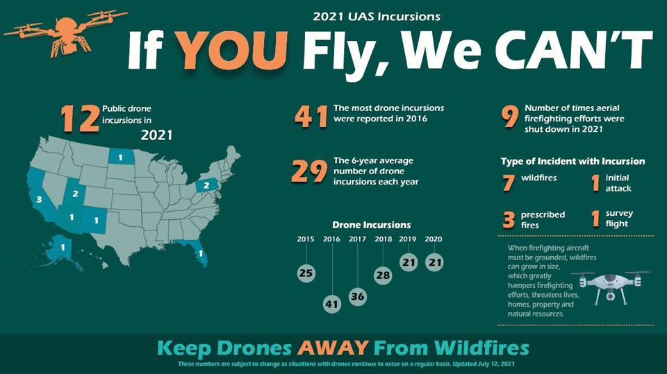
Update: 9:20 A.M. Sheriffs escort evacuated residents, Sat, July 24 (pdf 146 kb)
July 24, 2021 - The Tamarack Fire as of Saturday morning is now at 65,152 Acres with 4% Containment.
Basic Information
| Current as of | 7/24/2021, 4:46:15 AM |
| Incident Type | Wildfire |
| Cause | Lightning |
| Date of Origin | Sunday July 04th, 2021 approx. 04:00 PM |
| Location | 16 Miles south of Gardnerville, NV |
| Incident Commander | Dan Dallas, IC Bill Hahnenberg, Deputy IC |
| Coordinates | 38.628 latitude, -119.857 longitude |
Current Situation
| Total Personnel | 1,425 |
| Size | 65,152 Acres |
| Percent of Perimeter Contained | 4% |
| Estimated Containment Date | Tuesday August 31st, 2021 approx. 12:00 AM |
| Fuels Involved |
Timber (Grass and Understory) Chaparral (6 feet) Timber (Litter and Understory) |
| Significant Events |
Active Crowning Short Crown Runs Uphill Runs Fire is burning in mixed conifer, Pinyon-Juniper and brush fuel types with high rates of spread. Crowning, torching, and running fire behavior. Short and mid-range spotting is prolific in lower elevation fuels. |
Outlook
| Planned Actions |
Branch I - Hold fire south of China Spring. Secure Hwy 395 slopover. Secure structures along Hwy 395, Topaz Ranch Estates, and Smith Valley. Branch II - continue to scout indirect Line opportunities from Leviathan Peak west to Q/T break. Branch III - Hold fire south of Hwy 88. Secure structures in Crystal Springs. Hold fire east of Rocky Spine Ridge. Structure - Secure structures along Hwy 395, Spring Valley, and Holbrook. Night Operations - Patrol and secure structures along Hwy 88 and Hwy 395. Conduct firing operations as conditions allow (BR I and III). |
| Projected Incident Activity |
12 hours: Very active to extreme fire behavior. High rates of spread with torching and spotting associated with brush and Pinyon-Juniper fuel types. 24 hours: Continued extreme to active fire behavior. Fire spread primarily to the East. |
| Remarks |
Acreage estimated from NIROPS flight: 1930 7/22/2021 |
Current Weather
| Weather Concerns |
Today's weather was mostly sunny. High Temps 79-89. Min RH 15-20%. Mostly sunny. Upslope 4-8 mph with NW 10-15 G25 late in the afternoon and evening mainly on the Nevada side. HAINES 5 Tonight-Clear with smoke. Min Temp 50-60. Max humidity around 35-45%. Localized downcanyon winds. Saturday-Mostly sunny. High Temps 79-89. Min RH 15-20%. Upslope 4-8 mph with NW 10-15 G25 late in the afternoon and evening mainly on the Nevada side. HAINES 5 |
Click Here for Tamarack Fire in Alpine County Updates for Friday, July 23, 2021
