


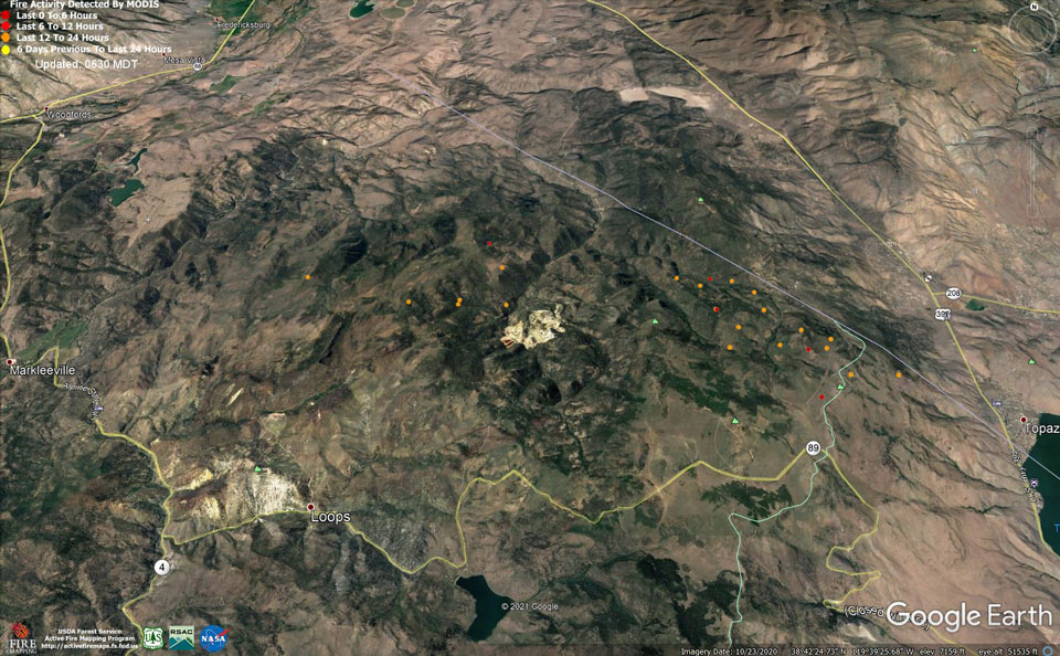
MODIS map of the Tamarack Fire in Alpine County on Sunday at 5:30 A.M PST
Note: 1,500 Pixels Wide
MODIS Active Fire Mapping Program Frequently Asked Questions
Click here for Monday Information
Evening Update: The Tamarack Fire as of Sunday evening is at 66,744 Acres with 27% Containment.
Basic Information
| Current as of | 7/25/2021, 5:59:43 PM |
| Incident Type | Wildfire |
| Cause | Lightning |
| Date of Origin | Sunday July 04th, 2021 approx. 04:00 PM |
| Location | 16 Miles south of Gardnerville, NV |
| Incident Commander | Dan Dallas, IC Bill Hahnenberg, Deputy IC |
| Coordinates | 38.628 latitude, -119.857 longitude |
Current Situation
| Total Personnel | 1,623 |
| Size | 66,744 Acres |
| Percent of Perimeter Contained | 27% |
| Estimated Containment Date | Tuesday August 31st, 2021 approx. 12:00 AM |
| Fuels Involved |
Timber (Grass and Understory) Chaparral (6 feet) Timber (Litter and Understory) |
| Significant Events |
Active Crowning Short Crown Runs Uphill Runs Fire is burning in mixed conifer, Pinyon Juniper and brush fuel types, with high rates of spread. Crowning, torching, and running fire behavior with short/ midrange spotting. |
Outlook
| Planned Actions |
Branch I - Hold fire south of China Spring. Secure Hwy 395 slopover. Secure structures along Hwy 395, Topaz Ranch Estates, and Topaz Lake. Branch II - Keep fire north of Highway 89, monitor pass between Hwy 395 and Hwy 4. Branch III - Hold fire south of Hwy 88. Secure structures in Crystal Springs. Hold fire east of Rocky Spine Ridge. Structure - Secure structures along Hwy 395, Spring Valley, and Holbrook. Night Operations - Patrol and secure structures along Hwy 88 and Hwy 395. Conduct firing operations as conditions allow (BR I and III). |
| Projected Incident Activity |
12 hours: Active fire behavior. Primarily backing and flanking fire. Outflow winds from thunderstorms could cause erratic and extreme fire behavior. 24 hours: Continued active fire behavior. Fire spread is primarily backing and flanking to the south. |
| Remarks |
Acreage estimated from FireWatch flight: 1319 7/24/2021 |
Current Weather
| Weather Concerns |
Today's weather was mostly cloudy with scattered showers and thunderstorms. High Temps 79-89. Min RH 20%. Upslope 4-8 mph with gusty outflow winds over the fire area today with gusts up to 45 mph. Tonight-Clear with smoke. Min Temp 50-60. Max humidity around 45-55%. Localized downcanyon winds. Monday-Partly cloudy, becoming mostly cloudy with numerous thunderstorms and potential for heavy rains. High Temps 78-88. Min RH 25-35%. Upslope 4-8 mph with WSW 8-13 G20 in the afternoon and evening. HAINES 4 |
Update 2:55 P.M. Douglas County Update on Evacuations & Road Closure (pdf 186 kb)
Update 2:15 P.M. Alpine County lifts some Mandatory Evacuations7/25 (pdf 271 kb)
And
Returning Home After Evacuations 7.25.21 (pdf 113 kb)
Update 1:35 P.M. Per Caltrans: U.S. 395 is now open from State Route 89 to the junction of NV 208 at Holbrook Junction. 395 remains closed north of Holbrook Junction due to the #TamarackFire. State Route 89/Monitor Pass is still closed.
Update 9:00 A.M. Sheriffs Escorting Evacuated Residents July 25 (pdf 146 kb)
July 25, 2021 - The Tamarack Fire as of Sunday morning is now at 66,744 Acres with 27% Containment.
Tamarack Fire Update Sunday, July 25, 2021 – 9:00 a.m.
Rocky Mountain Type 1 Incident Management Team Dan Dallas, Incident Commander
Information Phones: 775-434-8629 (public), 775-434-8110 (media only)
Email: 2021.tamarack@firenet.gov
Information Staffing Hours: 8 a.m. to 8 p.m.
Special Notes: Smoke from the Dixie Fire has moved into the area and will affect visibility and air quality throughout the weekend. Air Operations may be impacted. Air quality may be unhealthy for those who are sensitive to smoke.
Current Situation:
Containment of the Tamarack Fire has jumped to 27% today. This follows a second consecutive day in which conditions allowed firefighters to directly engage the edge of the fire on several fronts. Crews will work to continue that progress today, with the 395 corridor and the southern edge of the fire among the top priorities. Challenges include smoke coming from the Tamarack Fire and the Dixie Fire, which is burning to the northwest. Reduced visibility could limit the use of firefighting aircraft. There is also the potential for severe winds and lightning caused by thunderstorms moving into the area this afternoon.
Yesterday, Alpine County removed the mandatory evacuation order for the Mesa Vista community. The estimated number of people of evacuated is now 2289. Incident personnel and local authorities continue to meet daily to assess the fire, its impact on communities and infrastructure, and the status of evacuations.
Closures: Hwys 88, 89 and 4 remain closed in the fire area to all traffic except incident personnel. A portion of Hwy 395 also remains closed for firefighter and public safety.
Branch I: Division K Firefighters working from west to east along the northern edge of the fire completed a new stretch of containment line from the Carson River east to Bryant Creek yesterday. Another crew that started from the east at Hwy 395 continued their work westward. Today, both crews will continue to work towards each other, with the goal of fully containing the entire northern edge of the fire. In the Spring Valley area, firefighters will work to put out hot spots and secure fireline around the community.
In Division L, crews continue efforts to contain the slopover fire that spilled across Hwy 395 last week. Firefighters are “going direct”, meaning they are working right on edge of the fire. They are being supported by helicopters, which drop buckets of water to cool the edge and slow down fire activity.
Firefighters with Division O are also helping with the effort to secure the southern portion of the slopover, east of 395. They made good progress up to the northeast corner yesterday, and will monitor the line today, making sure it holds. Crews also are working in and around Holbrook, where there is still active fire. Fuels remain critically dry, and firefighters are being diligent in efforts to extinguish hot spots and ensure that fireline is secure. Further south, containment has been added to the eastern edge of the fire along Hwy 395, north of Topaz Lake. Structure protection crews continue to work day and night along the 395 corridor to keep fire from impacting neighborhoods in the area.
Division Q The southern edge of the fire is one of the top priorities for firefighters. Yesterday, crews directly engaged the fire, starting at Hwy 395, working to the west. They are using a combination of burnout operations, hand crews directly engaging the edge and aerial resources. Aerial support today may be limited because of smoke that has pushed over the fire area from the Dixie Fire, which reduces visibility. Fire managers continue to assess their options, and they also have a plan in place to develop contingency line further south along the Hwy 89 corridor, if needed.
Branch II: To the south, the fire continues to burn in steep, hard-to reach terrain with slow, limited movement. Staff is being added to Division T today. Firefighters there are scouting locations to insert crews to help secure the southwest corner of the fire. Division Z remains unstaffed. As resources become available, work to establish fireline will be implemented. Monitoring of the divisions from the air continues.
Branch III: Division A has been unstaffed, but, as firefighters finish work securing fireline in Division O, they will shift down to Division A. Where safe to do so, hand crews will directly engage the fire to establish containment.
In Division F, firefighters secured the northwest corner of the fire. Containment was added from Crystal Springs south to an area below Hawkins peak, building on containment line previously established on the northern edge. Crews also completed containment on a stretch leading further south to Burnside Lake. Today, firefighters are working to address a few small, but hard to access stretches of uncontained fire along the western side of the fire. When this work is completed, they’ll move south into Division A to help with containment efforts. Structure protection crews are out again today and tonight, patrolling communities including Sierra Pines, Crystal Springs, Woodfords Markleeville and Grover Hot Springs.
Weather & Fuel Conditions:
Smoke will shade the area today, while expected thunderstorms may bring severe winds and lightning. Much of the smoke comes from the Dixie Fire, burning to the northwest. The smoke could limit the use of firefighting aircraft due to limited visibility. High temperatures will reach 82-92 degrees, with humidity levels at 15-20%. Mild, terrain-driven winds will last until mid-afternoon, when an expected storm system moves in south of the fire area. The chance for significant rainfall is 10%, but there is the potential for outflow winds from the storm pushing strong gusts up to 45 mph over the fire area and increasing fire activity.
There have been incursions into the fire’s Temporary Flight Restriction (TFR) area by aircraft not associated with the Tamarack Fire. TFR violations can disrupt aerial firefighting operations, and may force fire managers to ground essential aircraft. Wildfires are a no-fly zone for unauthorized aircraft, including drones. If you fly, we can’t. For more information, visit http://knowbeforeyoufly.org.
Evacuations, Closures, and Fire Restrictions:
For evacuation notice specifics in Alpine and Douglas Counties visit: https://www.alpinecountyca.gov/AlertCenter.aspx?AID=EVACUATION-INFORMATION-53 and
For road closure specifics visit https://roads.dot.ca.gov/ and https://nvroads.com/.
For closures and fire restrictions on National Forest lands, visit
https://www.fs.usda.gov/detail/htnf/alerts-1069notices/?cid=fseprd573309
Basic Information
| Current as of | 7/25/2021, 7:55:25 AM |
| Incident Type | Wildfire |
| Cause | Lightning |
| Date of Origin | Sunday July 04th, 2021 approx. 04:00 PM |
| Location | 16 Miles south of Gardnerville, NV |
| Incident Commander | Dan Dallas, IC Bill Hahnenberg, Deputy IC |
| Coordinates | 38.628 latitude, -119.857 longitude |
Current Situation
| Total Personnel | 1,557 |
| Size | 66,744 Acres |
| Percent of Perimeter Contained | 27% |
| Estimated Containment Date | Tuesday August 31st, 2021 approx. 12:00 AM |
| Fuels Involved |
Timber (Grass and Understory) Chaparral (6 feet) Timber (Litter and Understory) |
| Significant Events |
Extreme Crowning Short Crown Runs Uphill Runs Fire is burning in mixed conifer, Pinyon Juniper and brush fuel types, with high rates of spread. Crowning, torching, and running fire behavior with short/ midrange spotting. |
Outlook
| Planned Actions |
Branch I - Hold fire south of China Spring. Secure Hwy 395 slopover. Secure structures along Hwy 395, Topaz Ranch Estates, and Topaz Lake. Branch II - Keep fire north of Highway 89, monitor pass between Hwy 395 and Hwy 4. Branch III - Hold fire south of Hwy 88. Secure structures in Crystal Springs. Hold fire east of Rocky Spine Ridge. Structure - Secure structures along Hwy 395, Spring Valley, and Holbrook. Night Operations - Patrol and secure structures along Hwy 88 and Hwy 395. Conduct firing operations as conditions allow (BR I and III). |
| Projected Incident Activity |
12 hours: Active fire behavior. Crown fire runs in heavy fuels. 24 hours: Continued active fire behavior. Fire spread is primarily backing and flanking to the south. Possible strong outdrafts from nearby thunderstorms may affect the fire. |
| Remarks |
Acreage estimated from FireWatch flight: 1319 7/24/2021 |
Current Weather
| Weather Concerns |
Today's weather was mostly sunny. High Temps 79-89. Min RH 15-20%. Mostly sunny. Upslope 4-8 mph with NW 10-15 G25 late in the afternoon and evening mainly on the Nevada side. HAINES 5 Tonight-Clear with smoke. Min Temp 50-60. Max humidity around 35-45%. Localized downcanyon winds. Sunday-Partly cloudy, becoming mostly cloudy with a chance of thunderstorms and gusty outflow winds. High Temps 79-89. Min RH 15-20%. Upslope 4-8 mph with WSW 10-15 G25 late in the afternoon and evening. HAINES 4 |
Note: California Governor Gavin Newsom Proclaims State of Emergency in Plumas, Butte, Lassen and Alpine Counties Due to Fires - Dixie Fire, Fly Fire and Tamarack Fire
And
Congressman Tom McClintock’s Letter to Chief of the U.S. Forest Service Requesting Answers as to Why There Was a Lack of Suppression Action to Combat the Tamarack Fire in Alpine County
And
Congressman Tom McClintock Requests California Governor Gavin Newsom Declare a State of Emergency for the Tamarack Fire in Alpine County
Click Here for Tamarack Fire in Alpine County Updates for Saturday, July 24, 2021
