


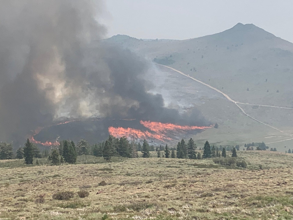
Burn Operation in SE Portion of Tamarack Fire on Sunday
Credit: USFWS
Click here for Tuesday Information
Evening Update: The Tamarack Fire is now at 68,103 Acres, with 54% Containment as of Monday evening.
Basic Information
| Current as of | 7/26/2021, 6:03:08 PM |
| Incident Type | Wildfire |
| Cause | Lightning |
| Date of Origin | Sunday July 04th, 2021 approx. 04:00 PM |
| Location | 16 Miles south of Gardnerville, NV |
| Incident Commander | Dan Dallas, IC Bill Hahnenberg, Deputy IC |
| Coordinates | 38.628 latitude, -119.857 longitude |
Current Situation
| Total Personnel | 1,505 |
| Size | 68,103 Acres |
| Percent of Perimeter Contained | 54% |
| Estimated Containment Date | Tuesday August 31st, 2021 approx. 12:00 AM |
| Fuels Involved |
Timber (Grass and Understory) Chaparral (6 feet) Timber (Litter and Understory) |
| Significant Events |
Active Uphill Runs Flanking Backing Fire is burning in mixed conifer, Pinyon Juniper and brush fuel types, with high rates of spread still possible. Torching, and running fire behavior with short range spotting. |
Outlook
| Planned Actions |
Branch I - Hold fire south of China Spring. Secure Hwy 395 slopover. Secure structures along Hwy 395, Topaz Ranch Estates, and Topaz Lake. Continue right sizing organization. Branch II - Keep fire north of Highway 89, monitor pass between Hwy 395 and Hwy 4. Continue right sizing organization. Branch III - Hold fire south of Hwy 88. Secure structures in Crystal Springs. Hold fire east of Rocky Spine Ridge. Continue right sizing organization. Structure - Secure structures along Hwy 395, Spring Valley, Holbrook, Topaz Ranch Estates, and Topaz Lake. Continue right sizing organization. Night Operations - Patrol and secure structures in all Branches. |
| Projected Incident Activity |
12 hours: Primarily backing and flanking fire. Outflow winds from thunderstorms could cause erratic and extreme fire behavior. 24 hours: Fire spread is primarily backing and flanking to the south. |
| Remarks |
Acreage estimated from FireWatch flight: 1349 7/26/2021 |
Current Weather
| Weather Concerns |
Today's weather was mostly cloudy with scattered showers and thunderstorms. High Temps 79-89. Min RH 20%. Upslope 4-8 mph with gusty outflow winds over the fire area today with gusts up to 45 mph. Tonight-Clear with smoke. Min Temp 50-60. Max humidity around 45-55%. Localized downcanyon winds. Monday-Partly cloudy, becoming mostly cloudy with numerous thunderstorms and potential for heavy rains. High Temps 78-88. Min RH 25-35%. Upslope 4-8 mph with WSW 8-13 G20 in the afternoon and evening. HAINES 4 |
Update 2:30 P.M. Flash Flood Warning Issued for Douglas County (pdf 198 kb)
Update 2:26 P.M. Alpine County Sheriff Announces Changes in Evacuations
Alpine Notice on Mandatory Evacuations July 26, 20 (pdf 151 kb)
Update 1:22 P.M. Evacuation lifted for Spring Valley Holbrook Areas (pdf 186 kb)
Update 9:20 A.M. Per Mono County Tourism: U.S. 395 is back open from its closure due to the Tamarack Fire. Hwy 89 (Monitor Pass) remains closed but Hwy 108 (Sonora Pass) is open
Update 7:52 A.M.: Smoke/Air Quality Outlook for the Tamarack Fire in Alpine County for Monday, July 26
July 26, 2021 - The Tamarack Fire as of Monday morning is now at 67,764 Acres with 45% Containment.
Basic Information
| Current as of | 7/26/2021, 6:50:54 AM |
| Incident Type | Wildfire |
| Cause | Lightning |
| Date of Origin | Sunday July 04th, 2021 approx. 04:00 PM |
| Location | 16 Miles south of Gardnerville, NV |
| Incident Commander | Dan Dallas, IC Bill Hahnenberg, Deputy IC |
| Coordinates | 38.628 latitude, -119.857 longitude |
Current Situation
| Total Personnel | 1,623 |
| Size | 67,764 Acres |
| Percent of Perimeter Contained | 45% |
| Estimated Containment Date | Tuesday August 31st, 2021 approx. 12:00 AM |
| Fuels Involved |
Timber (Grass and Understory) Chaparral (6 feet) Timber (Litter and Understory) |
| Significant Events |
Active Crowning Short Crown Runs Uphill Runs Fire is burning in mixed conifer, Pinyon Juniper and brush fuel types, with high rates of spread. Crowning, torching, and running fire behavior with short/ midrange spotting. |
Outlook
| Planned Actions |
Branch I - Hold fire south of China Spring. Secure Hwy 395 slopover. Secure structures along Hwy 395, Topaz Ranch Estates, and Topaz Lake. Branch II - Keep fire north of Highway 89, monitor pass between Hwy 395 and Hwy 4. Branch III - Hold fire south of Hwy 88. Secure structures in Crystal Springs. Hold fire east of Rocky Spine Ridge. Structure - Secure structures along Hwy 395, Spring Valley, and Holbrook. Night Operations - Patrol and secure structures along Hwy 88 and Hwy 395. Conduct firing operations as conditions allow (BR I and III). |
| Projected Incident Activity |
12 hours: Active fire behavior. Primarily backing and flanking fire. Outflow winds from thunderstorms could cause erratic and extreme fire behavior. 24 hours: Continued active fire behavior. Fire spread is primarily backing and flanking to the south. |
| Remarks |
Acreage estimated from FireWatch flight: 1319 7/24/2021 |
Current Weather
| Weather Concerns |
Today's weather was mostly cloudy with scattered showers and thunderstorms. High Temps 79-89. Min RH 20%. Upslope 4-8 mph with gusty outflow winds over the fire area today with gusts up to 45 mph. Tonight-Clear with smoke. Min Temp 50-60. Max humidity around 45-55%. Localized downcanyon winds. Monday-Partly cloudy, becoming mostly cloudy with numerous thunderstorms and potential for heavy rains. High Temps 78-88. Min RH 25-35%. Upslope 4-8 mph with WSW 8-13 G20 in the afternoon and evening. HAINES 4 |
Click Here for Tamarack Fire in Alpine County Updates for Sunday, July 25, 2021
Note: California Governor Gavin Newsom Proclaims State of Emergency in Plumas, Butte, Lassen and Alpine Counties Due to Fires - Dixie Fire, Fly Fire and Tamarack Fire
And
Congressman Tom McClintock’s Letter to Chief of the U.S. Forest Service Requesting Answers as to Why There Was a Lack of Suppression Action to Combat the Tamarack Fire in Alpine County
And
Congressman Tom McClintock Requests California Governor Gavin Newsom Declare a State of Emergency for the Tamarack Fire in Alpine County
