


Click Here for Tuesday Updates
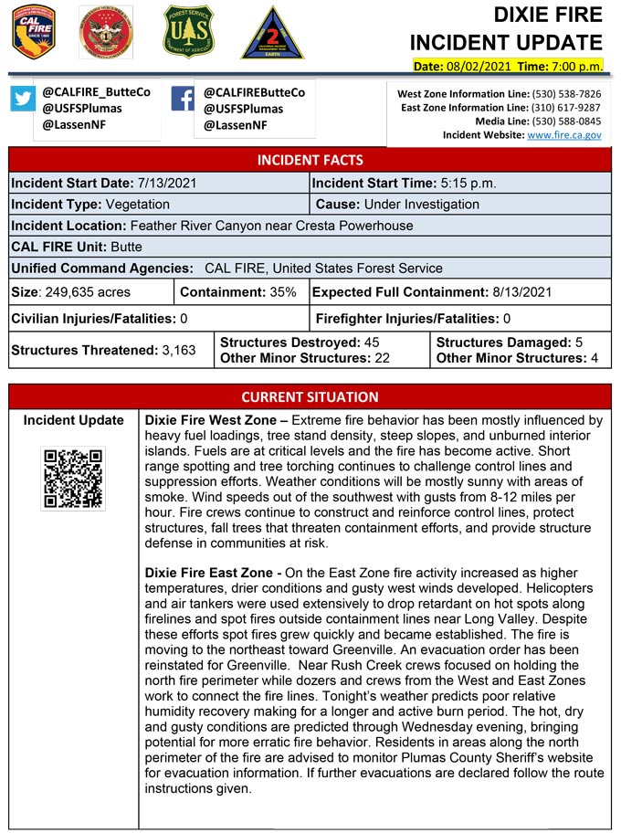
Evening Update Per CAL FIRE: Dixie Fire in Butte County and Plumas County is 249,635 acres and 35% contained for Monday evening.
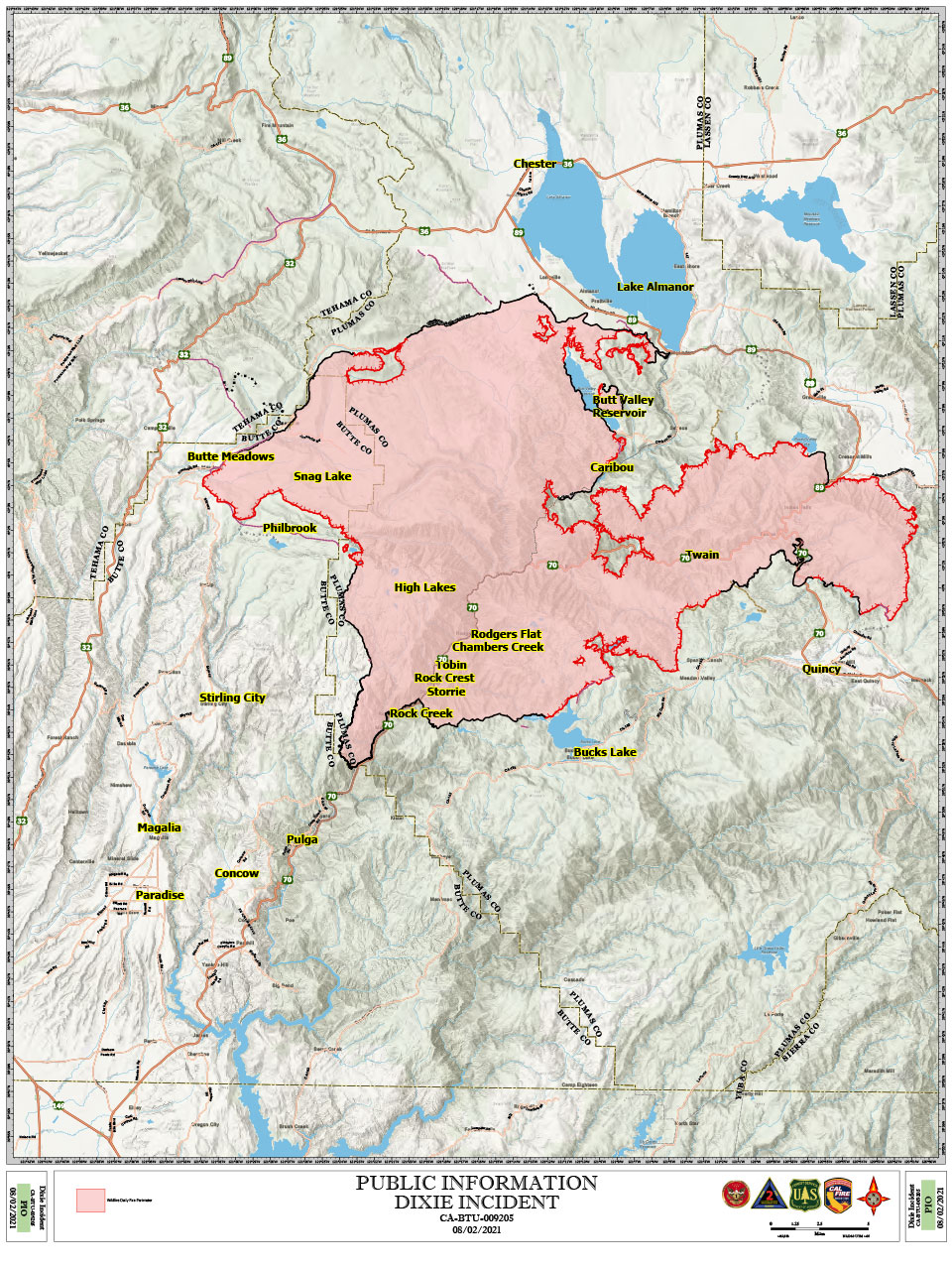
Dixie Fire Public Information Map for Monday, August 2, 2021
Update: Dixie Fire East Zone Operations Evening Briefing Video for Monday, August 2, 2021
Update: Dixie Fire Update Video for Highway 70 on Monday, August 2, 2021
Update Per Plumas County Sheriff's Office: Sheriff's Office orders Mandatory Evacuation Order for Greenville. Leave Area Immediately.
Update Per Plumas County Sheriff's Office: As of 8-2-2021 at 7:20 P.M., per Sheriff Johns, after further evaluating the fire, its progression and current position, Crescent Mills is NOT included in the Mandatory Evacuation Order and is to only remain in a Warning at this time. The map will take some time to be changed. Thank you!
Update Per Plumas County Sheriff's Office: TRAFFIC ALERT: The following closures have been put in place due to the Dixie Fire:
STATE ROUTE 32: State Route 32 is currently closed from Butte Meadows to the junction with State Route 36.
STATE ROUTE 89: State Route 89 is currently closed from the junction with State Route 70 to the junction with State Route 36.
STATE ROUTE 147: State Route 147 is currently closed from Old Hahn Road to the junction with State Route 89.
STATE ROUTE 36: State Route 36 is currently closed from the junction with State Route 32 to the junction with State Route 89.
STATE ROUTE 70: State Route 70 is currently closed from just east of Jarbo Gap (Deadwood Road) to the junction with State Route 89 (Greenville Wye).
There is no estimated time for when these closures will be lifted. Please find alternate routes.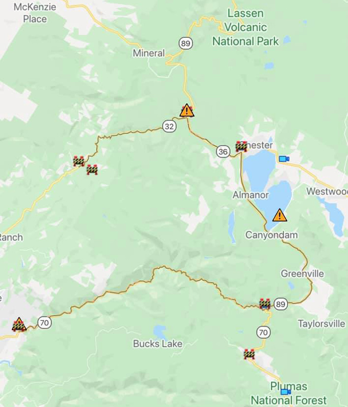
Update Per Plumas County Sheriff's Office: Due to increased fire activity on the Dixie Fire a Mandatory Evacuation Order has been issued for: Everything west of Hwy 89/36 Junction, west along the southside of Hwy 36 to the County line and south of Hwy 36 to Rock Lake and west to the County Line.
Those evacuating from the above area should go to the shelter at the Memorial Hall in Chester at 180 Gay Street.
A warning has been issued for: the north side of Hwy 36 from the Hwy 89/Hwy36, north along Stover Mtn Rd and west to the County Line.
MAP LINK: https://tinyurl.com/ydrapp24
If you need transportation out of the Mandatory Evacuation area you need to call: 530-283-6414
Update Per Plumas County Sheriff's Office: Due to increased fire activity on the Dixie Fire , Sheriff Johns has issued a Mandatory Evacuation Order for: Canyon Dam south to include Greenville and south of Greenville to include Crescent Mills. You should EVACUATE SOUTH TOWARDS QUINCY, immediately.
MAP LINK: https://tinyurl.com/ydrapp24
Hwy 89 is open to evacuate out of the area above; however, it is being closed to northbound traffic at Hwy 89 and Hwy 70 junction (Greenville Wye) and closed to southbound traffic at the Hwy 89/Hwy 147 junction.
There is a shelter at 59 Bell Lane in Quincy, the Springs of Hope Church.
*The shelter at 180 Gay Street in Chester is open again also.
If you need transportation out of the Mandatory Evacuation area you need to call: 530-283-6414
CAL FIRE/Butte County U.S. Forest Service-Plumas National Forest Lassen National Forest
Update: Special Thanks to Hawai’i Volcanoes National Park Engine Crew for Assisting on Dixie Fire
Update: Dixie Fire West Zone Operations Morning Briefing Video For Monday, August 2, 2021
Update: Dixie Fire East Zone Operations Morning Briefing Video for Monday, August 2, 2021
Update: Smoke/Air Quality Outlook for the Dixie Fire in the Eastern Sierra for Monday, August 2
August 2, 2021 - Dixie Fire in Butte County and Plumas County is 248,820 acres and 35% contained for Monday morning.
Update 7:40 A.M. CAL FIRE
'Click' here to view full PDF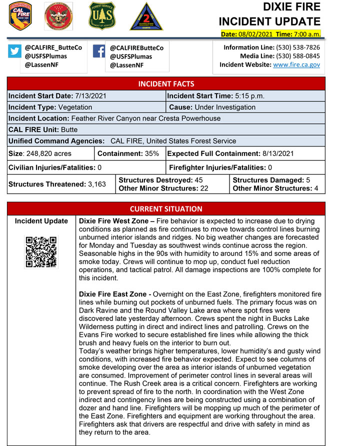
Basic Information
| Current as of | 8/2/2021, 6:42:59 AM |
| Incident Type | Wildfire |
| Cause | Under Investigation |
| Date of Origin | Tuesday July 13th, 2021 approx. 05:15 PM |
| Location | Feather River Canyon near Cresta Powerhouse |
| Incident Commander | CALFIRE Incident Management Team 1/California Interagency Incident Management Team 2 |
| Incident Description | Wildfire |
| Coordinates | 39.819 latitude, -121.419 longitude |
Current Situation
| Total Personnel | 5,463 |
| Size | 248,570 Acres |
| Percent of Perimeter Contained | 33% |
| Estimated Containment Date | Friday August 13th, 2021 approx. 12:00 AM |
| Fuels Involved |
Timber (Litter and Understory) Timber (Grass and Understory) Brush (2 feet) Fuel moistures are historically low, ERCs and BI are in the 97-99% |
| Significant Events |
Moderate Uphill Runs Creeping Backing Fire activity slowed during the evening hours, continuing to burn unburned islands and where no control lines are present. |
Outlook
| Planned Actions |
Construct direct and indirect line to secure fire perimeter. Construct contingency lines in both zones. Provide structure defense in communities at risk: Paxton, Greenville, Jonesville, Crescent Mills, Taylorsville, Canyondam, Butte Meadows, Bucks Lake, Meadows Valley, Rush Creek and Greater Alamnor area. Continue tactical patrol in the communities impacted by fire. |
| Projected Incident Activity |
Fire behavior expected to increase due to drying conditions. Fire continues to move towards controls lines burning unburned interior islands and ridges. Steep terrain, heavy fuel loading, and wind in alignment with canyons is making control difficult near div M and N break. On the East Zone expected area to grow is Division X within the Bucks Wilderness area. |
| Remarks |
California Interagency Incident management team 2 (CIIMT 2)has command of the East Zone. State DPA: 6551 Federal DPA:242019 |
Current Weather
| Weather Concerns |
EAST ZONE: Observed: Very warm conditions were noted this afternoon with humidity values falling down into the twenty to thirty percent range. A few sites were reporting relative humidity values in the teens. Afternoon satellite imagery showed atmospheric instability increasing as seen with the appearance of high based cumulus clouds and towering cumulus clouds. Forecast: Through the afternoon, additional towering cumulus clouds will develop. The potential that an isolated shower or storm could develop is low with a less than 20 percent chance. Any activity that develops could produce gusty outflow winds close to 25 mph. Otherwise, afternoon humidity between 15 and 20 percent should be expected, along with gusty general west winds near 20 mph. Across aligned drainages, gusts to near 25 mph cannot be ruled out. Afternoon temperatures in the upper 80s to near 100 degrees are forecast. Sunday Night, winds should subside, but may remain breezy and out of a more east or southerly direction along the ridgelines. Relative humidity of up to 45% is expected at mid-slope and higher elevations. RH recovery in the valleys and drainages should climb to near 55% or greater. Overnight temperatures in the lower drainage basins and valleys will likely fall below 55 degrees, while higher elevations will likely remain in the 60s and 70s. Patchy dense smoke will be possible, especially across elevated drainages and valleys. WEST ZONE: Smoke cleared from the west zone early today with mostly sunny skies. High temps into the 90s with humidity lowering into the upper teens. For tonight poor humidity recovery as evening southwest winds becoming light downcanyon overnight. No big weather changes forecast Monday and Tuesday as southwest winds continue across the region with seasonable highs in the 90s with humidity to around 15% A dry cold front on Wednesday will bring increasing southwest winds with unstable air aloft as hot and dry weather continues. Observed Weather Conditions: Mostly sunny with areas of smoke. Wind Speed / Max. Gust Southwest 8-12 mph gusts 16-20 mph Temp 88 to 98. Direction Southwest RH 17-24% Forecasted Weather for Next Operational Period Wind Speed / Max. Gust 14-18 mph Temp 63-73 Direction Northeast RH 30-45% |
Click here for: Dixie Fire in Butte and Plumas Counties Sunday, August 1, 2021 Updates
