


Update: California Dixie Fire Evening Incident Update Video for Saturday, August 7, 2021
Evening Update Per CAL FIRE: California #DixieFire is at 447,723 Acres, with 21% Containment for Saturday evening.

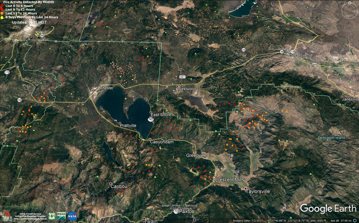
MODIS map of the Dixie Fire in Butte and Plumas Counties on Saturday at 4:30 A.M PST
Note: 1,200 Pixels Wide - Note: Older Yellow not shown
MODIS Active Fire Mapping Program Frequently Asked Questions
Update: Publics Assistance Needed in Locating Unaccounted for Individuals in the Dixie Fire Area
Update: Dixie Fire Containment Update Video for Saturday, August 7, 2021
Update: Dixie Fire West Zone Operations Morning Briefing Video For Saturday, August 7, 2021
Update: Dixie Fire East Zone Operations Morning Briefing Video for Saturday, August 7, 2021
Update: Smoke/Air Quality Outlook for the Dixie Fire in the Eastern Sierra for Saturday, August 7
August 7, 2021 - Dixie Fire in Butte County and Plumas County is 446,723 acres and 21% contained for Saturday morning.
Update 7:15 A.M. CAL FIRE, Revised at 8:35 A.M.
'Click' here to view full PDF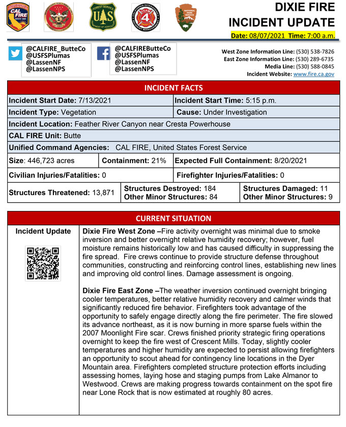
Basic Information
| Current as of | 8/7/2021, 6:39:27 AM |
| Incident Type | Wildfire |
| Cause | Under Investigation |
| Date of Origin | Tuesday July 13th, 2021 approx. 05:15 PM |
| Location | Feather River Canyon near Cresta Powerhouse and Lake Almanor. |
| Incident Commander | CALFIRE Incident Management Team 1 CA Interagency Incident Management Team 4 National Park Service |
| Incident Description | Wildfire |
| Coordinates | 39.819 latitude, -121.419 longitude |
Current Situation
| Total Personnel | 5,118 |
| Size | 446,723 Acres |
| Percent of Perimeter Contained | 21% |
| Estimated Containment Date | Friday August 20th, 2021 approx. 12:00 AM |
| Fuels Involved |
Timber (Litter and Understory) Timber (Grass and Understory) Brush (2 feet) Fuel moistures are historically low, ERCs and BI are in the 97-99% |
| Significant Events |
Observed Fire Behavior or Significant Events for the Time Period Reported (describe fire behavior using accepted terminology. For non-fire incidents, describe significant events related to the materials or other causal agents): Minimal Single Tree Torching Flanking Backing Narrative: Fire activity overnight was minimal due to smoke inversion and better overnight RH recovery. |
Outlook
| Planned Actions |
Construct direct and indirect line to secure fire perimeter. Structure Prep along the East Shore. Unable to staff contingency lines due to all resources committed to Fire Front Following, providing structure defense in surrounding impacted communities. Provide structure defense in communities at risk: Chester, Hwy 36 corridor, Hwy 89 Corridor, Paxton, Greenville, Jonesville, Crescent Mills, Taylorsville, Prattville, Canyondam, Butte Meadows, Bucks Lake, Meadows Valley, Rush Creek, Warner Valley, Pecks Valley, Williams Valley, Hunt Canyon, and Greater Almanor area. Continue tactical patrol in the communities impacted by fire. |
| Projected Incident Activity |
12 hours: Moderate conditions. Expect the fire to remain active through the morning hours. The valleys will see RH recovery up to 55%. There may be potential for crews to make headway on building containment lines. Smoke shading from fires in the region may reduce fire intensity. Fire has entered Lassen National Park and is expected to continue burning north through the park. Spot Fire 3.8 miles east of main body of fire on East Zone at Lone Rock. 24 hours: Slightly warmer today. Expect a moderate risk burn environment due to moderate temps, low RH and extremely receptive fuels. The atmosphere will be somewhat unstable with a Haines of 4. Forecasted winds will be SW16 mph with 5% cloud cover. Fire behavior will consist of wind driven surface file, group torching and crown fire where alignment exist. Moderate overnight recoveries may provide opportunity for line construction and/or firing operations. Fire has entered Lassen National Park and is expected to continue burning north through the park. 48 hours: Temperatures will be in the high 80's today and will remain in that profile over the next few operational periods. 5% cloud cover forecasted during the burning period. Fire behavior will remain active to include wind driven surface fire, group torching, crown runs with alignment and spotting. Moderate overnight recoveries may provide opportunity for line construction and/or firing operations. SW winds will test open line on all branches. Local thresholds will be exceeded. Expect comparable fire behavior as the previous day. Fire has entered Lassen National Park and is expected to continue burning north through the park. 72 hours: Similar profile as the previous operational period. Expect comparable fire behavior as the previous operational period. Forecasted hot and dry weather through the end of the week. Anticipated after 72 hours: Expect similar burning conditions. Temperatures will remain in the high 80s and low 90s. |
| Remarks |
California Interagency Incident Management Team 4 (CIIMT 4) is in command of the East Zone. State DPA: 59,391 Federal DPA: 366,991 NPS DPA: 8,430 |
Current Weather
| Weather Concerns |
EAST ZONE: Overnight, light and variable winds prevailed. Relative humidity recovery was better than previous night. In fact, the range of humidity recovery was 35-65%. For today, another smoky day is anticipated across the incident. The smoke will once again moderate the weather conditions across the fire. Light and variable winds in the morning will become southwesterly with gusts to around 15 MPH in the afternoon. Relative humidity will drop into the teens while afternoon temperatures climb into the 70s to lower 80s. WEST ZONE: Smoke stayed over the fire today providing stable weather conditions. The smoke was thick enough to keep temperatures cooler and humidity higher than previous days. In addition, the stable inversion layer prevented any strong winds from mixing to the surface and through the crowns across the West Zone. Thick smoke will settle over the fire. |
Click here for: Dixie Fire in Butte and Plumas Counties Friday, August 6, 2021 Updates
