


NEW Update: Lassen County Sheriff's Office Issues New Mandatory Evacuation Orders & Warnings for the Dixie Fire
Update: Dixie Fire West Zone Virtual Community Meeting Evening Update Video for Monday, August 16, 2021
Important Update: CAL FIRE Announce Plans to Amend the Current Management Zones of the Dixie Fire Beginning Tuesday, August 17, 2021
Update: Dixie Fire East Zone Evening Operations Update Video for Monday, August 16, 2021
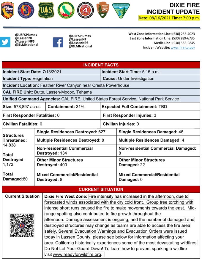
Evening Update Per CAL FIRE: California Dixie Fire is at 578,897 Acres, with 31% Containment, and 6,579 personnel assigned for Monday evening.
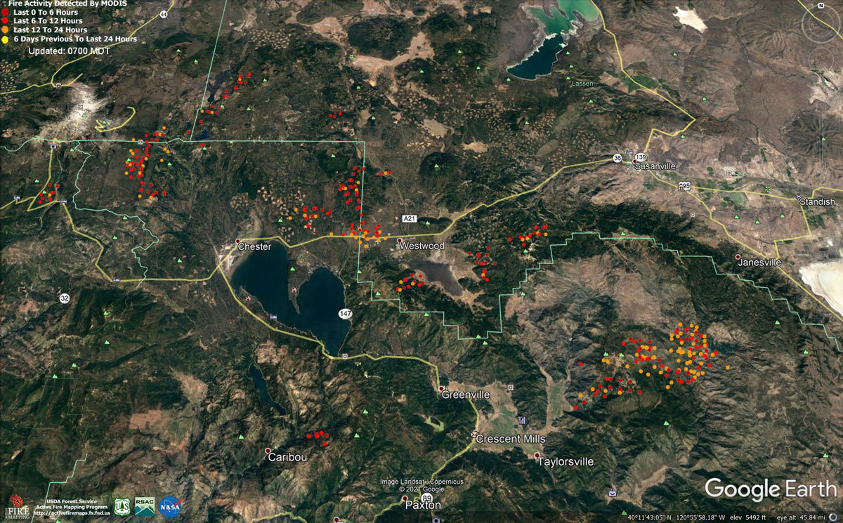
MODIS map of the Dixie Fire on Monday at 6:00 A.M PST
Note: 1,200 Pixels Wide - Note: Older Yellow not shown
MODIS Active Fire Mapping Program Frequently Asked Questions
Update: CAL FIRE Statewide Fire Update Video for Monday, August 16, 2021
NEW Update: Lassen County Sheriff's Office Issues New Mandatory Evacuation Orders & Warnings for the Dixie Fire
Update: Susanville Police Department Issue a Public Information Notice to Residents for the Dixie Fire
Update: Dixie Fire West Zone Operations Morning Briefing Video for Monday, August 16, 2021
Update: Dixie Fire East Zone Operations Morning Briefing Video for Monday, August 16, 2021
Update: Smoke/Air Quality Outlook for the Dixie Fire in the Eastern Sierra for Monday, August 16
Update: Dixie Fire Morning Briefing Video for Monday, August 16, 2021
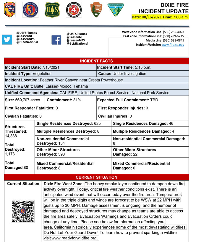
August 16, 2021 - Dixie Fire is 569,707 acres and 31% contained for Monday morning.
Update 7:20 A.M. CAL FIRE
Basic Information
| Current as of | 8/16/2021, 6:45:42 AM |
| Incident Type | Wildfire |
| Cause | Under Investigation |
| Date of Origin | Tuesday July 13th, 2021 approx. 05:15 PM |
| Location | Feather River Canyon near Cresta Powerhouse and Lake Almanor. |
| Incident Commander | CALFIRE Incident Management Team 3 CA Interagency Incident Management Team 4 NPS/BLM |
| Incident Description | Wildfire |
| Coordinates | 39.819 latitude, -121.419 longitude |
Current Situation
| Total Personnel | 6,546 |
| Size | 569,707 Acres |
| Percent of Perimeter Contained | 31% |
| Estimated Containment Date | Monday August 30th, 2021 approx. 12:00 AM |
| Fuels Involved |
Timber (Litter and Understory) Timber (Grass and Understory) Brush (2 feet) Fuel moistures are historically low, ERCs and BI are in the 97-99%. Northern California remains under a Fuels and Fire Behavior Advisory. |
| Significant Events |
Active: Uphill Runs Group Torching Short-range Spotting Narrative: Smoke layer continued to dampen down fire activity for the night, but did not prevent the heavy dead and down fuels from continuing to burn. Lower humidity recovery allowed the burn window to stay open longer than previous shifts. Light winds remained over the fire for the night, but did not create any challenges to control lines. |
Outlook
| Planned Actions |
Construct direct and indirect line to secure fire perimeter. Direct line construction in the Westwood area will require a heavy resource presence. Provide for service calls within communities impacted by the fire: Chester, Hwy 36 corridor, Hwy 89 Corridor, Paxton, Greenville, Jonesville, Crescent Mills, Taylorsville, Prattville, Canyondam, Butte Meadows, Bucks Lake, Meadows Valley, Rush Creek, Warner Valley, Pecks Valley, Williams Valley, Hunt Canyon, Susanville, and the Greater Almanor area. Structure defense will continue in communities on the north end of Lake Almanor and in Warner Valley. Continue structure defense near Willow Dip at the southern end of Lassen Nat'l Park and within the Park itself. Protect threatened areas of Janesville, Indicator Peak and Loan Peak. Heavy mop and patrol of communities impacted by the fire front. "Make Safe" for repopulation. Crews in the Cradle Valley area are currently performing structure preparations in anticipation of further action in area. Structure protection continues in the Wilcox Valley region. Resources will be working from Dyer Mountain east to Mountain Meadow Reservoir utilizing direct line to complete action in that area. Holding actions from previous firing operations will require a significant resource presence for the next several operational periods. |
| Projected Incident Activity |
12 hours: Moderate overnight conditions. Potential to have longer burn period due to excessive heat during the day operational period. Expect the fire activity to decrease through the late evening early morning hours. Overnight recovery will be up to 65%. Potential for crews to make progress on building containment lines and firing operations with increased RH. 24 hours: Temperatures will be in the triple digits today. The atmosphere will be unstable with a Haines of 5. Forecasted winds will be WSW 22 mph with 15% cloud cover. Fire behavior will consist of wind driven surface fire, isolated torching and spotting. Moderate overnight recoveries may provide opportunity for line construction and firing operations. Local thresholds will be exceeded. Expect comparable fire behavior as the previous operational period. The fire will most likely spread to the North, Northeast, East due to sustained SW winds. In anticipation of an upcoming wind event (8/16 1400-300hrs), Wildfire Analyst (WFA) and FSPRO were utilized to assess the potential impacts from fire spread. **The WFA Probabilistic model was used and assumes no suppression actions.** In the West Zone - Diamond Branch, models project an 80% chance of the fire reaching Willard Drainage and a 5-20% chance the fire will impact the town of Susanville. Also within the Diamond Branch (East Zone - Branch 22), models project an 80% chance of the fire reaching Wildcat Ridge and a 10-20% chance of impacting the town of Janesville. Success of firing operations (8/14) near Antelope Lake has the potential to reduce fire spread towards Janesville. In the West Zone - Branch 16, models project a 10% chance the fire will impact Highway 44. 48 hours: Moderate Risk burn environment. Temperatures will be in the high 90's today and will be similar over the next few operational periods. Winds will be W 20 mph. 10% cloud cover forecasted during the burning period. Fire behavior would include wind driven surface fire, group torching, crown runs with alignment and spotting. Moderate overnight recoveries may provide opportunity for line construction and firing operations. Local thresholds will be exceeded. Expect an increase in fire activity with clear air. 72 hours: Temperatures will be in the mid 90's over the next few shifts. Expect comparable fire behavior as the previous operational period. Forecasted hot and dry weather through the end of the week. Anticipated after 72 hours: Expect similar burning conditions. Temperatures will remain in the high 90's throughout the week. |
| Remarks |
California Interagency Incident Management Team 4 (CIIMT4)is in command of the East Zone. East Zone Unified Command Agencies: Plumas National Forest CIIMT1 will in-brief with CIIMT4 today at 1400. CAL FIRE IMT3 is in command of the West Zone. West Zone Unified Command Agencies: Bureau of Land Management, CAL FIRE, Lassen National Forest, National Park Service Acreage by DPA: State- 91,718 Federal- 444,308 Nat'l Park-18,790 Continuation of Box 31: In indoor temporary shelters - 182 In outdoor temporary shelters - 226 EAST ZONE PERSONNEL: 846 FIRELINE AND 280 SUPPORT- TOTAL: 1,126 |
Current Weather
| Weather Concerns |
EAST ZONE: Smoke heavily moderated the weather conditions so far today. Temperatures this afternoon climbed into the mid to upper 90's and minimum relative humidity values dipped into the teens and low teens. Variable drainage winds shifted up canyon in the afternoon with gusts around 10-15 MPH. A slight chance of thunderstorms remains through the evening. Tonight: mostly clear but anticipate smoky conditions to return with subsequent impacts to visibility. Overnight humidity recoveries will be poor to moderate. Southwest winds will give way to weak drainage winds overnight. Expect temperatures in the thermal belt to remain near and above 70 degrees. WEST ZONE: High pressure sat over the incident but a change in the weather pattern is expected as this high begins to break down. The high pressure will be replaced by a trough of low pressure that will swing through Monday and Tuesday. This will result in a dry,stable southwest flow on Monday before the upper level flow becomes more northwest on Tuesday. Breezy conditions are expected both days which will help with smoke dispersion but likely lead to control issues. Smoke remained over the incident on Sunday and while it remained quite heavy in the valleys, some thinning was noted in the higher elevations. Temperatures were very warm with highs in the upper 80's to upper 90's. It was also very dry with humidity dropping down to 12 to 20%. Winds continued to be mainly light and terrain driven. A stray thunderstorms will be possible through mid-evening with temperatures still in the mid-70's to lower 80's in the late evening. Humidity has only recovered into the upper teens to mid-20's and winds remaining light away from thunderstorms. |
Click here for: California Dixie Fire Sunday, August 15, 2021 Updates
