


LATE Update: Dixie Fire Evacuation Orders Have Been Issued Effective Immediately for the Town of Mineral in Tehama County
Update: Dixie Fire East Zone Evening Operations Update Video for Tuesday, August 17, 2021
Update: Dixie Fire East Zone Virtual Community Meeting Evening Update Video for Tuesday, August 17, 2021
Update: New Evacuation Information for 7:00 P.M.
Lassen County Sheriff's Office Issues New Mandatory Evacuation Orders & Warnings for the Dixie Fire on Tuesday, August 17, 2021
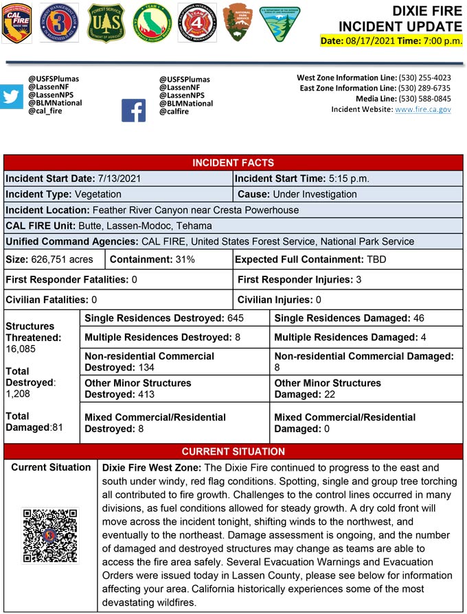
Evening Update Per CAL FIRE: California Dixie Fire is at 626,751 Acres, with 31% Containment, and 6,041 personnel assigned for Tuesday evening.
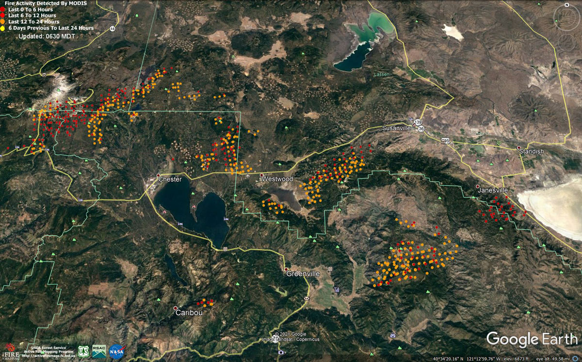
MODIS map of the Dixie Fire on Tuesday at 5:30 A.M PST
Note: 1,200 Pixels Wide - Note: Older Yellow not shown
MODIS Active Fire Mapping Program Frequently Asked Questions
Update: Dixie Fire East Zone Virtual Community Meeting Set for 7:30 P.M. Tonight, August 17, 2021
Update: Traffic and Travel Updates Have Been Issued for Highways 395 & 44 in the Dixie Fire Area
Update: BLM Closes Bizz Johnson Trail, Public Lands, Roads Due to Dixie Fire
Update: Dixie Fire East Zone Operations Morning Briefing Video for Tuesday, August 17, 2021
Update: Smoke/Air Quality Outlook for the Dixie Fire in the Eastern Sierra for Tuesday, August 17
Update: Dixie Fire Morning Briefing Video for Tuesday, August 17, 2021
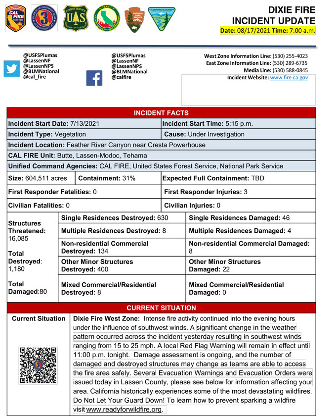
August 17, 2021 - Dixie Fire is 604,511 acres and 31% contained for Tuesday morning.
Update 7:45 A.M. CAL FIRE
Basic Information
| Current as of | 8/17/2021, 7:20:58 AM |
| Incident Type | Wildfire |
| Cause | Under Investigation |
| Date of Origin | Tuesday July 13th, 2021 approx. 05:15 PM |
| Location | Feather River Canyon near Cresta Powerhouse and Lake Almanor. |
| Incident Commander | CALFIRE Incident Management Team 3 CA Interagency Incident Management Team 4 NPS/BLM |
| Incident Description | Wildfire |
| Coordinates | 39.819 latitude, -121.419 longitude |
Current Situation
| Total Personnel | 6,579 |
| Size | 578,897 Acres |
| Percent of Perimeter Contained | 31% |
| Estimated Containment Date | Monday August 30th, 2021 approx. 12:00 AM |
| Fuels Involved |
Timber (Litter and Understory) Timber (Grass and Understory) Brush (2 feet) Narrative: Fuel moistures are historically low, ERCs and BI are in the 97-99%. Northern California remains under a Fuels and Fire Behavior Advisory. |
| Significant Events |
Active: Uphill Runs Group Torching Short-range Spotting Narrative: Smoke early over the fire kept activity moderated to start the day. Winds associated with the dry cold front arrived as forecasted and quickly increased fire intensity in the afternoon. Group tree torching with intense short runs caused the fire to make movements east. Mid range spotting also contributed to fire growth throughout the afternoon. Red Flag Warning in effect from 1500 today through 2300 Tuesday, for strong SW winds. Expect active fire behavior in the East Zone today. Temperatures will be in the high 90's over the next few operational periods. Haines of 5 will introduce unstable air over the incident. Potential for Plume dominated fire behavior due to instability. All Fuels remain available. Fuel moistures remain critically low for both live and dead. The Energy Release Component is just below the 97th percentile and climbing. All thresholds for the Plumas Central have been exceeded. |
Outlook
| Planned Actions |
Construct direct and indirect line to secure fire perimeter. Direct line construction in the Westwood area will require a heavy resource presence. Provide for service calls within communities impacted by the fire: Chester, Hwy 36 corridor, Hwy 89 Corridor, Paxton, Greenville, Jonesville, Crescent Mills, Taylorsville, Prattville, Canyondam, Butte Meadows, Bucks Lake, Meadows Valley, Rush Creek, Warner Valley, Pecks Valley, Williams Valley, Hunt Canyon, Susanville, and the Greater Almanor area. Structure defense will continue in communities on the north end of Lake Almanor and in Warner Valley. Continue structure defense near Willow Dip at the southern end of Lassen Nat'l Park and within the Park itself. Protect threatened areas of Janesville, Indicator Peak and Loan Peak. Heavy mop and patrol of communities impacted by the fire front. "Make Safe" for repopulation. Crews in the Cradle Valley area are currently performing structure preparations in anticipation of further action in area. Structure protection continues in the Wilcox Valley region. Resources will be working from Dyer Mountain east to Mountain Meadow Reservoir utilizing direct line to complete action in that area. Holding actions from previous firing operations and point protection of communities and critical infrastructure will require a significant resource presence for the next several operational periods. Continued mop up of and patrol of 1,000-hr fuels will require a significant amount of resources due to the volume of fuels and the steep and rugged terrain. In anticipation of the upcoming wind event (8/16 1400-2300hrs), a "flex shift" (noon-noon) will be initiated to ensure complete coverage during the event. |
| Projected Incident Activity |
12 hours: In anticipation of theupcoming wind event (8/16 1400-300hrs), Wildfire Analyst (WFA) and FSPRO were utilized to assess the potential impacts from fire spread. **The WFA Probabilistic model was used and assumes no suppression actions. ** In the West Zone - Diamond Branch, models project an 80% chance of the fire reaching Willard Drainage and a 5-20% chance the fire will impact the town of Susanville. Also within the Diamond Branch (East Zone - Branch 22), models project an 80% chance of the fire reaching Wildcat Ridge and a 10-20% chance of impacting the town of Janesville. Success of firing operation (8/14) near Antelope Lake has the potential to reduce fire spread towards Janesville. In the West Zone - Branch 16, models project a 10% chance the fire will impact Highway 44. 24 hours: The Red Flag Warning forecasted to expire at 2300 Tuesday. Temperatures will be in the 90's. The atmosphere will be unstable with a Haines of 5. Forecasted winds will be W 26 mph with 10% cloud cover. Fire behavior will consist of wind driven surface fire, isolated torching and spotting. Moderate overnight recoveries may provide opportunity for line construction and firing operations. Local thresholds will be exceeded. Expect comparable fire behavior as the previous operational period. The fire will most likely spread to the North, Northeast, East due to sustained SW winds. 48 hours: Moderate Risk burn environment. A dry cold front is forecasted to move through the region. Temperatures will be in the mid 80's today and tomorrow. Winds will be NE 16 mph.10% cloud cover forecasted during the burning period. Fire behavior would include surface fire potential for group torching, crown runs with alignment and spotting. Moderate overnight recoveries may provide opportunity for line construction and firing operations. Local thresholds will be exceeded. Expect an increase in fire activity with clear air. 72hours: Temperatures will be in the mid 90's over the next few shifts. NW winds forecasted due to the cold front passage. Expect comparable fire behavior as the previous operational period. Forecasted hot and dry weather through the end of the week. Anticipated after 72 hours: Expect similar burning conditions. Temperatures will remain in the high 90s throughout the week. |
| Remarks |
Continuation of Box 4: California Interagency Incident Management Team 4(CIIMT 4)is in command of the East Zone. East Zone Unified Command Agencies: Plumas National Forest and Lassen National Forest CIIMT1 has arrived at the East Zone ICP and has in-briefed with CIIMT4. CIIMT1 will assume command of the East Zone at 0700 on 8/17. CAL FIRE IMT3 is in command of the West Zone. West Zone Unified Command Agencies: Bureau of Land Management, CAL FIRE, Lassen National Forest, National Park Service Continuation of Box 7: 450 acres of the total acres reported is the Morgan Fire. 0% containment. Continuation of Box 25: The fire area is in portions of Butte, Lassen, Plumas, Shasta, and Tehama counties. Active fronts are in the Greater Lake Almanor area, Lassen NF, and Lassen NP, as well as on several private timber ownerships. Continuation of Box 31(J): Civilians in indoor temporary shelters - 88 Civilians in outdoor temporary shelters - 260 Continuation of Box 32(E): East Zone - 1 responder injury West Zone - 2 responder injuries Continuationof Box 38: Additional threatened values at risk include: Bizz Johnson National Recreation Trail Continuation of Box 48: Resource count reduced due to reconciliation of assigned resources between East and West Zones. |
Current Weather
| Weather Concerns |
EAST ZONE: Weather was active today with the approach of the incoming storm system. Temperatures this afternoon climbed into the mid to upper 90's and minimum relative humidity values dipped into the teens and low teens. Variable drainage winds shifted southwest in the afternoon with gusts around 25-30 MPH. Due to the gusty winds, hot temperatures, instability, and low RH a local Red Flag Warning was put into effect from 1500hrs today through 2300hrs Tuesday. Tonight: mostly clear but locally breezy winds will persist, tapering off around 2200hrs and becoming downslope/down valley. Overnight humidity recoveries will be poor to moderate. WEST ZONE: A significant change in the weather pattern occurred across the incident on Monday. The dominant upper level ridge of high pressure has been displaced to the southeast by an upper level trough of low pressure. This trough of low pressure brought southwest winds to the incident with 15 to 25 mph gusts common. This resulted in widespread plume dominated fires. It remained very warm and dry across the incident. A cold front will move across on Tuesday which will increase winds even more with gusts near 40 mph possible and control problems are expected. A local red flag warning remains in effect through Tuesday. The smoke did thin out across most of the incident by early afternoon and wind speeds picked up accordingly. High temperatures climbed into the mid-80s to mid-90s with humidity in the mid-teens. Southwest winds of 15 to 25 mph occurred in the exposed areas with light winds in the valley locations. Gusty southwest winds will slowly diminish this evening but it will remain warm and dry. Temperatures will still be in the mid-70's to lower 80's in the late evening. |
Click here for: California Dixie Fire Monday, August 16, 2021 Updates
