


Update: Dixie Fire East Zone Evening Operations Update Video for Thursday, August 19, 2021
Update: Dixie Fire East Zone Virtual Community Meeting Evening Update Video for Thursday, August 19, 2021
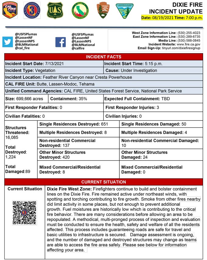
Evening Update Per CAL FIRE: California Dixie Fire is at 699,666 Acres, with 35% Containment, and 5,696 personnel assigned for Thursday evening.
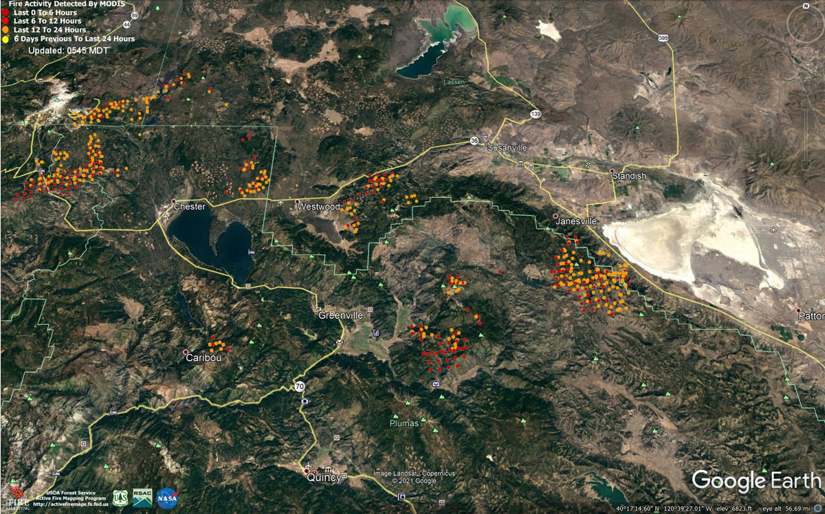
MODIS map of the Dixie Fire on Thursday at 4:45 A.M PST
Note: 1,200 Pixels Wide - Note: Older Yellow not shown
MODIS Active Fire Mapping Program Frequently Asked Questions
Update: Dixie Fire East Zone Virtual Community Meeting Tonight (Thursday, August 19) at 7:30 P.M.
Update: Lassen County Sheriff Dixie Fire Road Closure Update for August 19, 2021, at 12:00 P.M.
Update: Dixie Fire East Zone Operations Morning Briefing Video for Thursday, August 19, 2021
Update: Plumas County Sheriff's Office Reports Rush Creek Residents Can Return Home
Update: Dixie Fire West Zone Operations Morning Briefing Video for Thursday, August 19, 2021
Update: Smoke/Air Quality Outlook for the Dixie Fire in the Eastern Sierra for Thursday, August 19
Update: Dixie Fire Morning Briefing Video for Thursday, August 19, 2021
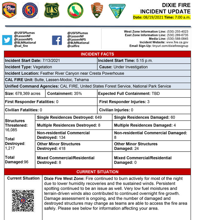
August 19, 2021 - Dixie Fire is 678,369 acres and 35% contained for Thursday morning.
Update 7:20 A.M. CAL FIRE
Basic Information
| Current as of | 8/19/2021, 6:20:10 AM |
| Incident Type | Wildfire |
| Cause | Under Investigation |
| Date of Origin | Tuesday July 13th, 2021 approx. 05:15 PM |
| Location | Feather River Canyon near Cresta Powerhouse and Lake Almanor. |
| Incident Commander | Billy See, CALFIRE IMT 3 Jerry McGowan, CIIMT 1 Jay Lusher, NPS/BLM |
| Incident Description | Wildfire |
| Coordinates | 39.819 latitude, -121.419 longitude |
Current Situation
| Total Personnel | 5,982 |
| Size | 662,647 Acres |
| Percent of Perimeter Contained | 35% |
| Estimated Containment Date | Thursday September 30th, 2021 approx. 12:00 AM |
| Fuels Involved |
Fuel moistures are historically low, ERCs and BI are in the 97-99%. Northern California remains under a Fuels and Fire Behavior Advisory |
| Significant Events |
Active: Wind Driven Runs Group Torching Short-range Spotting Narrative: Fire increased in activity due to clearing smoke and northeast winds. With the change in wind direction, large column and pyrocumulus development occurred throughout the afternoon. Group tree torching and mid range spotting contributed to fire growth in the timbered areas. Fire in steep topography was pushed by channeling winds, increasing spread rates. Northeast winds occurred over the fire today. Post-frontal passage winds drove increased activity with torching, individual and group tree torching, and passive/active crown runs. Haines of 4 after the breakdown of ridge will introduce clear air over the next couple days to the incident. Potential still exists for plume dominated fire behavior with alignment of fuels, topography and extremely dry fuels. All fuels remain available. Fuel moistures remain critically low for both live and dead. The Energy Release Component is above the 97th percentile and climbing. Dead fuel moisture percent for 100hr and 1000hr size class fuels maintain a near record minimum fuel moisture in the lowest percentiles, 5 and 6 percent respectively. Local thresholds for fire danger on Plumas NF (East Zone) Pocket Card continue to be exceeded daily. |
Outlook
| Planned Actions |
Construct direct and indirect line to secure fire perimeter. Direct line construction in the Westwood area will require a heavy resource presence. Provide for service calls within communities impacted by the fire: Chester, Hwy 36 corridor, Hwy 89 Corridor, Paxton, Greenville, Jonesville, Crescent Mills, Taylorsville, Prattville, Canyon dam, Butte Meadows, Bucks Lake, Meadows Valley, Rush Creek, Warner Valley, Pecks Valley, Williams Valley, Hunt Canyon, Susanville, and the Greater Almanor area. Structure defense will continue in communities on the north end of Lake Almanor and in Warner Valley. Continue structure defense near Willow Dip at the southern end of Lassen Nat'l Park and within the Park itself. Protect threatened areas of Janesville, Indicator Peak and Loan Peak. Heavy mop and patrol of communities impacted by the fire front. "Make Safe" for repopulation. Crews in the Cradle Valley area are currently performing structure preparations in anticipation of further action in area. Structure protection continues in the Wilcox Valley region. Resources will be working from Dyer Mountain east to Mountain Meadow Reservoir utilizing direct line to complete action in that area. Holding actions from previous firing operations and point protection of communities and critical infrastructure will require a significant resource presence for the next several operational periods. Continued mop up of and patrol of 1,000-hr fuels will require a significant amount of resources due to the volume of fuels and the steep and rugged terrain. |
| Projected Incident Activity |
12 hours: Moderate overnight conditions. Potential to have longer burn period due to excessive heat during the day operational period. Overnight recovery will be up to 35-70%. Potential for crews to make progress on building containment lines and firing operations with increased RH, cooler nighttime temperatures, and decreased nighttime wind speeds. 24 hours: Temperatures will be in the mid to upper 70's. Forecasted winds from the NE-N today. The atmosphere will be improving in stability with a Haines of 3. Fire behavior will consist of wind driven surface fire, roll out, isolated torching and spotting. Moderate overnight recoveries may provide opportunity for line construction and firing operations. Expect comparable fire behavior as the previous operational period. The fire will most likely spread to the South and be topography/slope/fuel continuity driven spread. 48 hours: Temperatures will be in the upper 80's to low 90's today and will be similar over the next few operational periods. Fire behavior would include wind driven surface fire, group torching, crown runs with alignment and spotting. Moderate overnight recoveries may provide opportunity for line construction and firing operations. Local thresholds will be exceeded. Expect an increase in fire activity with clear air. 72 hours: Temperatures will be in the mid 80's over the next few shifts. Expect comparable fire behavior as the previous operational period. Forecasted hot and dry weather through the end of the week. Anticipated after 72 hours: Expect similar burning conditions. Temperatures will remain in the high 80's throughout the week. |
| Remarks |
Continuation of Box 4: California Interagency Incident Management Team 1(CIIMT 1)is in command of the East Zone. East Zone Unified Command Agencies: Plumas National Forest and Lassen National Forest CAL FIRE IMT3 is in command of the West Zone. West Zone Unified Command Agencies: Bureau of Land Management, CAL FIRE, Lassen National Forest, National Park Service Continuation of Box 7: 450 acres of the total acres reported is the Morgan Fire. 0% containment. Continuation of Box 25: The fire area is in portions of Butte, Lassen, Plumas, Shasta, and Tehama counties. Active fronts are in the Greater Lake Almanor area, Lassen NF, and Lassen NP, as well as on several private timber ownerships. Continuation of Box 31(J): Civilians in indoor temporary shelters - 94 Civilians in outdoor temporary shelters - 260 Continuation of Box 32(E): East Zone - 1 responder injury West Zone - 2 responder injuries Continuation of Box 38: Additional threatened values at risk include: Bizz Johnson National Recreation Trail Continuation of Box 48: Resource count reduced due to reconciliation of assigned resources between East and West Zones. |
Current Weather
| Weather Concerns |
EAST ZONE: A cold front passed by Tuesday night leaving cooler air in place over the region. Temperatures were about 10 degrees cooler than Tuesday, but RH's remained fairly low due to the dry air behind the front. Winds turned to the northeast and gusted over 20 mph at ridge top through the afternoon. Tonight: Winds will continue from the northeast until midnight. Then mainly terrain driven winds will take over though the night. Thermal belt development will be weak as low pressure continues to exit the area. West Zone: A dry cold front moved across most of the incident Tuesday evening with an abrupt and noticeable wind shift behind it. The front cleared the entire incident by sunrise Wednesday bringing improved ventilation and considerably less smoke. It was also noticeably cooler across the incident on Wednesday as gusty north to northeast winds prevailed. Those northeast winds will continue tonight and Thursday as an anomalously deep upper level trough moves into the Great Basin. The next upper level trough will approach the incident late Friday and into Saturday. A red flag warning continues for the majority of the incident for mainly the higher elevations and wind prone areas through late Thursday morning. Heavy smoke was evident where active burning was occurring. Otherwise, skies were generally clear with some light smoke and haze. High only climbed into the upper 60's to mid-70's with minimum RH's dropping into the mid to upper teens. Winds were north to northeast at 10 to 20 mph with gusts as high as 35 mph along the ridge tops and in drainages where the wind aligned with topography. Gusty northeast winds will continue this evening around 10 to 20 mph. Temperatures will be dropping into the mid upper 50's to lower 60's by late evening. Humidity will only recover into the lower to mid-20's. |
Click here for: California Dixie Fire Wednesday, August 18, 2021 Updates
