


Note: Click here for Saturday's Updates
California Dixie Fire Saturday, August 28, 2021 Updates
Update: Dixie Fire East Zone Evening Operations Update Video for Friday, August 27, 2021
Update: Dixie Fire East Zone Virtual Community Meeting Evening Update Video for Friday, August 27, 2021
Evening Update Per CAL FIRE: California Dixie Fire is at 752,920 Acres, with 47% Containment, and 4,706 personnel assigned for Friday evening.
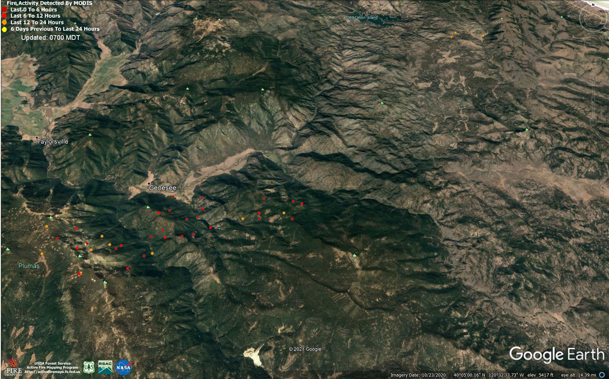
MODIS map of the Dixie Fire on Friday at 6:00 A.M PST
Note: 1,200 Pixels Wide - Note: Older Yellow not shown
MODIS Active Fire Mapping Program Frequently Asked Questions
Update: Dixie Fire West Zone Operations Morning Briefing Video for Friday, August 27, 2021
Update: Dixie Fire Operational Updates from Lassen National Forest for Friday, August 27, 2021
Update: Dixie Fire Evacuation Information & Updates for Friday, August 27, 2021
Update: Dixie Fire East Zone Virtual Community Meeting Set for 7:30 P.M. Tonight, August 27, 2021
Update: Dixie Fire East Zone Operations Morning Briefing Video for Friday, August 27, 2021
Update: Dixie Fire East Zone Update for Friday Morning, August 27, 2021
Update: Dixie Fire East Zone Operational Update for Friday Morning
Update: Smoke/Air Quality Outlook for the Dixie Fire in the Eastern Sierra for Friday, August 27, 2021
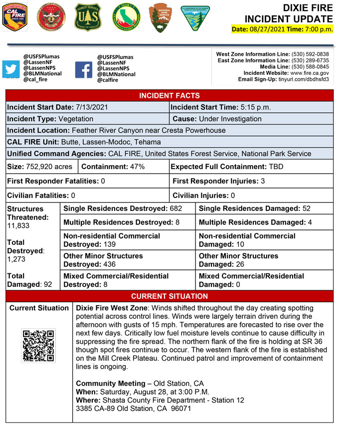
August 27, 2021 - Dixie Fire is 750,672 acres and 46% contained for Friday morning.Update CAL FIRE
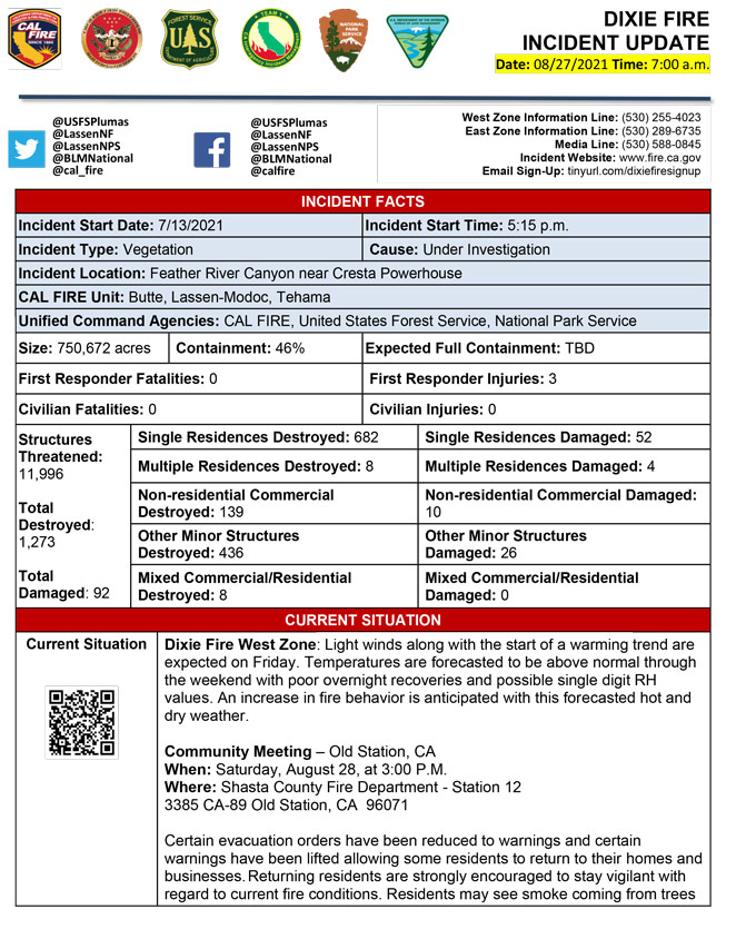
Basic Information
| Current as of | 8/27/2021, 7:00:02 AM |
| Incident Type | Wildfire |
| Cause | Under Investigation |
| Date of Origin | Tuesday July 13th, 2021 approx. 05:15 PM |
| Location | Feather River Canyon near Cresta Powerhouse and Lake Almanor. |
| Incident Commander | Billy See, CALFIRE IMT 3 Jerry McGowan, CIIMT 1 Jay Lusher, NPS/BLM |
| Incident Description | Wildfire |
| Coordinates | 39.819 latitude, -121.419 longitude |
Current Situation
| Total Personnel | 4,753 |
| Size | 750,672 Acres |
| Percent of Perimeter Contained | 46% |
| Estimated Containment Date | Thursday September 30th, 2021 approx. 12:00 AM |
| Fuels Involved |
Fuel moistures are historically low, ERCs and BI are in the 97-99%. Northern California remains under a Fuels and Fire Behavior Advisory. |
| Significant Events |
Active: Wind Drive Runs Group Torching Short-range Spotting Narrative: Shifting winds continued through the night, causing control issues. Lower humidity allowed active burning for most of the night. Short range spotting and isolated torching continued along with active ground fire in the northern portions. Smoldering and ground fire on the remaining portions of the fire were observed. |
Outlook
| Planned Actions |
Construct direct and indirect line to secure fire perimeter. Direct line construction in the Westwood area will require a heavy resource presence. Provide for service calls within communities impacted by the fire: Chester, Hwy 36 corridor, Hwy 89 Corridor, Hwy 395 corridor, Paxton, Greenville, Jonesville, Crescent Mills, Taylorsville, Prattville, Canyondam, Butte Meadows, Bucks Lake, Meadows Valley, Rush Creek, Warner Valley, Pecks Valley, Williams Valley, Hunt Canyon, Susanville, Janesville, and the Greater Almanor area. Structure defense and heavy mop up continues in Warner Valley, Cradle Valley, and Wilcox Valley. Protect threatened areas of Janesville, Indicator Peak and Loan Peak. Heavy mop and patrol of communities impacted by the fire front. "Make Safe" for repopulation. Resources will be working from Dyer Mountain east to Mountain Meadow Reservoir utilizing direct line to complete action in that area. Continued mop up of and patrol of 1,000-hr fuels will require a significant amount of resources due to the volume of fuels and the steep and rugged terrain. Priority areas include Genesee Valley, Taylorsville, and the Janesville/Milford area, as well as continued holding of the Hwy 36 corridor and the Mill creek drainage. Fire is well established in the Mill Creek Plateau. Continue patrol of constructed line and prevent the fire entering Mill Creek drainage. Resources in the Genesee Valley area continue protect the community of Taylorsville and limit spread from spot fires and active flanks. Resources continue to hold the Hwy 36 corridor and monitor for spots across the highway. Continued holding actions and point protection of communities and critical infrastructure will require a significant resource presence for the next several operational periods. Tactics that utilize fewer resources are being implemented in the Lassen Sector. Firing plans are being developed for West Zone - Div K. |
| Projected Incident Activity |
12 hours: Light northeast winds expected in the wake of the exiting low pressure trough. Overnight low temperatures anticipated to be higher than the recent trend. The drier air mass should make for poor RH recoveries; in the 30-40% range. Lighter winds won't fully dissipate smoke from the valleys. 24 hours: Light winds along with warming temperatures and drier conditions are expected Friday. Northeast to east wind is expected, as a weak frontal boundary moves through the area. Poor overnight RH recoveries are expected with daytime humidity reaching critical levels each afternoon. 48 hours: Temperatures to be above normal through the weekend, with RH values possibly in the single digits. Expect an increase in fire behavior with the forecasted hot and dry weather. 72 hours: Southwest winds begin to increase Sunday as the next Pacific trough approaches the region in addition to falling but still warm temperatures through Tuesday although the region will remain dry. Anticipated after 72 hours: Southwest winds begin to increase Sunday as the next Pacific trough approaches the region in addition to falling but still warm temperatures through Tuesday although the region will remain dry. |
| Remarks |
Continuation of Box 4: California Interagency Incident Management Team 1(CIIMT 1)is in command of the East Zone. East Zone Unified Command Agencies: Plumas National Forest and Lassen National Forest CAL FIRE IMT3 is in command of the West Zone. West Zone Unified Command Agencies: Bureau of Land Management, CAL FIRE, Lassen National Forest, National Park Service Continuation of Box 25: The fire area is in portions of Butte, Lassen, Plumas, Shasta, and Tehama counties. Active fronts are in the Greater Lake Almanor area, Lassen NF, and Lassen NP, as well as on several private timber ownerships. Continuation of Box 31(J): Civilians in indoor temporary shelters - 20 Civilians in outdoor temporary shelters - 5 Continuation of Box 32(E): East Zone - 3 responder injuries West Zone - 3 responder injuries Continuation of Box 33: State of Emergency for Butte, Lassen, and Plumas counties was declared by Governor Newsom on July 23rd, 2021. Butte, Lassen, Plumas, and Tehama Counties have declared local emergencies. FMAG has been approved for Butte, Plumas, and Lassen Counties. Regional Order No. 21-04, effective August 22, 2021 through September 6, 2021, closes nine National Forests including Plumas and Lassen. The Plumas National Forest implemented Forest Order No. 05-11-00-21-18, effective from July 25, 2021, through September 30, 2021. The Lassen National Forest implemented Forest Order No. 06-21-07, effective from July 27, 2021, through September 30, 2021. Continuation of Box 38: Additional values at risk threatened: National Scenic and Historic Trails: Pacific Crest Trail, Bizz Johnson National Recreation Trail Inventory Roadless Area (IRAs): Bucks Lake (PNF), Butt Mountain (PNF), Chips Creek (LNF), and Cub Creek (LNF). Experimental Forests: Swain Mountain, Blacks Mountain. Research Natural Areas (RNAs): Green Island Lake (LNF), Soda Ridge (LNF), Cub Creek (LNF), Mount Pleasant (PNF). Air Quality impacts: Reno, Carson City, Susanville, Sparks, Fernley and Quincy. Airports impacted by TFR and smoke impacts: Rogers Field (Chester Airport), Ganser Field (Quincy Airport), Westwood Airport, Susanville Municipal Airport, Herlong Airport Wilderness: Bucks Lake Wilderness (PNF), Caribou Wilderness (LNF), Lassen Volcanic National Park Wilderness. Commercial timber ownerships: Sierra Pacific Industries, W.M. Beaty and Associates, Collins Pine. An estimated $1 Billion dollars of timber has already been destroyed with an additional $1 Billion still threatened. Total cumulative private timber loss -260,724 acres. Substantial losses of private and public timberlands have released decades of sequestered carbon, releasing it into the atmosphere with uncalculatable impacts to greenhouse gas accumulations. Waterways: Philbrook Lake (PG&E, LNF), North Fork of the Feather River (PG&E, PNF), Silver Lake (Drinking water, PNF), Thompson Lake (Drinking water, PNF), Butte Creek (T&E species: chinook and steelhead, PNF), Deer Creek (T&E species: chinook and steelhead), Oliver Lake (T&E species: Sierra-Nevada Yellow-legged Frog, LNF), Gold Lake (T&E species: Sierra-Nevada Yellow-legged frog, (PNF), Rock Lake T&E species: Sierra-Nevada Yellow-legged frogs, (PNF) Additional T&E species (not listed above): California Spotted Owl, Valley Elderberry Beetle, Shasta Crayfish, Cascades frog, California Red-Legged Frog, Bald Eagle, Golden Eagle, Grey wolf, Fisher, California wolverine, and Sierra Nevada red fox. |
Current Weather
| Weather Concerns |
Winds dispersed less of the smoke that settled into the valleys over night. Mainly terrain driven, winds were consistently less than 10 mph. Strong thermal belts developed overnight with RHs not recovering above 25% before sunrise. Winds remained terrain driven through the night with only light ridgetop winds. Winds are expected to shift from the northeast to the northwest by late afternoon. Southwest winds may return to the area on Saturday and become gusty into the following week. A multi-day warming trend started today with temperatures in the middle 80s in valleys. This dry air and warmer temperatures could lead to single digit daytime RHs. |
Click here for: California Dixie Fire Thursday, August 26, 2021 Updates
