


California and National Drought Summary for August 12, 2025
Summary
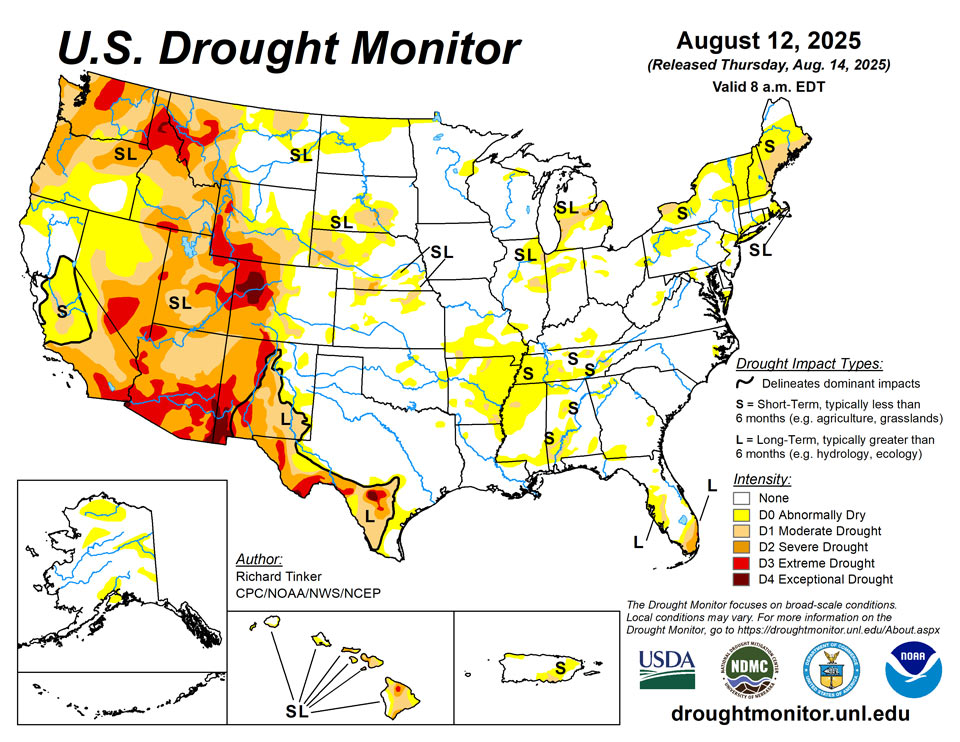
August 14, 2025 - Intensifying short-term rainfall shortages led to expanding and intensifying dryness and drought over much of the Lower Mississippi Valley, Ohio Valley, Tennessee Valley, Northeast, and parts of the Deep South, southern Plains, central Arizona, and the central Rockies. Meanwhile, a second consecutive week with moderate to heavy precipitation led to areas of improvement in the South Atlantic States from the Carolinas through Florida, across northern reaches of the Rockies and Plains, and over parts of the central Great Plains. The heaviest amounts (8 to 11 inches) doused areas in southeast Wisconsin from central Washington and Ozaukee Counties southward through much of north and central Waukesha and Milwaukee Counties. Meanwhile, 6 to 8 inches were dropped on a broader section of southeast Wisconsin as well as a few patches across southeast South Dakota, the Carolinas Piedmont and adjacent southern Appalachians, the coastal Carolinas, north-central Florida, the central Florida Peninsula, and interior southeast Florida.
Northeast
A few small areas of moderate to heavy rain affected part of upstate New York, southern Vermont, and a few adjacent sites, but most of the Region recorded little or no rainfall. As a result, precipitation deficits persisted or increased. Temperatures averaged a few degrees F above normal near the Great Lakes, in the St. Lawrence Valley, and across central and north New England. Farther south, subnormal temperatures prevailed for a second consecutive week in the central Appalachians and mid-Atlantic. The warm and dry conditions across most of the Northeast Region allowed for broad expansion and intensification of dryness and drought. Moderate drought was introduced across southern Maine, continued to affect Cape Cod, and expanded slightly in portions of far western and northern New York. Abnormally dry (D0) conditions broadly expanded across central Maine, New Hampshire and Vermont, much of Upstate New York, and several patches across Pennsylvania, New Jersey, Maryland, and eastern West Virginia. Abnormal dryness in and near Baltimore City remained unchanged from last week. According to the U.S. Department of Agriculture (USDA), topsoils were short or very short of moisture across two-thirds of Maine (up from 3 percent 5 weeks ago), three-quarters of Vermont (from 18 percent in early July), two-thirds of New York (up from 15 percent), 30 percent of Pennsylvania (from 12 percent), and more than half of Maryland (from 22 percent).
Southeast
The rainfall pattern varied sharply across the Region last week. Moderate to heavy rain, with amounts of 3 to 5 inches fairly common in some areas, soaked the Piedmont and adjacent Appalachians of the Carolinas, far southern Virginia, the coastal Carolinas, eastern Georgia, peninsular Florida, and the immediate central Gulf Coast. Lesser amounts from one-half to locally over 2 inches were reported in most other locations across Georgia, the Florida Panhandle, southeastern Alabama, and interior southern Louisiana. Other areas were drier with little or no precipitation reported, specifically across northern Virginia, the southernmost Appalachians, northwestern Georgia, and most locations across Alabama and Mississippi. The heavy rains brought an end to abnormal dryness across almost all of the Carolinas in addition to parts of central and southwestern Georgia, and parts of northern and peninsular Florida. In southernmost Florida, extreme drought (D3) persisted in southeastern Broward County, but D0 to D2 conditions improved somewhat in other parts of this area. In contrast, lesser amounts of rain fell in a band from Polk County southward through DeSoto County, where increasing moisture deficits led to the introduction of moderate drought (D1). Meanwhile, D0 conditions persisted and expanded across significant parts of Mississippi and Alabama, with pockets of moderate drought (D1) introduced in some of the drier areas. Most areas across Alabama and Mississippi have seen very low rainfall totals for the past 4 to 5 weeks following at least 1 to 2 months of near- to above-normal rainfall. In combination with somewhat hotter than normal summertime conditions recently, surface moisture depletion has been steadily ramping up in these two states in concert with short-term precipitation deficits, setting the stage for quickly amplifying dryness and drought severity despite near- to above-normal precipitation on multi-month time scales in most locations. New abnormal dryness was also identified on the Virginia portion of the Delmarva Peninsula. According to USDA, topsoil moisture is short or very short across 59 percent of Mississippi (up from 31 percent in early July) and 27 percent of Alabama (up from 9 percent). Meanwhile, in South Carolina, the coverage of short or very short topsoil moisture declined from 35 percent in early July to 22 percent this week.
South
Patches of moderate to heavy rain were observed over southernmost Louisiana and adjacent Texas, much of the Red River (south) Valley, the southern Texas Panhandle, and the northern tier of Oklahoma. Other areas saw scattered to isolated showers that did not markedly improve any extant dryness. Similar to conditions in adjacent Mississippi, above-normal precipitation earlier in the summer ebbed beginning in early July, and significant short-term rainfall deficits have accumulated over the past several weeks although multi-month precipitation totals are generally near or above normal. In conjunction with hot summertime conditions, this has led to quickly-depleting surface moisture over much of Tennessee, Arkansas, and portions of Louisiana. As a result, D0 conditions have been introduced and expanded rapidly. Farther west, less widespread short-term moisture deficits led to several patches of new D0 this week in western Arkansas, Oklahoma, and northeastern Texas. Farther south and west, some D0 and D1 expansion was noted in Deep South Texas, but dryness and drought were essentially unchanged across New Mexico and the remainder of Texas. USDA indicated that short or very short topsoil moisture covered 60 percent of Tennessee and 80 percent of Arkansas (up from 18 and 39 percent, respectively, in early July). The proportion of the Tennessee cotton crop in poor or very poor condition increased from 12 percent in early July to 26 percent last week.
Midwest
Conditions varied substantially across the Region last week. Heavy rains doused much of Iowa and significant parts of Minnesota, Wisconsin, and the Upper Peninsula of Michigan last week. A few inches to nearly one foot of rain pounded much of the southern tier of Wisconsin and several swaths in other parts of these areas. Meanwhile, more-scattered moderate to locally heavy amounts were observed in other parts of Wisconsin and Minnesota as well as portions of the western Lower Peninsula of Michigan, the northern and western parts of Missouri, and northwestern Illinois. In contrast, rainfall was light and patchy to isolated at best farther east, including most of Kentucky, Indiana, and Ohio. Much of the heaviest rain fell on areas already out of dryness and drought, so improvement was limited to parts of northern Minnesota and northwestern Illinois while persisting or increasing dryness was more common farther south and east, especially over southern Missouri and adjacent areas, plus portions of the eastern and southern Great Lakes region. USDA indicated that the proportion of Michigan covered by short or very short topsoil moisture increased from 21 to 52 percent over the last 5 weeks.
High Plains
Rainfall varied in intensity across the High Plains Region once again this week, with abundant rainfall amounts falling on much of North Dakota, southern Nebraska, and some spots in Kansas leading to improved conditions. Some improvement was also noted in part of the southeast Wyoming High Plains. Meanwhile, less precipitation kept dryness and drought approximately unchanged across South Dakota, and allowed for areas of intensification for the second consecutive week in central and western parts of Colorado and Wyoming. A sizeable swath of northwestern Colorado deteriorated into exceptional drought (D4), and D2 to D3 conditions expanded in other areas over and near the higher elevations in western parts of the High Plains Region. Since early July, USDA indicated that the proportion of topsoils short or very short of moisture increased from 20 to 32 percent in Colorado, and from 52 to 63 percent of Wyoming. In Colorado, 19 percent of the corn crop is in poor or very poor condition (up from just 1 percent in early July) while in Nebraska, one-third of the oat crop is in poor or very poor condition (up from 5 percent in early July).
West
Heavy precipitation (one to locally multiple inches in most areas) prompted significant areas of improvement across northern and part of western Montana as well as portions of northern Idaho. Farther south, a few weeks of deficient monsoonal rainfall and above-normal temperatures prompted deterioration in D1 to D3 conditions across southwestern Montana, several swaths across Utah, and a few areas in Arizona and eastern Nebraska. In addition, conditions deteriorated from moderate to severe drought (D1 to D2) in part of northwestern Washington. In other parts of the West Region, dryness and drought was unchanged compared to last week. Outside the northern tier of the Region, very little precipitation was reported outside several tenths to about an inch in southeastern Arizona. The proportion of rangelands in poor or very poor condition increased in the last 5 weeks from 32 to 49 percent in Utah, from 22 to 44 percent in Washington, and from 10 to 34 percent in Idaho. Over half of the Washington spring wheat crop is in poor or very poor condition compared to just 17 percent in early July. During this period, the proportion of Montana spring wheat in poor or very poor condition increased from 37 to 47 percent. USDA also indicated that 53 percent of the Washington barley crop is in poor or very poor condition, compared to just 14 percent in early July.
Caribbean
Heavy rainfall affected portions of western Puerto Rico and scattered areas farther east, sufficient to alleviate D0 conditions along some of the southwest coastal areas, plus portions of the eastern and south-central sections of the Commonwealth, including portions of the San Juan metro area. Meanwhile, precipitation deficits continue to build in the southeastern and interior east-central areas. Moderate drought (D1) was introduced in Salinas, Guayama, and eastern Coamo Municipalities, and abnormal dryness (D0) was introduced in several municipalities to the north and northwest.
Another week of hot, generally dry weather in the U.S. Virgin Islands led to no changes in the depiction of abnormal dryness (D0-S on St. John) and moderate drought (D1-S on St. Thomas and St. Croix). Recent rainfall has been slightly heavier on St. John, with an observation site at Windswept Beach receiving 2.20 inches during the first 11 days of August. Windswept Beach’s 3-month Standardized Precipitation Index (SPI) supports St. John’s D0 designation. Despite St. John’s rain, depth to water at the U.S. Geological Survey’s Susannaberg DPW 3 well increased by August 11 to more than 13.2 feet, which is the greatest value since October 30, 2023, when the territory was emerging from a significant drought. Meanwhile, 1- and 3-month SPI values for various locations on St. Thomas and St. Croix were supportive of D1-S, with increasing depths to groundwater and variable stress on vegetation providing additional evidence of moderate drought.
Pacific
In western Alaska, significant rainfall led to a reduction in D0 coverage there. In southcentral parts of the state, D0 was eliminated in a heavily-populated part of the Anchorage area. Meanwhile, based primarily on 3-month precipitation percentiles, there was a bit of a reconfiguration in the pattern of D0 coverage across the northeast Interior. The fire weather build-up index (BUI) is significantly elevated over the Yukon Flats, so the D0 there is unchanged. Unremarkable conditions on the North Slope and southeast Interior kept D0 there intact as well.
Fairly typical summertime conditions prevailed across the islands, with some rainfall observed in windward areas. As a result, conditions remained generally unchanged except in parts of southern and northeastern Oahu (including Honolulu) where conditions deteriorated from abnormal dryness (D0) into moderate drought (D1). Currently, scattered areas of D0 and D1 exist in the northwestern half of the state while more severe dryness covers most areas to the south and east, with broad areas topping out at D3 in northern interior parts of the Big Island.
In recent weeks, frequent and occasionally heavy showers across the U.S.-Affiliated Pacific Islands have eased or eliminated drought concerns, except in portions of the Republic of the Marshall Islands (RMI). By August 12, moderate drought (D1-S) in the RMI was limited to Utirik and Wotje, while abnormal dryness (D0-S) was confined to Kwajalein. Elsewhere in the RMI, Majuro’s reservoirs are nearly full, with storage increasing to more than 33.9 million gallons (94% of capacity) by August 12. On that date, neither dryness nor drought was being reported in the Federated States of Micronesia (FSM), the Mariana Islands, the Republic of Palau, and American Samoa. In the FSM, Yap has recently been one of the drier locations (less than an inch of rain falling in each of the last 3 weeks), although recent first-hand reports indicated that water supplies remain adequate.
Looking Ahead
From August 14 to 18, heavy rain (2 to locally 5 inches) is forecast in the higher elevations and coastal sections of Washington and Oregon, and also from the eastern Upper Mississippi Valley through much of the Great Lakes. At least several tenths of an inch of rain, with isolated totals near 2 inches, in areas commonly affected by the late summer and autumn monsoon in the Southwest and higher elevations of central Colorado. Similar amounts are anticipated in the Lower Mississippi Valley, Gulf Coast states, interior Southeast, South Atlantic States, coastal Northeast, northern Plains, eastern Great Lakes, and lower elevations of Washington and western Oregon. Light to locally moderate amounts potentially approaching an inch are expected in the Ohio Valley and scattered locations across the Rockies. Meanwhile, little or no precipitation is forecast across California, the Great Basin, the northern Rockies, the central and southern Plains, and the Middle Mississippi Valley. The National Hurricane Center is forecasting Tropical Storm Erin to move northwestward while strengthening into a major hurricane by the end of the period. Most guidance keeps the system east of the Bahamas and the East Coast, but there is a lot of uncertainty in any forecast hurricane track 3 to 5 days in advance. Rough surf and high waves may impact the East Coast and the Bahamas even if the storm stays well out to sea. Generally above-normal should prevail from the Appalachians westward through central and northern sections of the Plains and Rockies, as well as the coastal Northeast. Temperatures should average closer to normal over the Southeast, the mid-Atlantic, and southern portions of the Plains and Rockies. Cooler than normal weather should be confined to the Great Basin and West Coast States.
The Climate Prediction Center’s 6-10 day outlook (valid August 19-23, 2025) features significant uncertainty in the precipitation outlook. Odds for above-normal precipitation exceeding 40 percent are found in much of southern Arizona and the northern High Plains, and nowhere else. There are, however, fairly broad areas with slightly enhanced chances (33 to 40 percent) for wetter than normal wetter; specifically, from the portions of the Southwest typically affected by the late summer and autumn monsoon through the central and northern High Plains, and the northern Great Plains. Similar odds favoring above-normal precipitation also prevail across the southern Great Plains, the Lower Mississippi Valley, the interior Southeast, the Carolinas, the mid-Atlantic, and the coastal Northeast. Wetter than normal weather is also slightly favored across the northern half of Alaska. Meanwhile, odds lean towards below-normal rainfall in the Northwest and the northern Intermountain West, the Great Lakes, and the St. Lawrence Valley and adjacent New England. Drier than normal conditions are also favored along the southern tier of Alaska while near-normal amounts are expected across Hawaii. Meanwhile, warmer than normal weather is favored over the western half and southeastern quarter of the Contiguous United States, with odds reaching 60 to 80 percent in the central and northern High Plains, the Rockies, and the Florida Peninsula. Unusually warm weather is also favored across the southern half of Alaska, and Hawaii. Subnormal temperatures are favored over the eastern Great Lakes, mid-Atlantic, and Northeast.
Author(s):
Richard Tinker, NOAA/NWS/NCEP/CPC
Brad Rippey, U.S. Department of Agriculture
Dryness Categories
D0 Abnormally Dry—used for areas showing dryness but not yet in drought, or for areas recovering from drought.
Drought Intensity Categories
D1 Moderate Drought
D2 Severe Drought
D3 Extreme Drought
D4 Exceptional Drought
Drought or Dryness Types
S Short-term, typically less than 6 months (agriculture, grasslands)
L Long-term, typically more than 6 months (hydrology, ecology)
SL Area contains both short- and long-term impacts
Source: National Drought Mitigation Center
