


Update: California Dixie Fire Tuesday, August 10, 2021 Updates
Update: California Dixie Fire Community Meeting Evening Video Update for Monday, August 9, 2021
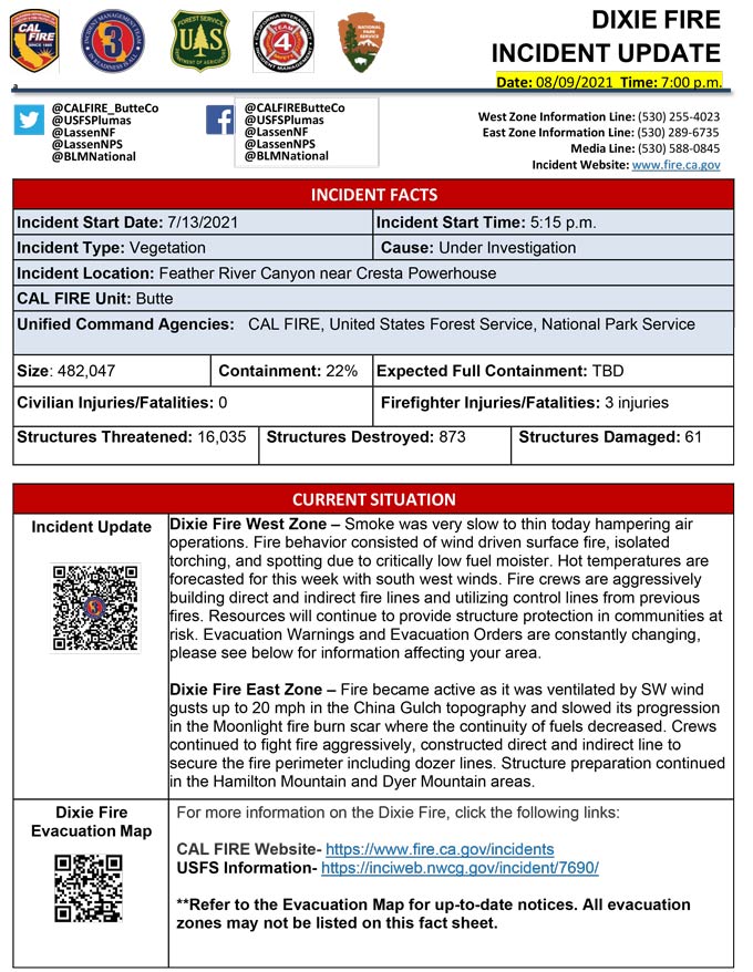
Evening Update Per CAL FIRE: California Dixie Fire is at 482,047 Acres, with 22% Containment for Monday evening.

MODIS map of the Dixie Fire in Butte and Plumas Counties on Monday at 5:15 A.M PST
Note: 1,200 Pixels Wide - Note: Older Yellow not shown
MODIS Active Fire Mapping Program Frequently Asked Questions
Update: Plumas County Sheriff's Office Announces Dixie Fire Road Evening Updates for Monday, August 9, 2021
Update: Plumas County Sheriff’s Office Reminds Dixie Fire Evacuees to Remain Out of Evacuation Order Zones
Update: Dixie Fire West Zone Operations Morning Briefing Video For Monday, August 9, 2021
Update: Dixie Fire East Zone Operations Morning Briefing Video for Monday, August 9, 2021
Update: Smoke/Air Quality Outlook for the Dixie Fire in the Eastern Sierra for Monday, August 9
Update: California Dixie Fire Infrared Map for Monday, August 9, 2021 - Interpreted Acreage: 479,845
August 9, 2021 - Dixie Fire is 489,287 acres and 21% contained for Monday morning.
Update 8:30 A.M. CAL FIRE
'Click' here to view full PDF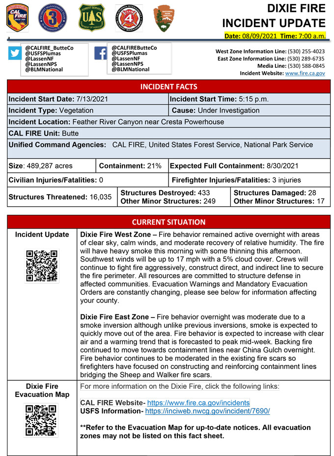
Basic Information
| Current as of | 8/9/2021, 6:50:41 AM |
| Incident Type | Wildfire |
| Cause | Under Investigation |
| Date of Origin | Tuesday July 13th, 2021 approx. 05:15 PM |
| Location | Feather River Canyon near Cresta Powerhouse and Lake Almanor. |
| Incident Commander | CALFIRE Incident Management Team 1 CA Interagency Incident Management Team 4 National Park Service |
| Incident Description | Wildfire |
| Coordinates | 39.819 latitude, -121.419 longitude |
Current Situation
| Total Personnel | 5,137 |
| Size | 489,287 Acres |
| Percent of Perimeter Contained | 21% |
| Estimated Containment Date | Friday August 20th, 2021 approx. 12:00 AM |
| Fuels Involved |
Timber (Litter and Understory) Timber (Grass and Understory) Brush (2 feet) Fuel moistures are historically low, ERCs and BI are in the 97-99% |
| Significant Events |
Observed Fire Behavior or Significant Events for the Time Period Reported (describe fire behavior using accepted terminology. For non-fire incidents, describe significant events related to the materials or other causal agents): Active Group Torching Uphill Runs Long-range Spotting Narrative: Fire behavior overnight remained active, though under clearer skies, calm winds, and decent RH recovery. Numerous spots developed outside the line. Firing operations began on the A21 Road. |
Outlook
| Planned Actions |
Construct direct and indirect line to secure fire perimeter. Unable to staff contingency lines due to all resources committed to Fire Front Following, providing structure defense in surrounding impacted communities. Provide structure defense in communities at risk: Chester, Hwy 36 corridor, Hwy 89 Corridor, Paxton, Greenville, Jonesville, Crescent Mills, Taylorsville, Prattville, Canyon Dam, Butte Meadows, Bucks Lake, Meadows Valley, Rush Creek, Warner Valley, Pecks Valley, Williams Valley, Hunt Canyon, and Greater Almanor area. Continue tactical patrol in the communities impacted by fire. |
| Projected Incident Activity |
12 hours: The fire will have heavy smoke in the morning with some thinning expected in the afternoon. Slightly warmer today, with temperatures in the mid 80s with minimum humidity dropping slightly to 11-20% during the day. Expect a Moderate risk burn environment due to moderate temps, low RH and extremely receptive fuels. The atmosphere will be somewhat unstable with a Haines of 4. Forecasted winds will be SW17 MPH with 5% cloud cover. Fire behavior will consist of wind-driven surface fire, isolated torching and spotting. 24 hours: Slightly cooler today. Expect a Moderate risk burn environment due to moderate temps, low RH and extremely receptive fuels. The atmosphere will be somewhat unstable with a Haines of 4. Forecasted winds will be SW17 MPH with 5% cloud cover. Fire behavior will consist of fuel driven surface fire, isolated torching and spotting. Moderate overnight recoveries may provide opportunity for line construction and/or firing operations. Local thresholds will be exceeded. Expect comparable fire behavior as the previous operational period. The fire will most likely spread to the North and Northwest due to sustained SW winds. 48 hours: Temperatures will be in the high 80's today and will heat up over the next few operational periods. 5% cloud cover forecasted during the burning period. Fire behavior has the potential to revert to very active with the diminishing smoke shading. Fire behavior would include wind driven surface fire, group torching, crown runs with alignment and spotting. Moderate overnight recoveries may provide opportunity for line construction and/or firing operations. Local thresholds will be exceeded. Expect an increase in fire activity with clear air. Fire has entered Lassen National Park and is expected to continue burning north through the park. 72 hours: Similar profile as the previous operational period. Expect comparable fire behavior as the previous operational period. Forecasted hot and dry weather through the end of the week. Anticipated after 72 hours: Expect comparable burning conditions. Temperatures will remain in the high 80s and low 90s. |
| Remarks |
California Interagency Incident Management Team 4 (CIIMT 4) is in command of the East Zone. CALFIRE IMT 3 is in command of the West Zone starting at 0700. State DPA: 60,945 Federal DPA: 377,366 NPS DPA: 8,411 |
Current Weather
| Weather Concerns |
EAST ZONE: Overnight and this morning, light and variable winds prevailed across the fire. Relative humidity range dramatically with lower elevations exhibiting good recovery with poor recovery at higher elevations. For today, conditions are expected to be less smoky. Afternoon temperatures will be a few degrees warmer while relative humidity drops into the teens. Light and variable winds this morning will shift to a south and upcanyon direction this afternoon with gusts 15-25 mph. WEST ZONE: Smoke stayed over the fire through early afternoon before some clearing allowed the fire to begin to ventilate. Temperatures from the mid 70s to mid 80s due to smoke shading with humidity values higher, ranging from 15-25%. Thick smoke forecast to settle over the fire tonight with light downcanyon winds. The tail end of a dry cold front passes over the region on Sunday afternoon leading to increasing west winds that will help to mix the smoke layer out much layer with an expected increase in fire activity. West wind gusts from 20-30 mph will be adverse to the eastern edges of the fire. Long range forecast remains hot and dry. Observed Weather Conditions: Smoke skies Wind Speed / Max Gust 5-10 mph gusts 18 mph. Temps: 78 higher elevations covered in smoke, mid 80s sunny portions of Branch V/VII. Direction Southwest RH 18-28% Forecasted Weather for Saturday Operational Period: Morning smoke lifting by midday. Wind Speed / Max Gust 6-12 mpg gusts 20-30 mph exposed ridges. Directions: Light then westerly after 1300 hours RH 15-25% |
Click here for: California Dixie Fire Sunday, August 8, 2021 Updates
