


Click here for: California Dixie Fire Wednesday, August 11, 2021 Updates
Update: California Dixie Fire Evening Operations East Zone Update Video for Tuesday, August 10, 2021
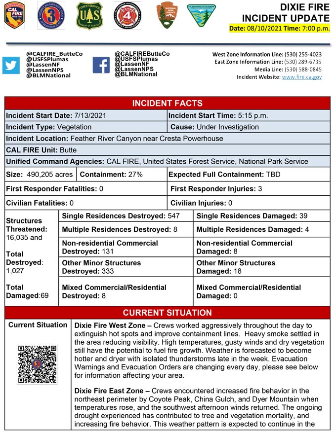
Evening Update Per CAL FIRE: California Dixie Fire is at 490,205 Acres, with 27% Containment for Tuesday evening.
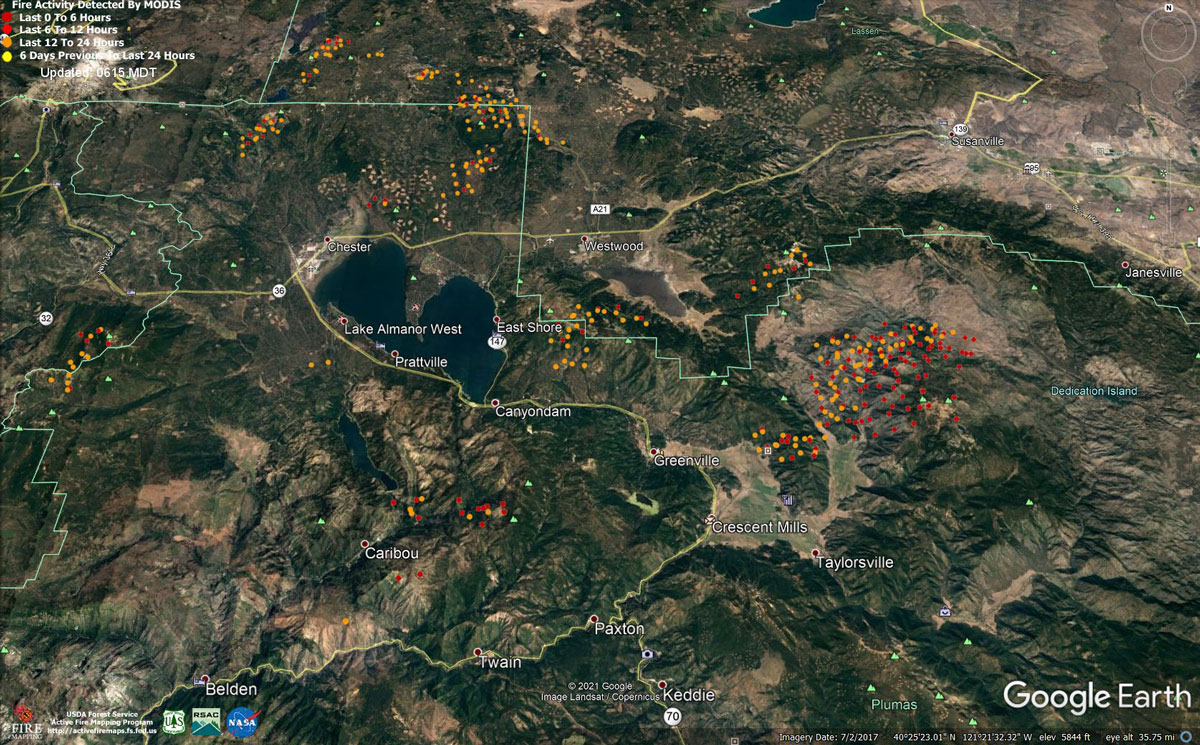
MODIS map of the Dixie Fire in Butte and Plumas Counties on Tuesday at 5:15 A.M PST
Note: 1,200 Pixels Wide - Note: Older Yellow not shown
MODIS Active Fire Mapping Program Frequently Asked Questions
Update: Plumas County Sheriff’s Office Issues Road Closure Updates for the Dixie Fire on August 10, 2021
Update: CAL FIRE Issues Evacuation Update for the California Dixie Fire in Butte County
Update: All the Evacuation Orders in Butte County due to the Dixie Fire have been reduced to Evacuation Warnings. All other warnings remain in place in Butte County.
Update: Dixie Fire East Zone Operations Morning Briefing Video for Tuesday, August 10, 2021
Update: Dixie Fire Morning Briefing Video for Tuesday, August 10, 2021
Update: Smoke/Air Quality Outlook for the Dixie Fire in the Eastern Sierra for Tuesday, August 10
August 10, 2021 - Dixie Fire is 487,764 acres and 25% contained for Tuesday morning.
Update 8:30 A.M. CAL FIRE
'Click' here to view full PDF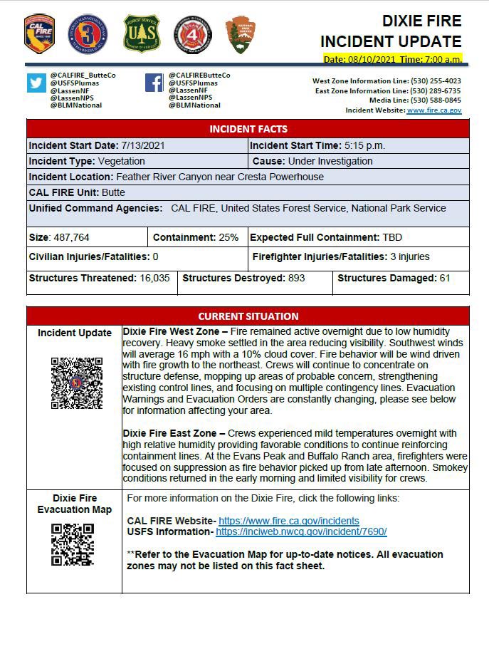
Basic Information
| Current as of | 8/10/2021, 6:29:01 AM |
| Incident Type | Wildfire |
| Cause | Under Investigation |
| Date of Origin | Tuesday July 13th, 2021 approx. 05:15 PM |
| Location | Feather River Canyon near Cresta Powerhouse and Lake Almanor. |
| Incident Commander | CALFIRE Incident Management Team 1 CA Interagency Incident Management Team 4 National Park Service |
| Incident Description | Wildfire |
| Coordinates | 39.819 latitude, -121.419 longitude |
Current Situation
| Total Personnel | 5,997 |
| Size | 482,047 Acres |
| Percent of Perimeter Contained | 22% |
| Estimated Containment Date | Monday August 30th, 2021 approx. 12:00 AM |
| Fuels Involved |
Timber (Litter and Understory) Timber (Grass and Understory) Brush (2 feet) Fuel moistures are historically low, ERCs and BI are in the 97-99% |
| Significant Events |
Observed Fire Behavior or Significant Events for the Time Period Reported (describe fire behavior using accepted terminology. For non-fire incidents, describe significant events related to the materials or other causal agents): Active Group Torching Uphill Runs Long-range Spotting Narrative: Moderate Risk burn environment. Fire continues to progress northeast in the very dry, very receptive fuels. Heavy smoke cover is limiting air operations but shows limited effects on fire behavior with single and group tree torching contributing to fire spread. Variable terrain is hindering control efforts and channeling the light winds that are in the fire area. Ember cast and short-range spotting continue to challenge control lines. Expect fire behavior to increase with clear skies. Our current weather is forecasted to become hotter and dryer throughout the week. All fuels remain available. Forecasted SW winds will be a contributing factor in fire spread. Fuel moistures remain critically low for both live and dead. The Energy Release Component is above the 87th percentile and climbing. All thresholds for the Plumas Central have been exceeded. |
Outlook
| Planned Actions |
Construct direct and indirect line to secure fire perimeter. Unable to staff contingency lines due to all resources committed to Fire Front Following, providing structure defense in surrounding impacted communities. Provide structure defense in communities at risk: Chester, Hwy 36 corridor, Hwy 89 Corridor, Paxton, Greenville, Jonesville, Crescent Mills, Taylorsville, Prattville, Canyon Dam, Butte Meadows, Bucks Lake, Meadows Valley, Rush Creek, Warner Valley, Pecks Valley, Williams Valley, Hunt Canyon, and Greater Almanor area. Continue tactical patrol in the communities impacted by fire. Protect threatened areas of Janesville, Indicator Peak and Loan Peak. Firing operations will continue in the West Zone-Division Juliet, from Humboldt Ridge to Hwy 36, as weather and staffing allows. Approximately 50% of the firing operations were completed overnight. Critical resource needs are essential to the success of the firing operations. |
| Projected Incident Activity |
12 hours: Moderate overnight conditions. Expect the fire activity to continue to decrease through the morning hours. The valleys will see slight RH recovery. Potential for crews to make headway on building containment lines and firing operations around the North and Northeast areas of the fire in accordance with NE winds (ridgetop 4-8 MPH). 24 hours: Slightly warmer temperatures expected. Expect a Moderate risk burn environment due to higher temps, low RH and extremely receptive fuels. The atmosphere will be somewhat unstable with a Haines of 5. Forecasted winds will be SW16 MPH with 10% cloud cover. Fire behavior will consist of wind-driven surface fire, isolated torching and spotting. Moderate overnight recoveries may provide opportunity for line construction and/or firing operations. Local thresholds will be exceeded. Expect comparable fire behavior as the previous operational period. The fire will most likely spread to the North and Northeast due to sustained SW winds. 48 hours: Temperatures will be in the high 90s today and will heat up over the next few operational periods. 10% cloud cover forecasted during the burning period. Fire behavior has the potential to transition to very active. Fire behavior would include wind driven surface fire, group torching, crown runs with alignment and spotting. Moderate overnight recoveries may provide opportunity for line construction and/or firing operations. Local thresholds will be exceeded. Expect an increase in fire activity with clear air. 72 hours: Temperatures will be in the triple digits over the next few shifts. Increased potential for dry thunderstorms through the end of the week. Expect comparable fire behavior as the previous operational period. Forecasted hot and dry weather through the end of the week. Anticipated after 72 hours: Expect similar burning conditions. Temperatures will remain in the mid 90s. Models indicate potential moisture in the atmosphere with limited confidence. |
| Remarks |
California Interagency Incident Management Team 4 (CIIMT 4) is in command of the East Zone. CALFIRE IMT 3 is in command of the West Zone starting at 0700. State DPA: 60,945 Federal DPA: 377,366 NPS DPA: 8,411 |
Current Weather
| Weather Concerns |
EAST ZONE: Light and variable winds prevailed overnight with moderate humidity recoveries ranging from 35 to 65% For today, expect warmer temperatures and minimum RH in the low teens. Winds will be light and variable in the morning before shifting to the SW in the afternoon with gusts around 10 to 15 mph. Additionally, increased instability in the atmosphere will lead to additional rising air, helping to fuel pyrocumulus development. WEST ZONE: Smoke filled back in early during the evening hours with winds becoming down slope down canyon. Temperatures dropped into the 70s by midnight with humidity recovering into the mid to upper 20th percentile. High pressure continues to build over the incident and will be the dominant weather feature through mid-week. This will result in warming and drying with winds light and primarily terrain driven, averaging less than 10 MPH. Smoke will remain hard to scour out and will moderate weather conditions somewhat. Moisture levels will be increasing late in the week with isolated and thunderstorms are not out of the realm of possibility. |
Click here for: California Dixie Fire Monday, August 9, 2021 Updates
