


Update: Dixie Fire West Zone Briefing & Community Meeting Video on Tuesday, August 24, 2021
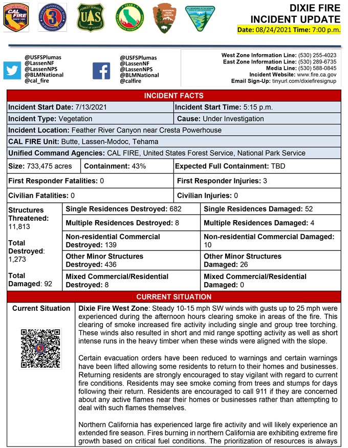
Evening Update Per CAL FIRE: California Dixie Fire is at 733,475 Acres, with 43% Containment, and 5,815 personnel assigned for Tuesday evening.
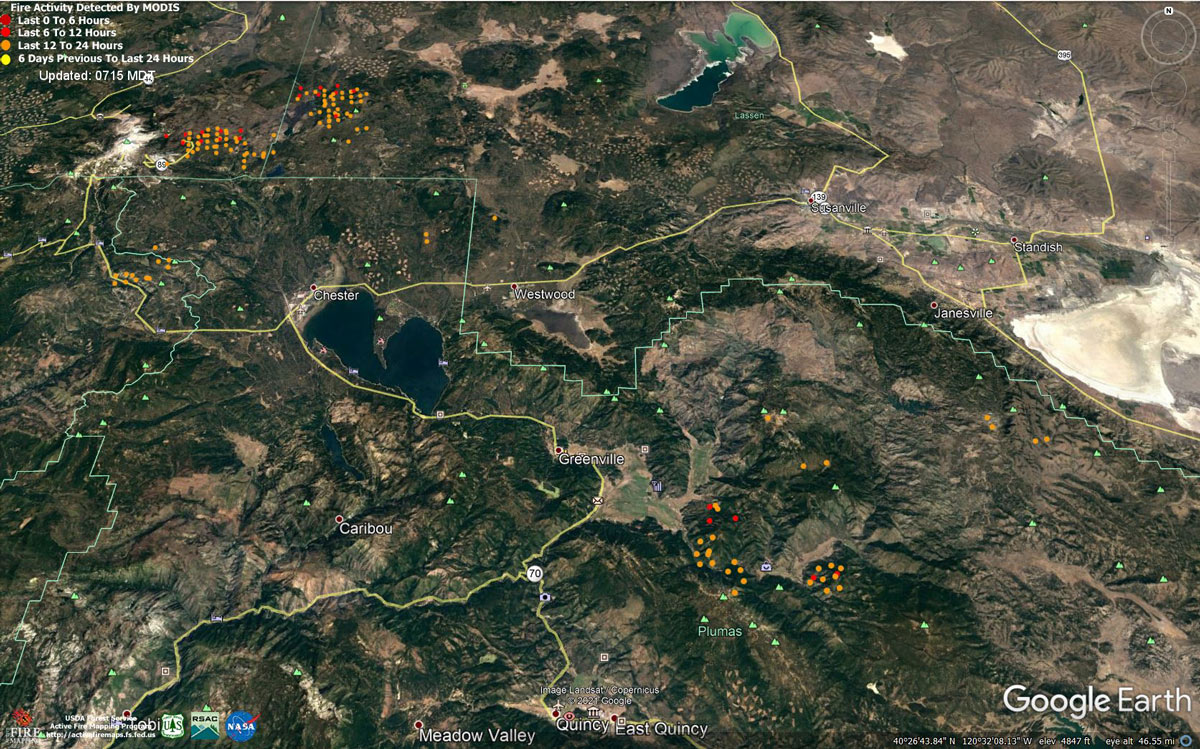
MODIS map of the Dixie Fire on Tuesday at 6:15 A.M PST
Note: 1,200 Pixels Wide - Note: Older Yellow not shown
MODIS Active Fire Mapping Program Frequently Asked Questions
Update: Dixie Fire Operational Updates from Lassen National Forest for Tuesday, August 24, 2021
Update: Dixie Fire Evacuation Information & Updates for Tuesday, August 24, 2021
Update: Evacuation Order and Warnings Reduced for Some Areas of the Dixie Fire for August 24, 2021
Update: Fraud Alert!!!
We have received a number of reports related to a phone scam/ fraud. The caller is identifying himself as a Lassen County Sheriff’s Deputy and using names of local deputies. The caller solicits payment for outstanding warrants. The number will look like it originates from the Sheriff's Office. The Sheriff's Office does not take payments for fines in the form of gift cards, nor do we make collection calls. These calls are fraudulent. Do not make payment to the caller.
Source: Lassen County Sheriff's Office
Update: Dixie Fire West Zone Briefing & Virtual Community Meeting Set for 7:00 P.M. Tonight, August 24, 2021
Update: Dixie Fire East Zone Operations Morning Briefing Video for Tuesday, August 24, 2021
Update: Dixie Fire Tuesday, August 24, 2021 Morning Operations Briefing Video
Update: Dixie Fire - Fire Behavior Morning Briefing Video for Tuesday, August 24, 2021
Update: Smoke/Air Quality Outlook for the Dixie Fire in the Eastern Sierra for Tuesday, August 24, 2021
Update: Dixie Fire Morning Briefing Video for Tuesday, August 24, 2021
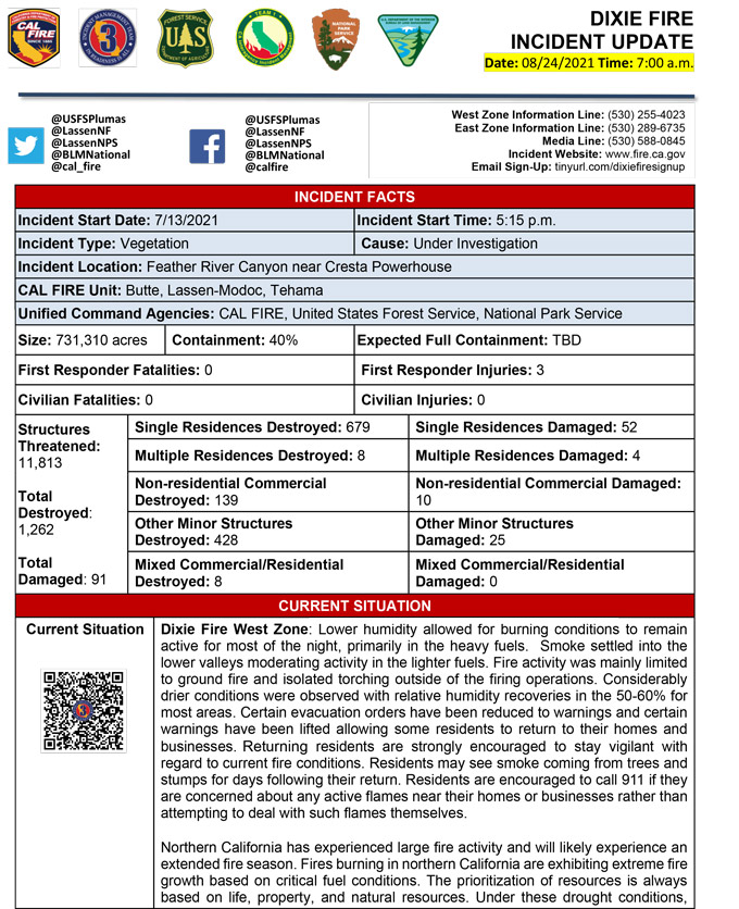
August 24, 2021 - Dixie Fire is 731,310 acres and 41% contained for Tuesday morning. (Not 40% Per CAL FIRE Update)
Update 7:20 A.M. CAL FIRE
Basic Information
| Current as of | 8/24/2021, 6:14:05 AM |
| Incident Type | Wildfire |
| Cause | Under Investigation |
| Date of Origin | Tuesday July 13th, 2021 approx. 05:15 PM |
| Location | Feather River Canyon near Cresta Powerhouse and Lake Almanor. |
| Incident Commander | Billy See, CALFIRE IMT 3 Jerry McGowan, CIIMT 1 Jay Lusher, NPS/BLM |
| Incident Description | Wildfire |
| Coordinates | 39.819 latitude, -121.419 longitude |
Current Situation
| Total Personnel | 5,918 |
| Size | 731,310 Acres |
| Percent of Perimeter Contained | 41% |
| Estimated Containment Date | Thursday September 30th, 2021 approx. 12:00 AM |
| Fuels Involved |
Fuel moistures are historically low, ERCs and BI are in the 97-99%. Northern California remains under a Fuels and Fire Behavior Advisory. |
| Significant Events |
Active: Uphill Runs Group Torching Short-range Spotting Narrative: Lower humidity allowed for burning conditions to remain active for most of the night, primarily in the heavy fuels. Smoke settled into the lower valleys, moderating activity in the lighter fuels. Fire activity was mainly limited to ground fire and isolated torching outside of the firing operations. |
Outlook
| Planned Actions |
Construct direct and indirect line to secure fire perimeter. Direct line construction in the Westwood area will require a heavy resource presence. Provide for service calls within communities impacted by the fire: Chester, Hwy 36 corridor, Hwy 89 Corridor, Hwy 395 corridor, Paxton, Greenville, Jonesville, Crescent Mills, Taylorsville, Prattville, Canyondam, Butte Meadows, Bucks Lake, Meadows Valley, Rush Creek, Warner Valley, Pecks Valley, Williams Valley, Hunt Canyon, Susanville, Janesville, and the Greater Almanor area. Structure protection and heavy mop up continues in Warner Valley, Cradle Valley, and Wilcox Valley. Protect threatened areas of Janesville, Indicator Peak and Loan Peak. Heavy mop and patrol of communities impacted by the fire front. "Make Safe" for repopulation. Resources will be working from Dyer Mountain east to Mountain Meadow Reservoir utilizing direct line to complete action in that area. Continued mop up of and patrol of 1,000-hr fuels will require a significant amount of resources due to the volume of fuels and the steep and rugged terrain. Priority areas include structure protection in Janesville/Milford area, the Hwy 36 corridor, and the Mill Creek drainage. Fire is well established in the Mill Creek Plateau. Continue direct and indirect line construction to prevent the fire from crossing the Mill Creek drainage and impacting the communities of Mill Creek and Mineral. If the fire were to become established in the Mill Creek drainage, large fire growth is expected. Resources in the Genesee Valley area continue protect the community of Taylorsville and limit spread from spot fires and active flanks. Resources continue to hold the Hwy 36 corridor and monitor for spots across the highway. Continued holding actions and point protection of communities and critical infrastructure will require a significant resource presence for the next several operational periods. Tactics that utilize fewer resources are being implemented in the Lassen Sector. Firing plans are being developed for West Zone - Div K. |
| Projected Incident Activity |
12 hours: Temperatures will be in the 80's today. Forecasted winds continue out of the SW today, and unstable atmosphere with a Haines of 5. Fire behavior will consist of wind, slope, and fuel continuity alignment supporting surface fire spread, roll out, isolated torching and spotting. Moderate overnight recoveries may provide opportunity for line construction and firing operations. Expect comparable fire behavior as the previous operational period. Fire should have completed backing down Genesee Valley road today, continues to threaten many structures. 24 hours: Moderate Risk burn environment. Temperatures will be in the low 80's to low 90's today and will be similar over the next few operational periods. Fire behavior would include wind driven surface fire, group torching, crown runs with alignment and spotting. Moderate overnight recoveries may provide opportunity for line construction and firing operations. Local thresholds will be exceeded. Expect an increase in fire activity with clear air. 48 hours: Temperatures will be in the mid 80's over the next few shifts. Expect comparable fire behavior as the previous operational period. Forecasted hot and dry weather through the end of the week. 72 hours: Temperatures will be in the mid 80's over the next few shifts. Expect comparable fire behavior as the previous operational period. Forecasted hot and dry weather through the end of the week. Anticipated after 72 hours: Expect similar burning conditions. Temperatures will remain in the high 80's throughout the week. |
| Remarks |
Continuation of Box 4: California Interagency Incident Management Team 1(CIIMT 1)is in command of the East Zone. East Zone Unified Command Agencies: Plumas National Forest and Lassen National Forest CAL FIRE IMT3 is in command of the West Zone. West Zone Unified Command Agencies: Bureau of Land Management, CAL FIRE, Lassen National Forest, National Park Service Continuation of Box 25: The fire area is in portions of Butte, Lassen, Plumas, Shasta, and Tehama counties. Active fronts are in the Greater Lake Almanor area, Lassen NF, and Lassen NP, as well as on several private timber ownerships. Continuation of Box 31(J): Civilians in indoor temporary shelters - 59 Civilians in outdoor temporary shelters - 29 Continuation of Box 32(E): East Zone - 3 responder injuries West Zone - 3 responder injuries Continuation of Box 33: State of Emergency for Butte, Lassen, and Plumas counties was declared by Governor Newsom on July 23rd, 2021. Butte, Lassen, Plumas, and Tehama Counties have declared local emergencies. FMAG has been approved for Butte, Plumas, and Lassen Counties. The Plumas National Forest implemented Forest Order No. 05-11-00-21-18, effective from July 25, 2021, through September 30, 2021. The Lassen National Forest implemented Forest Order No. 06-21-07, effective from July 27, 2021, through September 30, 2021. Continuation of Box 38: Additional values at risk threatened: National Scenic and Historic Trails: Pacific Crest Trail, Bizz Johnson National Recreation Trail Inventory Roadless Area (IRAs): Bucks Lake (PNF), Butt Mountain (PNF), Chips Creek (LNF), and Cub Creek (LNF). Experimental Forests: Swain Mountain, Blacks Mountain. Research Natural Areas (RNAs): Green Island Lake (LNF), Soda Ridge (LNF), Cub Creek (LNF), Mount Pleasant (PNF). Air Quality impacts: Reno, Carson City, Susanville, Sparks, Fernley and Quincy. Airports impacted by TFR and smoke impacts: Rogers Field (Chester Airport), Ganser Field (Quincy Airport), Westwood Airport, Susanville Municipal Airport, Herlong Airport Wilderness: Bucks Lake Wilderness (PNF), Caribou Wilderness (LNF), Lassen Volcanic National Park Wilderness. Commercial timber ownerships: Sierra Pacific Industries, W.M. Beaty and Associates, Collins Pine. An estimated $1 Billion dollars of timber has already been destroyed with an additional $1 Billion still threatened. Total cumulative private timber loss -260,724 acres. Substantial losses of private and public timberlands have released decades of sequestered carbon, releasing it into the atmosphere with uncalculatable impacts to greenhouse gas accumulations. Waterways: Philbrook Lake (PG&E, LNF), North Fork of the Feather River (PG&E, PNF), Silver Lake (Drinking water, PNF), Thompson Lake (Drinking water, PNF), Butte Creek (T&E species: chinook and steelhead, PNF), Deer Creek (T&E species: chinook and steelhead), Oliver Lake (T&E species: Sierra-Nevada Yellow-legged Frog, LNF), Gold Lake (T&E species: Sierra-Nevada Yellow-legged frog, (PNF), Rock Lake T&E species: Sierra-Nevada Yellow-legged frogs, (PNF) Additional T&E species (not listed above): California Spotted Owl, Valley Elderberry Beetle, Shasta Crayfish, Cascades frog, California Red-Legged Frog, Bald Eagle, Golden Eagle, Grey wolf, Fisher, California wolverine, and Sierra Nevada red fox. |
Current Weather
| Weather Concerns |
Smoke settled into the area overnight. Considerably drier conditions were observed with relative humidity recoveries in the 50-60% for most areas. An upper-level trough will keep gusty southwesterly, higher elevation winds during the afternoon hours in the forecast for the next couple of days. Temperatures will remain near normal with RH dropping into the 15-20% range through Thursday. Temperatures are expected to rise above normal for the latter part of the week in addition to RH reaching critical levels during the day with poorer overnight recoveries. |
Click here for: California Dixie Fire Monday, August 23, 2021 Updates
