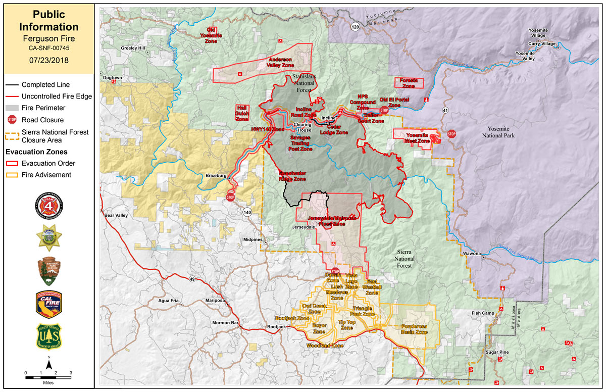
Monday Public Information Map
CLICK HERE FOR A LARGE MAP (3,000 Pixels Wide and 3MB)

Click here for the Sierra Sun Times Scanner
Reminder: Scanner Information is NOT Official
Click here for Sunday's Information on the Ferguson Fire
Update: 7:00 P.M. Ferguson Fire Near YNP in Mariposa County Monday Evening Update: 36,102 Acres with 16% Containment
Update 4:30 P.M. Ferguson Fire Community Meeting in Yosemite Valley on Tuesday, July 24, 2018
Update: 2:18 P.M. Sierra National Forest Afternoon Operational Update Video for the Ferguson Fire on July 23, 2018
Update: 2:17 P.M. Fire is at 32,484 Acres with 13% Containment.
Basic Information
|
Current as of |
7/23/2018, 2:17:36 PM |
|
Incident Type |
Wildfire |
|
Cause |
Unknown |
|
Date of Origin |
Friday July 13th, 2018 approx. 08:30 PM |
|
Location |
Highway 140 and Savages Trading Post |
|
Incident Commander |
Jay Kurth, California Interagency Incident Management Team 4(CIIMT4) |
|
Coordinates |
37.652 latitude, -119.881 longitude |
Current Situation
|
Total Personnel |
3,066 |
|
Size |
33,743 Acres |
|
Percent of Perimeter Contained |
13% |
|
Fuels Involved |
Brush and timber, burning is steep inaccessible terrain. |
|
Significant Events |
Hwy 140 is closed from 1.9 miles east of Midpines to the Cedar Lodge area MOTORISTS ARE ADVISED TO USE AN ALTERNATE ROUTE |
Outlook
|
Remarks |
CAIMT4 (Kurth) is in unified command with Billy See, CALFIRE and Doug Binnewies, Mariposa County Sheriff |
Update: 1:26 P.M. Forest Service Wildland Fire Air Quality Outlook of the Yosemite Area for July 23 - Includes Mariposa, Oakhurst and Yosemite
Update: 8:40 A.M. Forest Service Wildland Fire Air Quality Outlook for the Southern Sierra for Monday - Includes Mariposa, Oakhurst and Yosemite
Update: 6:00 A.M. 7:00 A.M. Ferguson Fire Near Yosemite National Park in Mariposa County Monday Morning, July 23, 2018 Update: 33,743 Acres with 13% Containment
Update: 4:50 A.M. Ferguson Fire Near Yosemite National Park in Mariposa County Monday, July 23 Operations Map
July 23, 2018 - The Ferguson Fire is burning on the Sierra National Forest near Yosemite National Park in Mariposa County.
Today at 11:00 A.M.
Live Streaming of Celebration of Life Service for HFEO Braden Varney on Monday, July 23, 2018
Sunday Evening Information
July 22, 2018 - Awahanee, CA. - The Ferguson Fire — burning on both the Sierra and Stanislaus national forests — grew to 32,484 acres with 6% containment.
As the fire moved north toward the Montgomery Gulch and Anderson Valley areas, the Mariposa County Sheriff’s Office issued a Mandatory Evacuation Order for residents of Old Yosemite Road in Groveland. Firefighters continued their defense of structures in the Jerseydale area and mop up work along the fire’s edge were safe to do so. Crews continued to strengthen the line that runs from El Portal southeast toward Wawona Road and Yosemite National Park with additional hose lays in preparation for future burnout operations. Firing operations in that area were planned for Sunday’s day shift but were halted because of adverse weather conditions.
The night shift will pick up where day crews left off by building indirect line east on Henness Ridge and crews are prepared to use these lines for firing operations when conditions become favorable. North of the Merced River, resources will improve direct line that is anchored in to the Merced River on the west side. Indirect line construction will continue, utilizing the Stanislaus National Forest road system where available.
South of the Merced River, firing operations from Sweetwater Ridge to the Merced River should be concluded. Mop up following firing operations will continue to strengthen control line on the west side of the fire.
The southeastern corner of the fire will continue to burn in the timbered areas of Granite Ridge, toward the Chowchilla Mountains. Resources have coordinated with Yosemite National Park to identify areas to establish indirect control lines.
Yosemite National Park remains open. For information on Yosemite National Park, go to: nps.gov/yose or call 209-372-0200.