Click here for Wednesday's Updates: KNP Complex Wildfires in Sequoia National Park Wednesday, October 6, 2021 Updates
October 5, 2021 - KNP Complex Fire in Sequoia National Park updates for Tuesday: 78,768 Acres with 11% Containment
Update: Please join us on Facebook for another Public Meeting tonight Tuesday, October 5 at 7:00 PM here is the link: Sequoia and Kings Canyon NPS Facebook Live
Update: Smoke/Air Quality Outlook for the KNP Complex Wildfires in Sequoia National Park for Tuesday, October 5, 2021
Update: 79,382 Acres with 11% Containment
Southwest Area Type 1 Incident Management Team 2
Dave Bales – Incident Commander
Acres: 79,382 acres
Containment: 11 %
Start Date: September 10, 2021
Cause: Lightning
Jurisdiction: Sequoia and Kings Canyon National Parks; Sequoia National Forest
Resources: 1,566 personnel including: 27 crews, 90 engines, 35 water tenders, 18 dozers and 13 helicopters
A Virtual Community Meeting will be held at 7:00 pm tonight at https://www.facebook.com/SequoiaKingsNPS/live_videos
Active fire behavior was observed over most of the fire yesterday, making a run as it became established in Redwood Creek on the northern end. Firefighters provided structure protection for Wilsonia, Hartland, Quail Flat, and Grant Grove along the northwest perimeter. The fire crossed Generals Highway near Redwood Mountain Grove and Stoney Creek, causing firefighters to temporarily move to safer locations. On the southern side of the fire, resources worked along the Mineral King Road to contain the spot fires from Sunday night. Firefighters also provided structure protection in Silver City and the Mineral King area. Aircraft were able to support ground resources with bucket drops on Monday once the smoke cleared enough to safely fly.
Today, firefighters will improve control lines along the northwest perimeter to keep the fire east of Hartland and protect Wilsonia, Hartland, Quail Flat, and Grant Grove Village. Resources are working at the Big Whistle area and around park structures to stop the fire from moving any farther north. Along Generals Highway, firefighters are patrolling established firelines near Big Baldy and construct firelines father east by Stoney Creek and Cabin Creek to prevent further spread to the northeast. Resources south of Morro Rock are connecting indirect lines back to established containment lines. On the southern perimeter of the fire, resources are working to contain the fire where it crossed Mineral King Road. Crews are working to keep the fire from progressing south toward Ash Mountain. Structure protection continues for Silver City, the Mineral King area, Three Rivers and Ash Mountain. Aviation assets are available to support firefighting efforts on the ground as visibility improves.
For public and firefighter safety, we ask if you are traveling along road systems near the fire are to please slow down, turn on your lights and watch out fire equipment on the road.
For more detailed information on Evacuation orders and Warnings you can visit:https://nifc.maps.arcgis.com/apps/webappviewer/index.html?id=4b2ac27b5c8943ed92c0e77aa94daca0
A ridge of high pressure finally begins to break down as a low-pressure trough approaches. This will allow a small increase in westerly winds aloft, bringing slightly better smoke mixing in the afternoon. Local winds will remain light, and terrain driven. Humidity levels will rise slowly, which will help to moderate fire behavior.
Information about how to prepare for evacuations can be found at https://www.readyforwildfire.org/
Sequoia and Kings Canyon National Parks are closed west of the Pacific Crest Trail and south of the ridgeline which lies north of Ionian Basin. In addition, the BLM Case Mountain Extensive Recreation Management Area and major portions of the Sequoia National Forest are also closed.
Communities surrounding the park and in the nearby region are being affected by smoke and the resulting poor air quality. Track your local air quality at https://www.wildlandfiresmoke.net/outlooks/FresnoCA.
Basic Information
| Current as of | 10/5/2021, 11:30:01 AM |
| Incident Type | Wildfire |
| Cause | Lightning |
| Date of Origin | Friday September 10th, 2021 approx. 07:00 AM |
| Location | Sequoia National Park |
| Incident Commander | David Bales |
| Incident Description | Complex |
| Coordinates | 36.567 latitude, -118.811 longitude |
Current Situation
| Total Personnel | 1,566 |
| Size | 79,382 Acres |
| Percent of Perimeter Contained | 11% |
| Fuels Involved |
Timber (Litter and Understory) Chaparral (6 feet) Short Grass (1 foot) |
| Significant Events |
Observed Fire Behavior: Extreme Uphill Runs Running Short-range Spotting Narrative: Fire behavior increased dramatically in the morning with the sunshine and poor overnight recovery. Extreme fire behavior was observed on the north end of the fire. |
Outlook
| Planned Actions |
Utilize direct and indirect tactics including firing operations, ground resources and heavy equipment. Conduct structure protection and mitigation efforts for National Park features (infrastructure, Headquarters, Museum, employee housing) and adjacent communities. Continued protection and mitigation measures for all sequoia groves within the fire area. When attributes of fire behavior are favorable to the landscape, allow fire to spread to aid in fuels reduction in around the groves. |
| Projected Incident Activity |
12 hours: Fire behavior will continue to be active to very active into the night with the lower humidity. Downslope winds will continue to influence fire movement. 24 hours: Humidity will increase enough to start to moderate fire behavior. Expect to see very active to active around the fire. 48 hours: Humidity will increase keeping the fire behavior to moderate to active. 72 hours: Moderate fire behavior can be expected with minimal growth. Anticipated after 72 hours: Higher humidity will continue to moisten fuels and lower the fire behavior. |
Current Weather
| Weather Concerns |
High pressure began to break down this morning, allowing more southwest flow to push smoke to the northeast. This brought more sunshine to the northwest side of the fire. Humidity recovery remained very poor overnight, with daytime humidity down to 20%. Humidity will slowly improve during the next several days, while smoke continues to thin. |
Overnight Infrared Flight Notes:
No flight notes for today.
Click here for: KNP Complex Wildfires in Sequoia National Park Monday, October 4, 2021 Updates
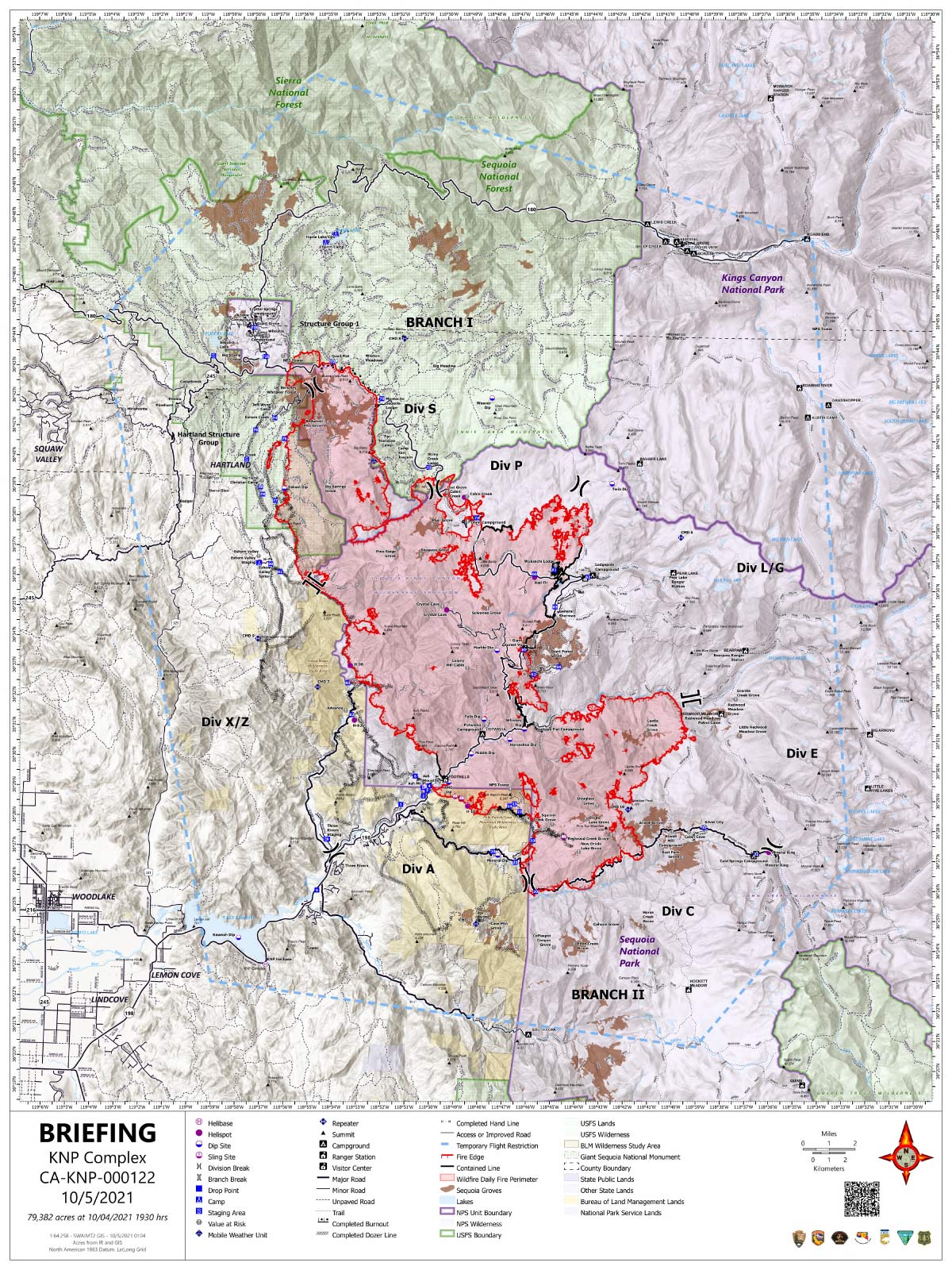
Tuesday's Briefing Map
Briefing Map Shows Divisions, Uncontrolled Fire Edge, Completed Dozer Lines.
Note: Map is 1,200 pixels wide.