Click here for Thursday's Updates: KNP Complex Wildfires in Sequoia National Park Thursday, October 7, 2021 Updates
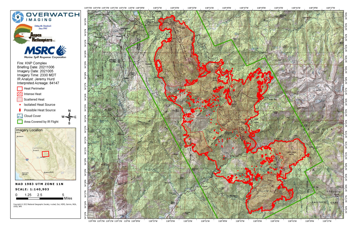
Wednesday's Infrared Map
Note: Map is 1,200 pixels wide.
Click here for Thursday's Updates: KNP Complex Wildfires in Sequoia National Park Thursday, October 7, 2021 Updates
Update 9:20 A.M. Announcement From Tulare County Sheriff's Office
Tulare County Sheriff's Facebook Page Map for Evacuation Orders and Warnings
October 6, 2021
HAPPENING NOW: New Evacuation Orders Underway For KNP Complex Fire
Sheriff Boudreaux has issued an evacuation order for All residences on both sides of North Fork from Sheep Creek to Yucca Creek and Dinley Drive. There will be a road closure at North Fork at Sheep Creek.
Evacuation WARNINGS still remain in place for all structures from Old Three Rivers Rd and Blossom Dr to South Fork Dr, including South Fork Dr up HWY 198 to Mineral King Dr, including North Fork Dr, also including all side roads along HWY 198 to Mineral King Dr.
Please refer to https://tularecounty.ca.gov/emergencies/ KNP Complex Evacuation Area Map for more information.
Morning Update:
Southwest Area Type 1 Incident Management Team 2 Dave Bales– Incident Commander
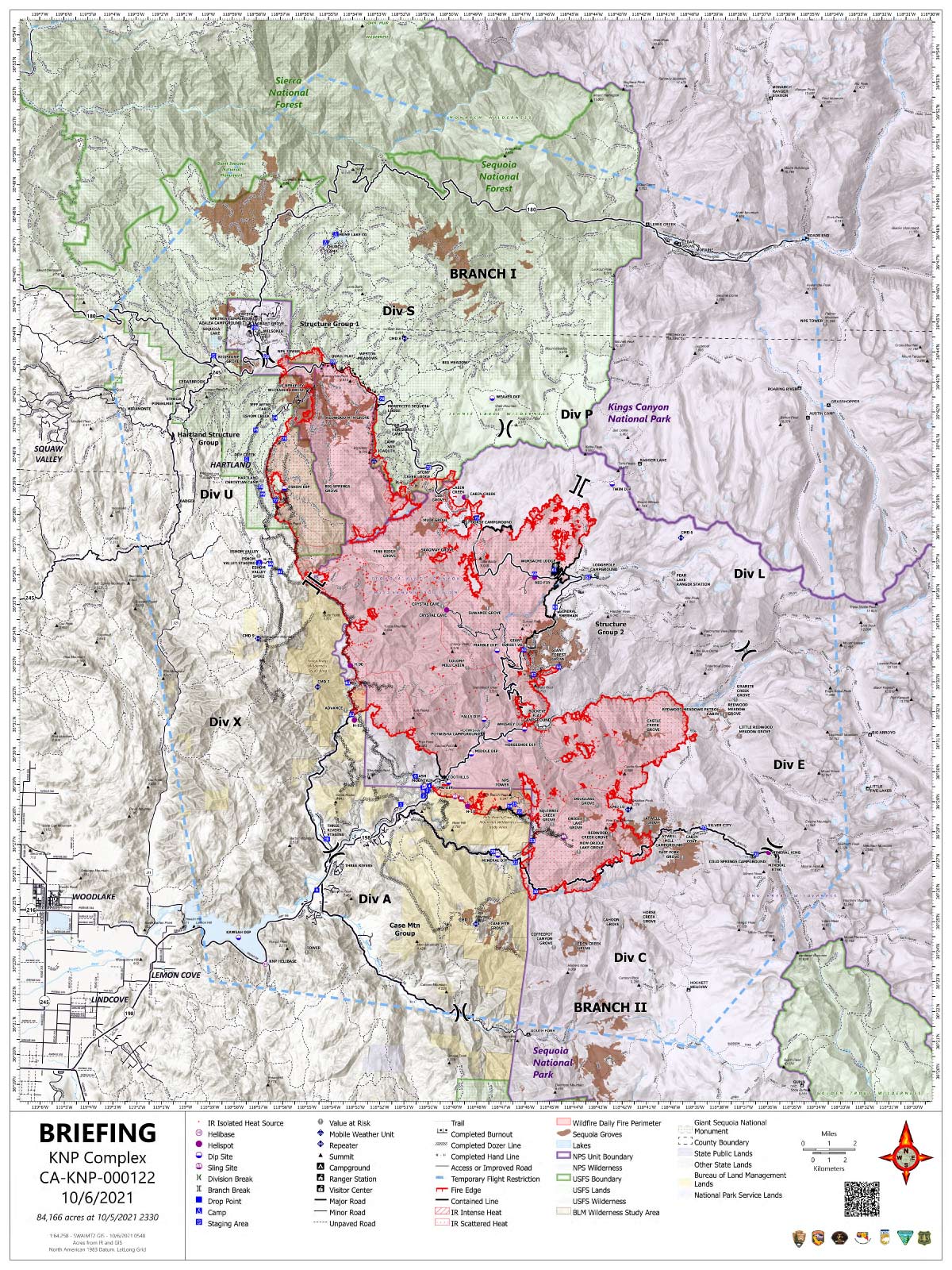
Acres: 84,166 acres
Containment: 11 %
Start Date: September 10, 2021
Cause: Lightning
Jurisdiction: Sequoia and Kings Canyon National Parks; Sequoia National Forest
Resources: 1,866 personnel including: 38 crews, 111 engines, 34 water tenders, 20 dozers and 13 helicopters
Yesterday, resources successfully conducted tactical firing operations to keep the fire east of Hartland by utilizing natural and constructed holding features along the northwest perimeter. Structure protection continues in Wilsonia, Grant Grove, Quail Flat, and Weston Meadow. Spot fires north of Generals Highway were actively burning through heavy accumulations of fuels on the forest floor. On the north side, bucket drops were used in areas east and north of the Generals Highway. On the southern end, helicopters supported crews as they constructed hose lays on the west side of Mineral King Road.
Today, firefighters continue to construct containment lines along Old Sawmill Road. Hand crews are building direct line from the Park Ridge Lookout (NPS Tower) to the Generals Highway. These efforts are to protect the communities of Wilsonia and Grant Grove. Farther east, firefighters continue to build direct line to contain the fire that has crossed north of Generals Highway near Stoney and Cabin creeks. On the eastern edge of the fire, resources are conducting tactical firing operations east of Morro Rock to protect the Giant Forest Grove. On the southern perimeter, crews are working to prevent the fire from moving toward Oak Grove. Resources on the west flank are working to secure a spot fire overnight. Helicopters and fixed wing aircraft are available to support ground resources across the fire area as smoke lifts and visibility allows.
Firefighters are working hard to contain the KNP Complex Fire. There is a lot of interest in the condition of campgrounds, Sequoia Groves, and historic structures. Current fire conditions are preventing a thorough assessment of the many structures across the fire. In the early days of the fire, two structures in Oriole Lake were damaged or destroyed. Despite clearing of vegetation, water drops and structure wrap, the historic cabin in Redwood Mountain Grove was destroyed by fire on October 4, 2021.
Lighter winds combined with an increase in humidity and a decrease in temperatures should help to slow fire spread. Clouds will begin to move into the area over the next few days.
Please continue to turn on your lights and watch out for fire equipment moving up and down roads. We want to keep both the firefighters and the public safe.
For more detailed information on Evacuation orders and Warnings you can visit: https://nifc.maps.arcgis.com/apps/webappviewer/index.html?id=4b2ac27b5c8943ed92c0e77aa94daca0
Information about how to prepare for evacuations can be found at https://www.readyforwildfire.org/
Sequoia and Kings Canyon National Parks are closed west of the Pacific Crest Trail and south of the ridgeline which lies north of Ionian Basin. In addition, the BLM Case Mountain Extensive Recreation Management Area and major portions of the Sequoia National Forest are also closed. View closures at
Communities surrounding the park and in the nearby region are being affected by smoke and the resulting poor air quality. Track your local air quality at https://www.wildlandfiresmoke.net/outlooks/FresnoCA.
Basic Information 84,166 Acres with 11% Containment
| Current as of | 10/6/2021, 9:07:19 AM |
| Incident Type | Wildfire |
| Cause | Lightning |
| Date of Origin | Friday September 10th, 2021 approx. 07:00 AM |
| Location | Sequoia National Park |
| Incident Commander | David Bales |
| Incident Description | Complex |
| Coordinates | 36.567 latitude, -118.811 longitude |
Current Situation
| Total Personnel | 1,866 |
| Size | 84,166 Acres |
| Percent of Perimeter Contained | 11% |
| Fuels Involved |
Timber (Litter and Understory) Chaparral (6 feet) Short Grass (1 foot) |
| Significant Events |
Observed Fire Behavior: Active, Uphill Runs, Running, Short-range Spotting Narrative: A decrease in fire behavior from the increase in humidity. Some active to very active fire behavior with upslope runs. |
Outlook
| Planned Actions |
Utilize direct and indirect tactics including firing operations, ground resources and heavy equipment. Structure protection and perimeter control measures will be taken around structures within threatened communities. Conduct structure protection and mitigation efforts for National Park features (infrastructure, Headquarters, Museum, employee housing) and adjacent communities. Continued protection and mitigation measures for all sequoia groves within the fire area. When attributes of fire behavior are favorable to the landscape, allow fire to spread to aid in fuels reduction in around the groves. |
| Projected Incident Activity |
12 hours: Fire behavior will moderate through the night as the humidity increases. Downslope winds will continue to influence fire movement. 24 hours: Fuel moisture increase with the higher humidity. Expect fire behavior to be moderate to active unless fuels, slope and winds align then very active fire behavior is possible. 48 hours: Cloud cover along with higher humidity will lower fire behavior with moderate being the most common. 72 hours: Precipitation will keep the fire behavior low and limit growth. Anticipated after 72 hours: Moist fuels will keep fire behavior low. |
Current Weather
| Weather Concerns |
Low pressure to the south brought slightly increased humidity, along with southerly flow aloft. This continued to push smoke northward through the day. Winds aloft will continue from the south and west during the next few days as another trough moves down the California Coast. |
Update: Smoke/Air Quality Outlook for the KNP Complex Wildfires in Sequoia National Park for Wednesday, October 6, 2021
October 6, 2021 - KNP Complex Fire in Sequoia National Park updates for Wednesday: 84,147 Acres.
Overnight Infrared Flight Notes: Interpreted Size: 84,147 Interpreted Acres - Growth since last flight: About 21,388 Acres
Major growth in Div U, S,P
Minor growth in Div X
Perimeter extended to the south in Dev A and crossed Mineral Road
Click here for: KNP Complex Wildfires in Sequoia National Park Tuesday, October 5, 2021 Updates
Wednesday's Briefing Map
Briefing Map Shows Divisions, Uncontrolled Fire Edge, Completed Dozer Lines.
Note: Map is 1,200 pixels wide.