Update - KNP Complex Special Announcement:
At approximately 3:00 P.M. this afternoon, the KNP Complex received a radio transmission that a tree had fallen, striking four individuals working on the KNP Complex Fire. The patients were all brought to the nearest helispot and were transported by air to area hospitals. All four individuals are receiving medical care. Thankfully, while the injuries are serious, they are in stable condition, and we are grateful.
Source: Sequoia and Kings Canyon National Parks
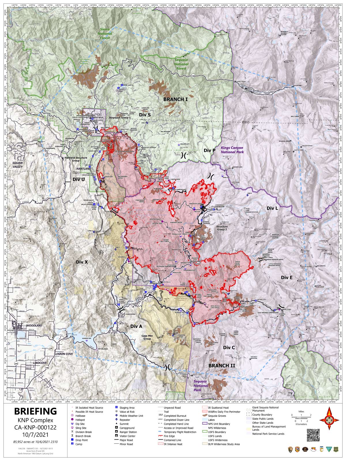
Thursday's Infrared Map
Note: Map is 1,200 pixels wide.
Update:
Southwest Area Type 1 Incident Management Team 2
Dave Bales – Incident Commander
Acres: 85,952 acres
Containment: 11 %
Start Date: September 10, 2021
Cause: Lightning
Jurisdiction: Sequoia and Kings Canyon National Parks; Sequoia National Forest
Resources: 1,951 personnel including: 38 crews, 123 engines, 37 water tenders, 21 dozers and 13 helicopters
California Incident Management Team 2, a type one team, has arrived and preparation has begun to separate the KNP Complex into two geographical zones in order to support suppression efforts across the fire area. This team will spend the day gathering information and take control of the KNP Complex North Zone at 6:00 p.m. tonight, Thursday,
October 7, 2021. Southwest Team 2 will remain in command of the KNP Complex South Zone as this transition occurs.
Yesterday: Firefighters continued with tactical firing operations to the north along Old Sawmill Road. On the northern perimeter, the fire crossed a portion of Generals Highway but was caught by crews securing handline around the fires edge. Structure protection continued around Wilsonia, Grant Grove Village and surrounding communities. Crews were able to stop forward progress and place hose lay on the 75-acre spot on the western edge near Advance. An increase in visibility provided opportunities for helicopters to support ground resources with bucket drops for both the 75-acre growth and hotspots located south of Mineral King Road.
Today: Work continues in Eshom Creek with crews connecting the contingency line to Generals Highway along the northwestern corner of the fire. Firefighters are patrolling Old Sawmill Road to ensure the fire stays within the containment line where tactical firing operations are occurring. Structure protection remains in place for Grant Grove Village, Wilsonia, and surrounding communities. Heavy equipment, such as dozers and masticators, are working in coordination with crews to improve contingency lines north of Generals Highway near Park Ridge. Resources are clearing vegetation around Bearskin, Tenmile, Landslide, Grant, and Big Stump sequoia groves to protect areas to the north. For the northeast portion of the fire, dozers are working in the Stony Creek area to clear heavy, dead and down vegetation to provide safe access for crews engaging directly on the fires edge with suppression efforts. Firefighters working on the south end of KNP Complex are improving handline and checking hose lays along the Mineral King Road, east of Oak Grove. Crews are working along the western perimeter near North Fork Drive to locate and cool any hotspots on the 75-acre spot to prevent future growth. Helicopters are available to support firefighters on the ground with bucket drops and reconnaissance flights as visibility allows for the safe operation of flight crews.
Safety: For the safety of the firefighters and public, please observe all closures in place for the Forest Service and National Park. Turn on headlights and slow down when traveling within surrounding communities.
Weather: Light winds, slight decrease in temperature and increase in relative humidities are expected to help moderate fire behavior and slow fire spread. Clouds will move into the area during the afternoon with precipitation possible over the fire late Thursday evening, early Friday morning. Snow is forecasted for the higher elevations as we move into Friday.
Evacuations: Evacuation ORDERS and WARNINGS are in place. For the most up-to-date information, visit: https://nifc.maps.arcgis.com/apps/webappviewer/index.html?id=4b2ac27b5c8943ed92c0e77aa94daca0. Learn to prepare for an evacuation by visiting https://www.readyforwildfire.org/.
Closures: Sequoia and Kings Canyon National Parks are closed west of the Pacific Crest Trail and south of the ridgeline which lies north of Ionian Basin. In addition, the BLM Case Mountain Extensive Recreation Management Area and major portions of the Sequoia National Forest are also closed. View Closures at: https://inciweb.nwcg.gov/incident/closures/7838/
Smoke Impacts: Smoke will remain visible across the fire area as the fire consumes unburned pockets of vegetation. Current air quality updates can be found at https://www.wildlandfiresmoke.net/outlooks/FresnoCA.
Update 7:50 A.M. Smoke/Air Quality Outlook for the KNP Complex Wildfires in Sequoia National Park for Thursday, October 7, 2021
Basic Information 85,952 Acres with 11% Containment
| Current as of | 10/7/2021, 6:58:51 AM |
| Incident Type | Wildfire |
| Cause | Lightning |
| Date of Origin | Friday September 10th, 2021 approx. 07:00 AM |
| Location | Sequoia National Park |
| Incident Commander | David Bales |
| Incident Description | Complex |
| Coordinates | 36.567 latitude, -118.811 longitude |
Current Situation
| Total Personnel | 1,951 |
| Size | 85,952 Acres |
| Percent of Perimeter Contained | 11% |
| Fuels Involved |
Timber (Litter and Understory) Chaparral (6 feet) Short Grass (1 foot) |
| Significant Events |
Observed Fire Behavior: Active Uphill Runs Isolated Torching Short-range Spotting Narrative: Fire behavior decreased as the humidity increased. Some short range spotting occurred early in the day. Overnight the downslope winds helped push the fire west in Division X. |
Outlook
| Planned Actions |
Utilize direct and indirect tactics including firing operations, ground resources and heavy equipment. Structure protection and perimeter control measures will be taken around structures within threatened communities. Conduct structure protection and mitigation efforts for National Park features (infrastructure, Headquarters, Museum, employee housing) and adjacent communities. Continued protection and mitigation measures for all sequoia groves within the fire area. When attributes of fire behavior are favorable to the landscape, allow fire to spread to aid in fuels reduction in around the groves. |
| Projected Incident Activity |
12 hours: Overnight recoveries will help to moderate fire behavior. Low to moderate fire behavior is expected. 24 hours: The humidity continues to increase causing the fire behavior to be low to moderate. 48 hours: Precipitation over the fire will greatly lower the fire behavior to smoldering. 72 hours: Fuel moistures will be elevated because of the recent rainfall. Smoldering fire behavior will continue. Anticipated after 72 hours: Fuels will begin to dry allowing for smoldering fire behavior. |
Current Weather
| Weather Concerns |
Low pressure will develop off the California coast bringing a southwesterly flow aloft. This will help push smoke to the east and keep air clearer for air operations as well as allow for more sun over the fire. A cold front will move across the fire area Thursday night and Friday with a chance of wetting rain, high elevation snow, much cooler temperatures and sharply increased relative humidity. |
October 7, 2021 - KNP Complex Fire in Sequoia National Park updates for Thursday: 85,952 Acres.
Overnight Infrared Flight Notes: Interpreted Size: 85,952 Interpreted Acres - Growth since last flight: About 1,805 Acres
Minimal growth to perimeter. Scattered heat remains throughout most of the incident with some intense heat in localized areas.
Thursday's Briefing Map
Briefing Map Shows Divisions, Uncontrolled Fire Edge, Completed Dozer Lines.
Note: Map is 1,200 pixels wide.